

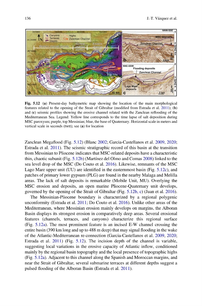
Zanclean Megaflood (Fig. 5.12) (Blanc 2002; Garcia-Castellanos et al. 2009, 2020;
Estrada et al. 2011). The seismic stratigraphic record of this basin at the transition
from Messinian to Pliocene indicates that MSC-related deposits have a characteristic
thin, chaotic subunit (Fig. 5.12b) (Martínez del Olmo and Comas 2008) linked to the
sea level drop of the MSC (Do Couto et al. 2016). Likewise, remnants of the MSC
Lago Mare upper unit (UU) are identified in the easternmost basin (Fig. 5.12c), and
patches of primary lower gypsum (PLG) are found in the nearby Malaga and Melilla
areas. The lack of salt deposits is remarkable (Mobile Unit, MU). Overlying the
MSC erosion and deposits, an open marine Pliocene-Quaternary unit develops,
governed by the opening of the Strait of Gibraltar (Fig. 5.12b, c) (Juan et al. 2016).
The Messinian-Pliocene boundary is characterized by a regional polygenic
unconformity (Estrada et al. 2011; Do Couto et al. 2016). Unlike other areas of the
Mediterranean, where Messinian erosion mainly develops on margins, the Alboran
Basin displays its strongest erosion in comparatively deep areas. Several erosional
features (channels, terraces, and canyons) characterize this regional surface
(Fig. 5.12a). The most prominent feature is an incised E-W channel crossing the
entire basin (390 km long and up to 488 m deep) that may signal flooding in the wake
of the Atlantic-Mediterranean re-connection (Garcia-Castellanos et al. 2009, 2020;
Estrada et al. 2011) (Fig. 5.12). The incision depth of the channel is variable,
suggesting local variations in the erosive capacity of Atlantic inflow, conditioned
mainly by the regional basin topography and the local presence of topographic highs
(Fig. 5.12a). Adjacent to this channel along the Spanish and Moroccan margins, and
near the Strait of Gibraltar, several submarine terraces at different depths suggest a
pulsed flooding of the Alboran Basin (Estrada et al. 2011).
Fig. 5.12 (a) Present-day bathymetric map showing the location of the main morphological
features related to the opening of the Strait of Gibraltar (modified from Estrada et al. 2011); (b)
and (c) seismic profiles showing the erosive channel related with the Zanclean reflooding of the
Mediterranean Sea. Legend: Yellow line corresponds to the time lapse of salt deposition during
MSC paroxysm; purple, top Messinian; blue, the base of Quaternary. Horizontal scale in meters and
vertical scale in seconds (twtt); see (a) for location
136
J.-T. Vázquez et al.
Estrada et al. 2011). The seismic stratigraphic record of this basin at the transition
from Messinian to Pliocene indicates that MSC-related deposits have a characteristic
thin, chaotic subunit (Fig. 5.12b) (Martínez del Olmo and Comas 2008) linked to the
sea level drop of the MSC (Do Couto et al. 2016). Likewise, remnants of the MSC
Lago Mare upper unit (UU) are identified in the easternmost basin (Fig. 5.12c), and
patches of primary lower gypsum (PLG) are found in the nearby Malaga and Melilla
areas. The lack of salt deposits is remarkable (Mobile Unit, MU). Overlying the
MSC erosion and deposits, an open marine Pliocene-Quaternary unit develops,
governed by the opening of the Strait of Gibraltar (Fig. 5.12b, c) (Juan et al. 2016).
The Messinian-Pliocene boundary is characterized by a regional polygenic
unconformity (Estrada et al. 2011; Do Couto et al. 2016). Unlike other areas of the
Mediterranean, where Messinian erosion mainly develops on margins, the Alboran
Basin displays its strongest erosion in comparatively deep areas. Several erosional
features (channels, terraces, and canyons) characterize this regional surface
(Fig. 5.12a). The most prominent feature is an incised E-W channel crossing the
entire basin (390 km long and up to 488 m deep) that may signal flooding in the wake
of the Atlantic-Mediterranean re-connection (Garcia-Castellanos et al. 2009, 2020;
Estrada et al. 2011) (Fig. 5.12). The incision depth of the channel is variable,
suggesting local variations in the erosive capacity of Atlantic inflow, conditioned
mainly by the regional basin topography and the local presence of topographic highs
(Fig. 5.12a). Adjacent to this channel along the Spanish and Moroccan margins, and
near the Strait of Gibraltar, several submarine terraces at different depths suggest a
pulsed flooding of the Alboran Basin (Estrada et al. 2011).
Fig. 5.12 (a) Present-day bathymetric map showing the location of the main morphological
features related to the opening of the Strait of Gibraltar (modified from Estrada et al. 2011); (b)
and (c) seismic profiles showing the erosive channel related with the Zanclean reflooding of the
Mediterranean Sea. Legend: Yellow line corresponds to the time lapse of salt deposition during
MSC paroxysm; purple, top Messinian; blue, the base of Quaternary. Horizontal scale in meters and
vertical scale in seconds (twtt); see (a) for location
136
J.-T. Vázquez et al.