

et al. 2013, 2017; Do Couto et al. 2016; Gómez de la Peña et al. 2018). Depth to
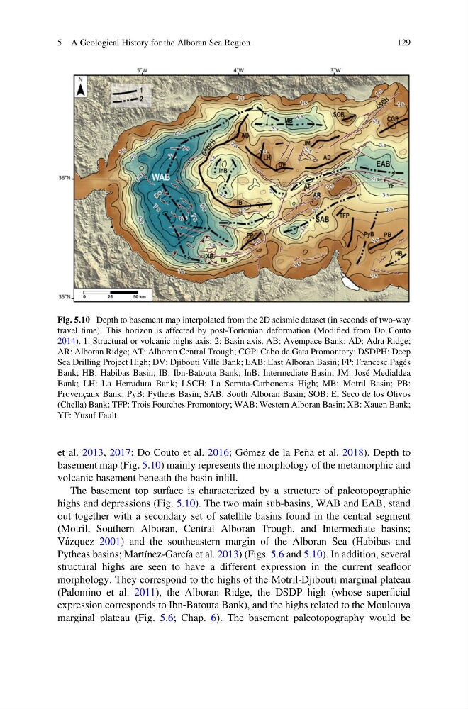
basement map (Fig. 5.10) mainly represents the morphology of the metamorphic and
volcanic basement beneath the basin infill.
The basement top surface is characterized by a structure of paleotopographic
highs and depressions (Fig. 5.10). The two main sub-basins, WAB and EAB, stand
out together with a secondary set of satellite basins found in the central segment
(Motril, Southern Alboran, Central Alboran Trough, and Intermediate basins;
Vázquez 2001) and the southeastern margin of the Alboran Sea (Habibas and
Pytheas basins; Martínez-García et al. 2013) (Figs. 5.6 and 5.10). In addition, several
structural highs are seen to have a different expression in the current seafloor
morphology. They correspond to the highs of the Motril-Djibouti marginal plateau
(Palomino et al. 2011), the Alboran Ridge, the DSDP high (whose superficial
expression corresponds to Ibn-Batouta Bank), and the highs related to the Moulouya
marginal plateau (Fig. 5.6; Chap. 6). The basement paleotopography would be
Fig. 5.10 Depth to basement map interpolated from the 2D seismic dataset (in seconds of two-way
travel time). This horizon is affected by post-Tortonian deformation (Modified from Do Couto
2014). 1: Structural or volcanic highs axis; 2: Basin axis. AB: Avempace Bank; AD: Adra Ridge;
AR: Alboran Ridge; AT: Alboran Central Trough; CGP: Cabo de Gata Promontory; DSDPH: Deep
Sea Drilling Project High; DV: Djibouti Ville Bank; EAB: East Alboran Basin; FP: Francesc Pagés
Bank; HB: Habibas Basin; IB: Ibn-Batouta Bank; InB: Intermediate Basin; JM: José Medialdea
Bank; LH: La Herradura Bank; LSCH: La Serrata-Carboneras High; MB: Motril Basin; PB:
Provençaux Bank; PyB: Pytheas Basin; SAB: South Alboran Basin; SOB: El Seco de los Olivos
(Chella) Bank; TFP: Trois Fourches Promontory; WAB: Western Alboran Basin; XB: Xauen Bank;
YF: Yusuf Fault
5 A Geological History for the Alboran Sea Region
129
basement map (Fig. 5.10) mainly represents the morphology of the metamorphic and
volcanic basement beneath the basin infill.
The basement top surface is characterized by a structure of paleotopographic
highs and depressions (Fig. 5.10). The two main sub-basins, WAB and EAB, stand
out together with a secondary set of satellite basins found in the central segment
(Motril, Southern Alboran, Central Alboran Trough, and Intermediate basins;
Vázquez 2001) and the southeastern margin of the Alboran Sea (Habibas and
Pytheas basins; Martínez-García et al. 2013) (Figs. 5.6 and 5.10). In addition, several
structural highs are seen to have a different expression in the current seafloor
morphology. They correspond to the highs of the Motril-Djibouti marginal plateau
(Palomino et al. 2011), the Alboran Ridge, the DSDP high (whose superficial
expression corresponds to Ibn-Batouta Bank), and the highs related to the Moulouya
marginal plateau (Fig. 5.6; Chap. 6). The basement paleotopography would be
Fig. 5.10 Depth to basement map interpolated from the 2D seismic dataset (in seconds of two-way
travel time). This horizon is affected by post-Tortonian deformation (Modified from Do Couto
2014). 1: Structural or volcanic highs axis; 2: Basin axis. AB: Avempace Bank; AD: Adra Ridge;
AR: Alboran Ridge; AT: Alboran Central Trough; CGP: Cabo de Gata Promontory; DSDPH: Deep
Sea Drilling Project High; DV: Djibouti Ville Bank; EAB: East Alboran Basin; FP: Francesc Pagés
Bank; HB: Habibas Basin; IB: Ibn-Batouta Bank; InB: Intermediate Basin; JM: José Medialdea
Bank; LH: La Herradura Bank; LSCH: La Serrata-Carboneras High; MB: Motril Basin; PB:
Provençaux Bank; PyB: Pytheas Basin; SAB: South Alboran Basin; SOB: El Seco de los Olivos
(Chella) Bank; TFP: Trois Fourches Promontory; WAB: Western Alboran Basin; XB: Xauen Bank;
YF: Yusuf Fault
5 A Geological History for the Alboran Sea Region
129