

unconformably over the Malaguide-Alpujarride basement and is associated with
E-W trending, generally top-to-the-E and top-to-the-N extensional structures
(Crespo-Blanc 1995; González-Lodeiro et al. 1996; Suades and Crespo-Blanc
2013). The oldest sedimentary series rework pebbles, blocks, and olistoliths of
basement rocks, thus evidencing denudation and intense erosion accompanying
the tectonic activity (Serrano et al. 2007; Suades and Crespo-Blanc 2013). The
asymmetric geometry of the sedimentary basins, the transgressive character of the
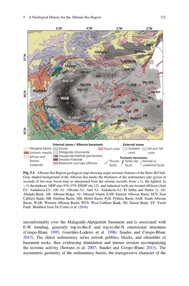
Fig. 5.4 Alboran Sea Region geological map showing major tectonic features of the Betic-Rif belt.
Gray shaded background of the Alboran Sea marks the thickness of the sedimentary pile (given in
seconds of two-way travel time as interpreted from the seismic records, from <1s, the lightest, to
>7s the darkest). ODP sites 976–979, DSDP site 121, and industrial wells are located offshore (And
G1: Andalucía-G1; Alb A1: Alborán-A1; And A1: Andalucía-A1; El Jebha and Nador 1). Ab:
Alidada Bank; AR: Alboran Ridge; AI: Alboran Island; EAB: Eastern Alboran Basin; ECb: East
Cabliers Bank; HB: Habibas Basin; MB: Motril Basin; PyB: Pytheas Basin; SAB: South Alboran
Basin; WAB: Western Alboran Basin; WCb: West Cabliers Bank; Xb: Xauen Bank; YF: Yusuf
Fault. Modified from Do Couto et al. (2016)
5 A Geological History for the Alboran Sea Region
121
E-W trending, generally top-to-the-E and top-to-the-N extensional structures
(Crespo-Blanc 1995; González-Lodeiro et al. 1996; Suades and Crespo-Blanc
2013). The oldest sedimentary series rework pebbles, blocks, and olistoliths of
basement rocks, thus evidencing denudation and intense erosion accompanying
the tectonic activity (Serrano et al. 2007; Suades and Crespo-Blanc 2013). The
asymmetric geometry of the sedimentary basins, the transgressive character of the
Fig. 5.4 Alboran Sea Region geological map showing major tectonic features of the Betic-Rif belt.
Gray shaded background of the Alboran Sea marks the thickness of the sedimentary pile (given in
seconds of two-way travel time as interpreted from the seismic records, from <1s, the lightest, to
>7s the darkest). ODP sites 976–979, DSDP site 121, and industrial wells are located offshore (And
G1: Andalucía-G1; Alb A1: Alborán-A1; And A1: Andalucía-A1; El Jebha and Nador 1). Ab:
Alidada Bank; AR: Alboran Ridge; AI: Alboran Island; EAB: Eastern Alboran Basin; ECb: East
Cabliers Bank; HB: Habibas Basin; MB: Motril Basin; PyB: Pytheas Basin; SAB: South Alboran
Basin; WAB: Western Alboran Basin; WCb: West Cabliers Bank; Xb: Xauen Bank; YF: Yusuf
Fault. Modified from Do Couto et al. (2016)
5 A Geological History for the Alboran Sea Region
121