

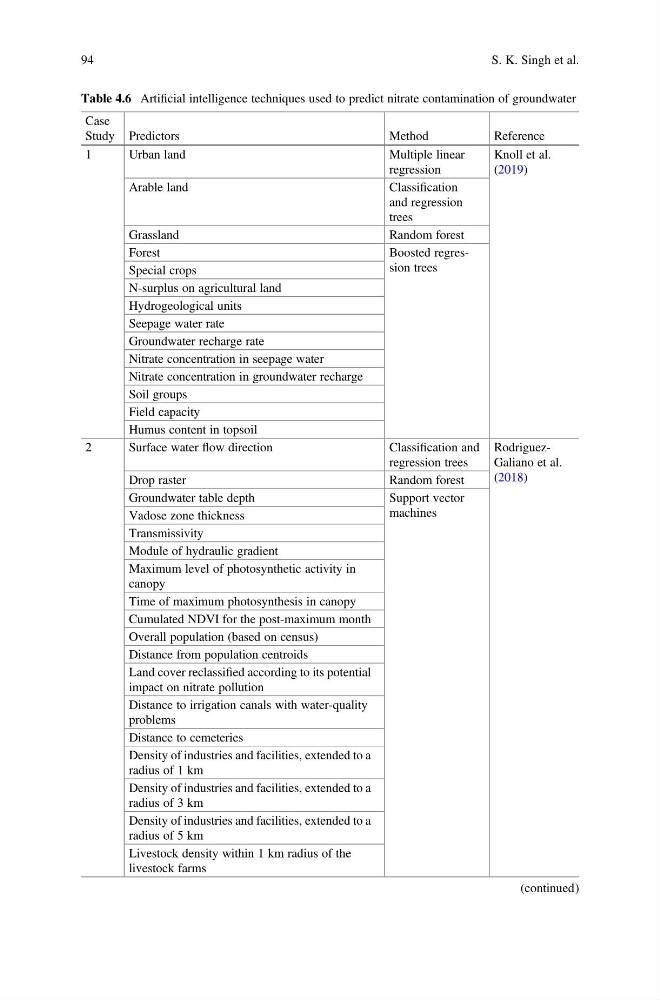
Table 4.6 Artificial intelligence techniques used to predict nitrate contamination of groundwater
Case
Study Predictors
Method
Reference
1
Urban land
Multiple linear
regression
Knoll et al.
(2019)
Arable land
Classification
and regression
trees
Grassland
Random forest
Forest
Boosted regression trees
Special crops
N-surplus on agricultural land
Hydrogeological units
Seepage water rate
Groundwater recharge rate
Nitrate concentration in seepage water
Nitrate concentration in groundwater recharge
Soil groups
Field capacity
Humus content in topsoil
2
Surface water flow direction
Classification and
regression trees
RodriguezGaliano et al.
(2018)
Drop raster
Random forest
Groundwater table depth
Support vector
machines
Vadose zone thickness
Transmissivity
Module of hydraulic gradient
Maximum level of photosynthetic activity in
canopy
Time of maximum photosynthesis in canopy
Cumulated NDVI for the post-maximum month
Overall population (based on census)
Distance from population centroids
Land cover reclassified according to its potential
impact on nitrate pollution
Distance to irrigation canals with water-quality
problems
Distance to cemeteries
Density of industries and facilities, extended to a
radius of 1 km
Density of industries and facilities, extended to a
radius of 3 km
Density of industries and facilities, extended to a
radius of 5 km
Livestock density within 1 km radius of the
livestock farms
(continued)
94
S. K. Singh et al.
Case
Study Predictors
Method
Reference
1
Urban land
Multiple linear
regression
Knoll et al.
(2019)
Arable land
Classification
and regression
trees
Grassland
Random forest
Forest
Boosted regression trees
Special crops
N-surplus on agricultural land
Hydrogeological units
Seepage water rate
Groundwater recharge rate
Nitrate concentration in seepage water
Nitrate concentration in groundwater recharge
Soil groups
Field capacity
Humus content in topsoil
2
Surface water flow direction
Classification and
regression trees
RodriguezGaliano et al.
(2018)
Drop raster
Random forest
Groundwater table depth
Support vector
machines
Vadose zone thickness
Transmissivity
Module of hydraulic gradient
Maximum level of photosynthetic activity in
canopy
Time of maximum photosynthesis in canopy
Cumulated NDVI for the post-maximum month
Overall population (based on census)
Distance from population centroids
Land cover reclassified according to its potential
impact on nitrate pollution
Distance to irrigation canals with water-quality
problems
Distance to cemeteries
Density of industries and facilities, extended to a
radius of 1 km
Density of industries and facilities, extended to a
radius of 3 km
Density of industries and facilities, extended to a
radius of 5 km
Livestock density within 1 km radius of the
livestock farms
(continued)
94
S. K. Singh et al.