

methods improves for large accumulation times. The improvement of precipitation
estimation by the radar–raingauge merging techniques also varies between seasons
[105, 111] and between storms [115, 117]. Since the radar–raingauge merging
method is the final step for radar-based precipitation estimation, minimizing all the
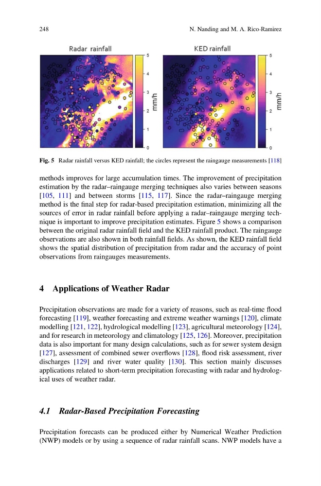
sources of error in radar rainfall before applying a radar–raingauge merging technique is important to improve precipitation estimates. Figure 5 shows a comparison
between the original radar rainfall field and the KED rainfall product. The raingauge
observations are also shown in both rainfall fields. As shown, the KED rainfall field
shows the spatial distribution of precipitation from radar and the accuracy of point
observations from raingauges measurements.
4 Applications of Weather Radar
Precipitation observations are made for a variety of reasons, such as real-time flood
forecasting [119], weather forecasting and extreme weather warnings [120], climate
modelling [121, 122], hydrological modelling [123], agricultural meteorology [124],
and for research in meteorology and climatology [125, 126]. Moreover, precipitation
data is also important for many design calculations, such as for sewer system design
[127], assessment of combined sewer overflows [128], flood risk assessment, river
discharges [129] and river water quality [130]. This section mainly discusses
applications related to short-term precipitation forecasting with radar and hydrological uses of weather radar.
4.1 Radar-Based Precipitation Forecasting
Precipitation forecasts can be produced either by Numerical Weather Prediction
(NWP) models or by using a sequence of radar rainfall scans. NWP models have a
Fig. 5 Radar rainfall versus KED rainfall; the circles represent the raingauge measurements [118]
248
N. Nanding and M. A. Rico-Ramirez
estimation by the radar–raingauge merging techniques also varies between seasons
[105, 111] and between storms [115, 117]. Since the radar–raingauge merging
method is the final step for radar-based precipitation estimation, minimizing all the
sources of error in radar rainfall before applying a radar–raingauge merging technique is important to improve precipitation estimates. Figure 5 shows a comparison
between the original radar rainfall field and the KED rainfall product. The raingauge
observations are also shown in both rainfall fields. As shown, the KED rainfall field
shows the spatial distribution of precipitation from radar and the accuracy of point
observations from raingauges measurements.
4 Applications of Weather Radar
Precipitation observations are made for a variety of reasons, such as real-time flood
forecasting [119], weather forecasting and extreme weather warnings [120], climate
modelling [121, 122], hydrological modelling [123], agricultural meteorology [124],
and for research in meteorology and climatology [125, 126]. Moreover, precipitation
data is also important for many design calculations, such as for sewer system design
[127], assessment of combined sewer overflows [128], flood risk assessment, river
discharges [129] and river water quality [130]. This section mainly discusses
applications related to short-term precipitation forecasting with radar and hydrological uses of weather radar.
4.1 Radar-Based Precipitation Forecasting
Precipitation forecasts can be produced either by Numerical Weather Prediction
(NWP) models or by using a sequence of radar rainfall scans. NWP models have a
Fig. 5 Radar rainfall versus KED rainfall; the circles represent the raingauge measurements [118]
248
N. Nanding and M. A. Rico-Ramirez