

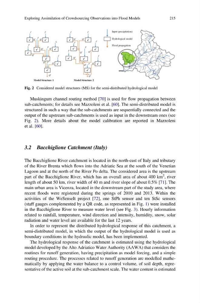
Muskingum channel routing method [70] is used for flow propagation between
sub-catchments; for details see Mazzoleni et al. [60]. The semi-distributed model is
structured in such a way that the sub-catchments are sequentially connected and the
output of the upstream sub-catchments is used as input in the downstream ones (see
Fig. 2). More details about the model calibration are reported in Mazzoleni
et al. [60].
3.2 Bacchiglione Catchment (Italy)
The Bacchiglione River catchment is located in the north-east of Italy and tributary
of the River Brenta which flows into the Adriatic Sea at the south of the Venetian
Lagoon and at the north of the River Po delta. The considered area is the upstream
part of the Bacchiglione River, which has an overall area of about 400 km
2 , river
length of about 50 km, river width of 40 m and river slope of about 0.5% [71]. The
main urban area is Vicenza, located in the downstream part of the study area, where
recent floods were registered during the springs of 2010 and 2013. Within the
activities of the WeSenseIt project [72], one StPh sensor and ten StSc sensors
(staff gauges complemented by a QR code, as represented in Fig. 1) were installed
in the Bacchiglione River to measure water level (see Fig. 3). Hourly information
related to rainfall, temperature, wind direction and intensity, humidity, snow, solar
radiation and water level are available for the last 12 years.
In order to represent the distributed hydrological response of this catchment, a
semi-distributed model, in which the output of the hydrological model is used as
boundary conditions in the hydraulic model, has been implemented.
The hydrological response of the catchment is estimated using the hydrological
model developed by the Alto Adriatico Water Authority (AAWA) that considers the
routines for runoff generation, having precipitation as model forcing, and a simple
routing procedure. The processes related to runoff generation are modelled mathematically by applying the water balance to a control volume, of soil depth, representative of the active soil at the sub-catchment scale. The water content is estimated
Fig. 2 Considered model structures (MS) for the semi-distributed hydrological model
Exploring Assimilation of Crowdsourcing Observations into Flood Models
215
sub-catchments; for details see Mazzoleni et al. [60]. The semi-distributed model is
structured in such a way that the sub-catchments are sequentially connected and the
output of the upstream sub-catchments is used as input in the downstream ones (see
Fig. 2). More details about the model calibration are reported in Mazzoleni
et al. [60].
3.2 Bacchiglione Catchment (Italy)
The Bacchiglione River catchment is located in the north-east of Italy and tributary
of the River Brenta which flows into the Adriatic Sea at the south of the Venetian
Lagoon and at the north of the River Po delta. The considered area is the upstream
part of the Bacchiglione River, which has an overall area of about 400 km
2 , river
length of about 50 km, river width of 40 m and river slope of about 0.5% [71]. The
main urban area is Vicenza, located in the downstream part of the study area, where
recent floods were registered during the springs of 2010 and 2013. Within the
activities of the WeSenseIt project [72], one StPh sensor and ten StSc sensors
(staff gauges complemented by a QR code, as represented in Fig. 1) were installed
in the Bacchiglione River to measure water level (see Fig. 3). Hourly information
related to rainfall, temperature, wind direction and intensity, humidity, snow, solar
radiation and water level are available for the last 12 years.
In order to represent the distributed hydrological response of this catchment, a
semi-distributed model, in which the output of the hydrological model is used as
boundary conditions in the hydraulic model, has been implemented.
The hydrological response of the catchment is estimated using the hydrological
model developed by the Alto Adriatico Water Authority (AAWA) that considers the
routines for runoff generation, having precipitation as model forcing, and a simple
routing procedure. The processes related to runoff generation are modelled mathematically by applying the water balance to a control volume, of soil depth, representative of the active soil at the sub-catchment scale. The water content is estimated
Fig. 2 Considered model structures (MS) for the semi-distributed hydrological model
Exploring Assimilation of Crowdsourcing Observations into Flood Models
215