

392
A. Amani et al.
Downscaling and Merging Methods
Hydrological and Other Impact Models
Flood and Drought Products and Other Sectoral Impacts
Climate Forcing Data
HISTORIC
RECONSTRUCTIONS
REAL-TIME
MONITORING
SEASONAL
FORECASTS
1950
2018
Now
Now + 9 mo.
Reanalysis, Gridded
Obs., Remote
Sensing
Remote Sensing,
Global Weather
Models
Seasonal Climate
Models
Merging,
Downscaling, Bias
Correction
Merging,
Downscaling, Bias
Correction
Downscaling, Bias
Correction
Historic Events,
Trends and Variability,
Mechanisms
Hydrologic Monitoring
and Flood and
Drought Tracking
Seasonal Forecasts
of Drought
Development/Recovery
Weather Forecast
Models
Bayesian Merging
and Downscaling
Now + 7 days
SHORT-TERM
FORECASTS
7-day Forecasts of
Floods
VIC Land Surface
Hydrologic Model
Agricultural models and
other impact models
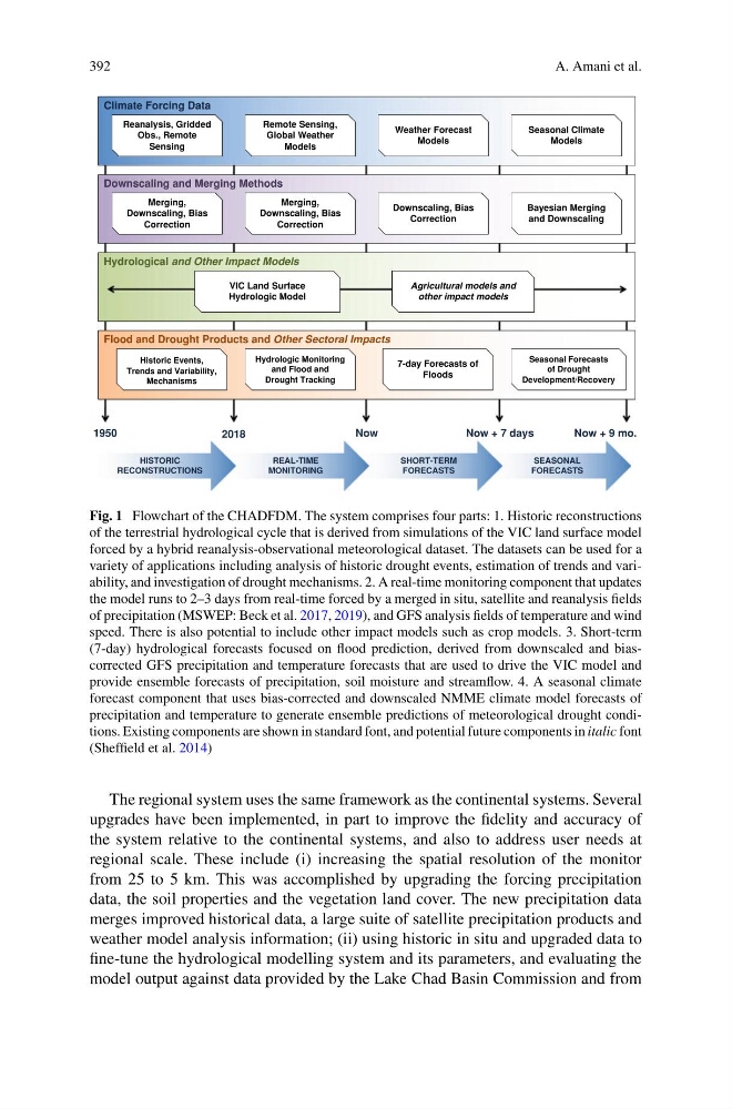
Fig. 1 Flowchart of the CHADFDM. The system comprises four parts: 1. Historic reconstructions
of the terrestrial hydrological cycle that is derived from simulations of the VIC land surface model
forced by a hybrid reanalysis-observational meteorological dataset. The datasets can be used for a
variety of applications including analysis of historic drought events, estimation of trends and variability, and investigation of drought mechanisms. 2. A real-time monitoring component that updates
the model runs to 2–3 days from real-time forced by a merged in situ, satellite and reanalysis fields
of precipitation (MSWEP: Beck et al. 2017, 2019), and GFS analysis fields of temperature and wind
speed. There is also potential to include other impact models such as crop models. 3. Short-term
(7-day) hydrological forecasts focused on flood prediction, derived from downscaled and biascorrected GFS precipitation and temperature forecasts that are used to drive the VIC model and
provide ensemble forecasts of precipitation, soil moisture and streamflow. 4. A seasonal climate
forecast component that uses bias-corrected and downscaled NMME climate model forecasts of
precipitation and temperature to generate ensemble predictions of meteorological drought conditions. Existing components are shown in standard font, and potential future components in italic font
(Sheffield et al. 2014)
The regional system uses the same framework as the continental systems. Several
upgrades have been implemented, in part to improve the fidelity and accuracy of
the system relative to the continental systems, and also to address user needs at
regional scale. These include (i) increasing the spatial resolution of the monitor
from 25 to 5 km. This was accomplished by upgrading the forcing precipitation
data, the soil properties and the vegetation land cover. The new precipitation data
merges improved historical data, a large suite of satellite precipitation products and
weather model analysis information; (ii) using historic in situ and upgraded data to
fine-tune the hydrological modelling system and its parameters, and evaluating the
model output against data provided by the Lake Chad Basin Commission and from
A. Amani et al.
Downscaling and Merging Methods
Hydrological and Other Impact Models
Flood and Drought Products and Other Sectoral Impacts
Climate Forcing Data
HISTORIC
RECONSTRUCTIONS
REAL-TIME
MONITORING
SEASONAL
FORECASTS
1950
2018
Now
Now + 9 mo.
Reanalysis, Gridded
Obs., Remote
Sensing
Remote Sensing,
Global Weather
Models
Seasonal Climate
Models
Merging,
Downscaling, Bias
Correction
Merging,
Downscaling, Bias
Correction
Downscaling, Bias
Correction
Historic Events,
Trends and Variability,
Mechanisms
Hydrologic Monitoring
and Flood and
Drought Tracking
Seasonal Forecasts
of Drought
Development/Recovery
Weather Forecast
Models
Bayesian Merging
and Downscaling
Now + 7 days
SHORT-TERM
FORECASTS
7-day Forecasts of
Floods
VIC Land Surface
Hydrologic Model
Agricultural models and
other impact models
Fig. 1 Flowchart of the CHADFDM. The system comprises four parts: 1. Historic reconstructions
of the terrestrial hydrological cycle that is derived from simulations of the VIC land surface model
forced by a hybrid reanalysis-observational meteorological dataset. The datasets can be used for a
variety of applications including analysis of historic drought events, estimation of trends and variability, and investigation of drought mechanisms. 2. A real-time monitoring component that updates
the model runs to 2–3 days from real-time forced by a merged in situ, satellite and reanalysis fields
of precipitation (MSWEP: Beck et al. 2017, 2019), and GFS analysis fields of temperature and wind
speed. There is also potential to include other impact models such as crop models. 3. Short-term
(7-day) hydrological forecasts focused on flood prediction, derived from downscaled and biascorrected GFS precipitation and temperature forecasts that are used to drive the VIC model and
provide ensemble forecasts of precipitation, soil moisture and streamflow. 4. A seasonal climate
forecast component that uses bias-corrected and downscaled NMME climate model forecasts of
precipitation and temperature to generate ensemble predictions of meteorological drought conditions. Existing components are shown in standard font, and potential future components in italic font
(Sheffield et al. 2014)
The regional system uses the same framework as the continental systems. Several
upgrades have been implemented, in part to improve the fidelity and accuracy of
the system relative to the continental systems, and also to address user needs at
regional scale. These include (i) increasing the spatial resolution of the monitor
from 25 to 5 km. This was accomplished by upgrading the forcing precipitation
data, the soil properties and the vegetation land cover. The new precipitation data
merges improved historical data, a large suite of satellite precipitation products and
weather model analysis information; (ii) using historic in situ and upgraded data to
fine-tune the hydrological modelling system and its parameters, and evaluating the
model output against data provided by the Lake Chad Basin Commission and from