

10 Hydrology and Climate Impacts on Streamflow and Sediment …
233
Table 1 Land-use changes in the Nyando River Basin for the years 2000 and 2015
Land Cover
2000
2015
Change (Area)
Change (%)
Cropland (km 2 )
2,760
2,727
−34
−1.2
Forestland (km 2 )
669
725
56
8
Grassland (km 2 )
156
162
6
3.8
Settlements (km 2 )
2
4
2
100
Wetlands (km 2 )
36
7
−29
−81.7
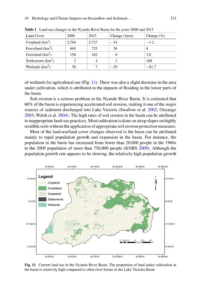
of wetlands for agricultural use (Fig. 11). There was also a slight decrease in the area
under cultivation, which is attributed to the impacts of flooding in the lower parts of
the basin.
Soil erosion is a serious problem in the Nyando River Basin. It is estimated that
60% of the basin is experiencing accelerated soil erosion, making it one of the major
sources of sediment discharged into Lake Victoria (Swallow et al. 2002; Onyango
2003; Walsh et al. 2004). The high rates of soil erosion in the basin can be attributed
to inappropriate land-use practices. Most cultivation is done on steep slopes on highly
erodible soils without the application of appropriate soil erosion protection measures.
Most of the land-use/land cover changes observed in the basin can be attributed
mainly to rapid population growth and expansion in the basin. For instance, the
population in the basin has increased from fewer than 20,000 people in the 1960s
to the 2009 population of more than 750,000 people (KNBS 2009). Although the
population growth rate appears to be slowing, the relatively high population growth
Fig. 11 Current land use in the Nyando River Basin. The proportion of land under cultivation in
the basin is relatively high compared to other river basins in the Lake Victoria Basin
233
Table 1 Land-use changes in the Nyando River Basin for the years 2000 and 2015
Land Cover
2000
2015
Change (Area)
Change (%)
Cropland (km 2 )
2,760
2,727
−34
−1.2
Forestland (km 2 )
669
725
56
8
Grassland (km 2 )
156
162
6
3.8
Settlements (km 2 )
2
4
2
100
Wetlands (km 2 )
36
7
−29
−81.7
of wetlands for agricultural use (Fig. 11). There was also a slight decrease in the area
under cultivation, which is attributed to the impacts of flooding in the lower parts of
the basin.
Soil erosion is a serious problem in the Nyando River Basin. It is estimated that
60% of the basin is experiencing accelerated soil erosion, making it one of the major
sources of sediment discharged into Lake Victoria (Swallow et al. 2002; Onyango
2003; Walsh et al. 2004). The high rates of soil erosion in the basin can be attributed
to inappropriate land-use practices. Most cultivation is done on steep slopes on highly
erodible soils without the application of appropriate soil erosion protection measures.
Most of the land-use/land cover changes observed in the basin can be attributed
mainly to rapid population growth and expansion in the basin. For instance, the
population in the basin has increased from fewer than 20,000 people in the 1960s
to the 2009 population of more than 750,000 people (KNBS 2009). Although the
population growth rate appears to be slowing, the relatively high population growth
Fig. 11 Current land use in the Nyando River Basin. The proportion of land under cultivation in
the basin is relatively high compared to other river basins in the Lake Victoria Basin