

180
M. O. Eduvie and I. F. Oseke
MAPE: 1.41428
MAD: 0.46335
MSD: 0.50300
Linear Trend Analysis Model
Yt =33.1264 + 5.49E-03*t
Trend
Fit
Time
Average
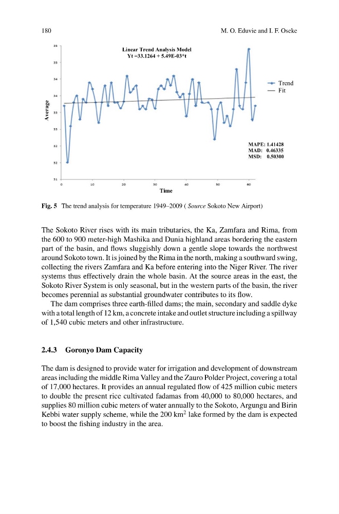
Fig. 5 The trend analysis for temperature 1949–2009 ( Source Sokoto New Airport)
The Sokoto River rises with its main tributaries, the Ka, Zamfara and Rima, from
the 600 to 900 meter-high Mashika and Dunia highland areas bordering the eastern
part of the basin, and flows sluggishly down a gentle slope towards the northwest
around Sokoto town. It is joined by the Rima in the north, making a southward swing,
collecting the rivers Zamfara and Ka before entering into the Niger River. The river
systems thus effectively drain the whole basin. At the source areas in the east, the
Sokoto River System is only seasonal, but in the western parts of the basin, the river
becomes perennial as substantial groundwater contributes to its flow.
The dam comprises three earth-filled dams; the main, secondary and saddle dyke
with a total length of 12 km, a concrete intake and outlet structure including a spillway
of 1,540 cubic meters and other infrastructure.
2.4.3 Goronyo Dam Capacity
The dam is designed to provide water for irrigation and development of downstream
areas including the middle Rima Valley and the Zauro Polder Project, covering a total
of 17,000 hectares. It provides an annual regulated flow of 425 million cubic meters
to double the present rice cultivated fadamas from 40,000 to 80,000 hectares, and
supplies 80 million cubic meters of water annually to the Sokoto, Argungu and Birin
Kebbi water supply scheme, while the 200 km
2 lake formed by the dam is expected
to boost the fishing industry in the area.
M. O. Eduvie and I. F. Oseke
MAPE: 1.41428
MAD: 0.46335
MSD: 0.50300
Linear Trend Analysis Model
Yt =33.1264 + 5.49E-03*t
Trend
Fit
Time
Average
Fig. 5 The trend analysis for temperature 1949–2009 ( Source Sokoto New Airport)
The Sokoto River rises with its main tributaries, the Ka, Zamfara and Rima, from
the 600 to 900 meter-high Mashika and Dunia highland areas bordering the eastern
part of the basin, and flows sluggishly down a gentle slope towards the northwest
around Sokoto town. It is joined by the Rima in the north, making a southward swing,
collecting the rivers Zamfara and Ka before entering into the Niger River. The river
systems thus effectively drain the whole basin. At the source areas in the east, the
Sokoto River System is only seasonal, but in the western parts of the basin, the river
becomes perennial as substantial groundwater contributes to its flow.
The dam comprises three earth-filled dams; the main, secondary and saddle dyke
with a total length of 12 km, a concrete intake and outlet structure including a spillway
of 1,540 cubic meters and other infrastructure.
2.4.3 Goronyo Dam Capacity
The dam is designed to provide water for irrigation and development of downstream
areas including the middle Rima Valley and the Zauro Polder Project, covering a total
of 17,000 hectares. It provides an annual regulated flow of 425 million cubic meters
to double the present rice cultivated fadamas from 40,000 to 80,000 hectares, and
supplies 80 million cubic meters of water annually to the Sokoto, Argungu and Birin
Kebbi water supply scheme, while the 200 km
2 lake formed by the dam is expected
to boost the fishing industry in the area.