

including coastal and sea animal species diversity (UNDP, UNEP, World Bank, and
World Resources Institute 2000). It is hypothesized that peat formation started from
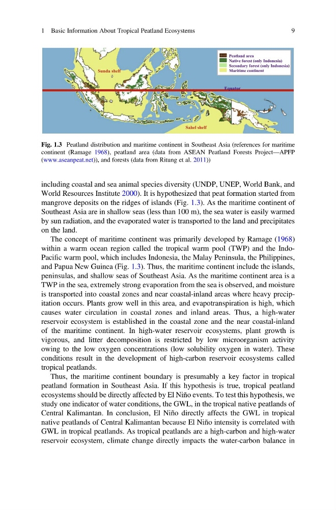
mangrove deposits on the ridges of islands (Fig. 1.3). As the maritime continent of
Southeast Asia are in shallow seas (less than 100 m), the sea water is easily warmed
by sun radiation, and the evaporated water is transported to the land and precipitates
on the land.
The concept of maritime continent was primarily developed by Ramage (1968)
within a warm ocean region called the tropical warm pool (TWP) and the IndoPacific warm pool, which includes Indonesia, the Malay Peninsula, the Philippines,
and Papua New Guinea (Fig. 1.3). Thus, the maritime continent include the islands,
peninsulas, and shallow seas of Southeast Asia. As the maritime continent area is a
TWP in the sea, extremely strong evaporation from the sea is observed, and moisture
is transported into coastal zones and near coastal-inland areas where heavy precipitation occurs. Plants grow well in this area, and evapotranspiration is high, which
causes water circulation in coastal zones and inland areas. Thus, a high-water
reservoir ecosystem is established in the coastal zone and the near coastal-inland
of the maritime continent. In high-water reservoir ecosystems, plant growth is
vigorous, and litter decomposition is restricted by low microorganism activity
owing to the low oxygen concentrations (low solubility oxygen in water). These
conditions result in the development of high-carbon reservoir ecosystems called
tropical peatlands.
Thus, the maritime continent boundary is presumably a key factor in tropical
peatland formation in Southeast Asia. If this hypothesis is true, tropical peatland
ecosystems should be directly affected by El Niño events. To test this hypothesis, we
study one indicator of water conditions, the GWL, in the tropical native peatlands of
Central Kalimantan. In conclusion, El Niño directly affects the GWL in tropical
native peatlands of Central Kalimantan because El Niño intensity is correlated with
GWL in tropical peatlands. As tropical peatlands are a high-carbon and high-water
reservoir ecosystem, climate change directly impacts the water-carbon balance in
Sunda shelf
Sahel shelf
Equator
Peatland area
Native forest (only Indonesia)
Secondary forest (only Indonesia)
Maritime continent
Fig. 1.3 Peatland distribution and maritime continent in Southeast Asia (references for maritime
continent (Ramage 1968), peatland area (data from ASEAN Peatland Forests Project—APFP
(www.aseanpeat.net)), and forests (data from Ritung et al. 2011))
1 Basic Information About Tropical Peatland Ecosystems
9
World Resources Institute 2000). It is hypothesized that peat formation started from
mangrove deposits on the ridges of islands (Fig. 1.3). As the maritime continent of
Southeast Asia are in shallow seas (less than 100 m), the sea water is easily warmed
by sun radiation, and the evaporated water is transported to the land and precipitates
on the land.
The concept of maritime continent was primarily developed by Ramage (1968)
within a warm ocean region called the tropical warm pool (TWP) and the IndoPacific warm pool, which includes Indonesia, the Malay Peninsula, the Philippines,
and Papua New Guinea (Fig. 1.3). Thus, the maritime continent include the islands,
peninsulas, and shallow seas of Southeast Asia. As the maritime continent area is a
TWP in the sea, extremely strong evaporation from the sea is observed, and moisture
is transported into coastal zones and near coastal-inland areas where heavy precipitation occurs. Plants grow well in this area, and evapotranspiration is high, which
causes water circulation in coastal zones and inland areas. Thus, a high-water
reservoir ecosystem is established in the coastal zone and the near coastal-inland
of the maritime continent. In high-water reservoir ecosystems, plant growth is
vigorous, and litter decomposition is restricted by low microorganism activity
owing to the low oxygen concentrations (low solubility oxygen in water). These
conditions result in the development of high-carbon reservoir ecosystems called
tropical peatlands.
Thus, the maritime continent boundary is presumably a key factor in tropical
peatland formation in Southeast Asia. If this hypothesis is true, tropical peatland
ecosystems should be directly affected by El Niño events. To test this hypothesis, we
study one indicator of water conditions, the GWL, in the tropical native peatlands of
Central Kalimantan. In conclusion, El Niño directly affects the GWL in tropical
native peatlands of Central Kalimantan because El Niño intensity is correlated with
GWL in tropical peatlands. As tropical peatlands are a high-carbon and high-water
reservoir ecosystem, climate change directly impacts the water-carbon balance in
Sunda shelf
Sahel shelf
Equator
Peatland area
Native forest (only Indonesia)
Secondary forest (only Indonesia)
Maritime continent
Fig. 1.3 Peatland distribution and maritime continent in Southeast Asia (references for maritime
continent (Ramage 1968), peatland area (data from ASEAN Peatland Forests Project—APFP
(www.aseanpeat.net)), and forests (data from Ritung et al. 2011))
1 Basic Information About Tropical Peatland Ecosystems
9