

492
F. Bordry et al.
8.9.3 Reference and Co-ordinate Systems
For the positioning of an object, one has to define a Reference system, a frame to
which the position and the orientation of the object are referenced. A co-ordinates
system is attached to this frame and defines the position of the object in units (m for
distances, gon for angles) and ways of describing the position (Polar or Cartesian
system).
At CERN, the reference system has evolved with the increase of the size of its
installations. At the epoch of the PS (50’s) and the ISR (60’s), the surface of the
earth could be considered as a plane without significant error. The XY plane adopted
was the plane of the PS synchrotron and a polar co-ordinate system was used. The
Z co-ordinate was the difference of height measured with respect to the XY plane.
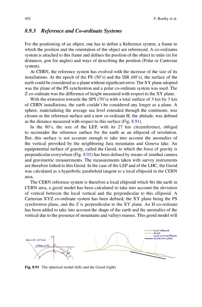
With the extension towards the SPS (70’s) with a total surface of 3 km by 3 km
of CERN installations, the earth couldn’t be considered any longer as a plane. A
sphere, materializing the average sea level extended through the continents, was
chosen as the reference surface and a new co-ordinate H, the altitude, was defined
as the distance measured with respect to this surface (Fig. 8.91).
In the 80’s, the size of the LEP, with its 27 km circumference, obliged
to reconsider the reference surface for the earth as an ellipsoid of revolution.
But, this surface is not accurate enough to take into account the anomalies of
the vertical provoked by the neighboring Jura mountains and Geneva lake. An
equipotential surface of gravity, called the Geoid, to which the force of gravity is
perpendicular everywhere (Fig. 8.92) has been defined by means of zenithal camera
and gravimetric measurements. The measurements taken with survey instruments
are therefore linked to this Geoid. In the case of the LEP and of the LHC, the Geoid
was calculated as a hyperbolic paraboloid tangent to a local ellipsoid in the CERN
area.
The CERN reference system is therefore a local ellipsoid which fits the earth in
CERN area, a geoid model has been calculated to take into account the deviation
of vertical between the local vertical and the perpendicular to this ellipsoid. A
Cartesian XYZ co-ordinate system has been defined; the XY plane being the PS
synchrotron plane, and the Z is perpendicular to the XY plane. An H co-ordinate
has been added to take into account the shape of the earth and the anomalies of the
vertical due to the presence of mountains and valleys masses. This geoid model will
Fig. 8.91 The spherical model (left) and the Geoid (right)
F. Bordry et al.
8.9.3 Reference and Co-ordinate Systems
For the positioning of an object, one has to define a Reference system, a frame to
which the position and the orientation of the object are referenced. A co-ordinates
system is attached to this frame and defines the position of the object in units (m for
distances, gon for angles) and ways of describing the position (Polar or Cartesian
system).
At CERN, the reference system has evolved with the increase of the size of its
installations. At the epoch of the PS (50’s) and the ISR (60’s), the surface of the
earth could be considered as a plane without significant error. The XY plane adopted
was the plane of the PS synchrotron and a polar co-ordinate system was used. The
Z co-ordinate was the difference of height measured with respect to the XY plane.
With the extension towards the SPS (70’s) with a total surface of 3 km by 3 km
of CERN installations, the earth couldn’t be considered any longer as a plane. A
sphere, materializing the average sea level extended through the continents, was
chosen as the reference surface and a new co-ordinate H, the altitude, was defined
as the distance measured with respect to this surface (Fig. 8.91).
In the 80’s, the size of the LEP, with its 27 km circumference, obliged
to reconsider the reference surface for the earth as an ellipsoid of revolution.
But, this surface is not accurate enough to take into account the anomalies of
the vertical provoked by the neighboring Jura mountains and Geneva lake. An
equipotential surface of gravity, called the Geoid, to which the force of gravity is
perpendicular everywhere (Fig. 8.92) has been defined by means of zenithal camera
and gravimetric measurements. The measurements taken with survey instruments
are therefore linked to this Geoid. In the case of the LEP and of the LHC, the Geoid
was calculated as a hyperbolic paraboloid tangent to a local ellipsoid in the CERN
area.
The CERN reference system is therefore a local ellipsoid which fits the earth in
CERN area, a geoid model has been calculated to take into account the deviation
of vertical between the local vertical and the perpendicular to this ellipsoid. A
Cartesian XYZ co-ordinate system has been defined; the XY plane being the PS
synchrotron plane, and the Z is perpendicular to the XY plane. An H co-ordinate
has been added to take into account the shape of the earth and the anomalies of the
vertical due to the presence of mountains and valleys masses. This geoid model will
Fig. 8.91 The spherical model (left) and the Geoid (right)