

(18,406 cumec) had occurred twice in August
1913 and August 1935 before the implementation of Damodar Valley Scheme. Examination of
actual inflow for the two terminal reservoirs at
Maithon and Panchet shows that major floods
nearing or exceeding this maximum observed
flow of 18,406 cumec occurred only in 1959,
1978 and 1995.
During 1959, the peak inflow into the reservoir was 17,641 cumec which was moderate to
8,155 cumec. However, the outflow from Durgapur Barrage was 9,911 cumec due to the
contribution from intermediate catchments. It has
been estimated by DVC that had there been no
dams, a flood of 22,937 cumec would have been
experienced below Durgapur which was much
higher than the highest record i.e. 18,406 cumec
till that date.
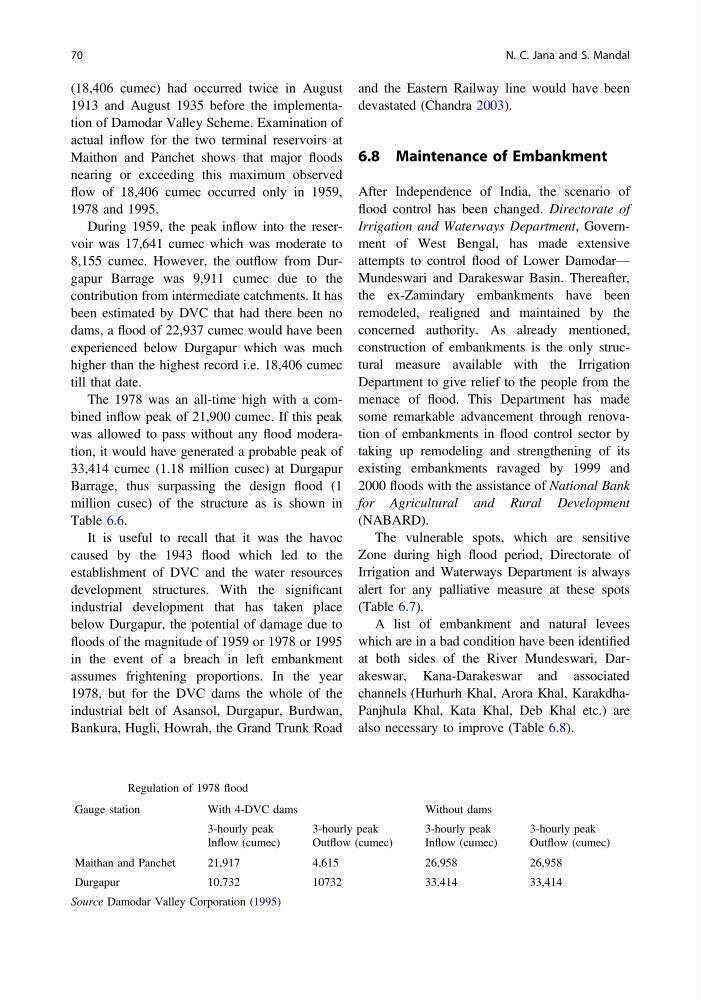
The 1978 was an all-time high with a combined inflow peak of 21,900 cumec. If this peak
was allowed to pass without any flood moderation, it would have generated a probable peak of
33,414 cumec (1.18 million cusec) at Durgapur
Barrage, thus surpassing the design flood (1
million cusec) of the structure as is shown in
Table 6.6.
It is useful to recall that it was the havoc
caused by the 1943 flood which led to the
establishment of DVC and the water resources
development structures. With the significant
industrial development that has taken place
below Durgapur, the potential of damage due to
floods of the magnitude of 1959 or 1978 or 1995
in the event of a breach in left embankment
assumes frightening proportions. In the year
1978, but for the DVC dams the whole of the
industrial belt of Asansol, Durgapur, Burdwan,
Bankura, Hugli, Howrah, the Grand Trunk Road
and the Eastern Railway line would have been
devastated (Chandra 2003).
6.8 Maintenance of Embankment
After Independence of India, the scenario of
flood control has been changed. Directorate of
Irrigation and Waterways Department, Government of West Bengal, has made extensive
attempts to control flood of Lower Damodar—
Mundeswari and Darakeswar Basin. Thereafter,
the ex-Zamindary embankments have been
remodeled, realigned and maintained by the
concerned authority. As already mentioned,
construction of embankments is the only structural measure available with the Irrigation
Department to give relief to the people from the
menace of flood. This Department has made
some remarkable advancement through renovation of embankments in flood control sector by
taking up remodeling and strengthening of its
existing embankments ravaged by 1999 and
2000 floods with the assistance of National Bank
for Agricultural and Rural Development
(NABARD).
The vulnerable spots, which are sensitive
Zone during high flood period, Directorate of
Irrigation and Waterways Department is always
alert for any palliative measure at these spots
(Table 6.7).
A list of embankment and natural levees
which are in a bad condition have been identified
at both sides of the River Mundeswari, Darakeswar, Kana-Darakeswar and associated
channels (Hurhurh Khal, Arora Khal, KarakdhaPanjhula Khal, Kata Khal, Deb Khal etc.) are
also necessary to improve (Table 6.8).
Table 6.6 Regulation of 1978 flood
Gauge station
With 4-DVC dams
Without dams
3-hourly peak
Inflow (cumec)
3-hourly peak
Outflow (cumec)
3-hourly peak
Inflow (cumec)
3-hourly peak
Outflow (cumec)
Maithan and Panchet
21,917
4,615
26,958
26,958
Durgapur
10,732
10732
33,414
33,414
Source Damodar Valley Corporation (1995)
70
N. C. Jana and S. Mandal
1913 and August 1935 before the implementation of Damodar Valley Scheme. Examination of
actual inflow for the two terminal reservoirs at
Maithon and Panchet shows that major floods
nearing or exceeding this maximum observed
flow of 18,406 cumec occurred only in 1959,
1978 and 1995.
During 1959, the peak inflow into the reservoir was 17,641 cumec which was moderate to
8,155 cumec. However, the outflow from Durgapur Barrage was 9,911 cumec due to the
contribution from intermediate catchments. It has
been estimated by DVC that had there been no
dams, a flood of 22,937 cumec would have been
experienced below Durgapur which was much
higher than the highest record i.e. 18,406 cumec
till that date.
The 1978 was an all-time high with a combined inflow peak of 21,900 cumec. If this peak
was allowed to pass without any flood moderation, it would have generated a probable peak of
33,414 cumec (1.18 million cusec) at Durgapur
Barrage, thus surpassing the design flood (1
million cusec) of the structure as is shown in
Table 6.6.
It is useful to recall that it was the havoc
caused by the 1943 flood which led to the
establishment of DVC and the water resources
development structures. With the significant
industrial development that has taken place
below Durgapur, the potential of damage due to
floods of the magnitude of 1959 or 1978 or 1995
in the event of a breach in left embankment
assumes frightening proportions. In the year
1978, but for the DVC dams the whole of the
industrial belt of Asansol, Durgapur, Burdwan,
Bankura, Hugli, Howrah, the Grand Trunk Road
and the Eastern Railway line would have been
devastated (Chandra 2003).
6.8 Maintenance of Embankment
After Independence of India, the scenario of
flood control has been changed. Directorate of
Irrigation and Waterways Department, Government of West Bengal, has made extensive
attempts to control flood of Lower Damodar—
Mundeswari and Darakeswar Basin. Thereafter,
the ex-Zamindary embankments have been
remodeled, realigned and maintained by the
concerned authority. As already mentioned,
construction of embankments is the only structural measure available with the Irrigation
Department to give relief to the people from the
menace of flood. This Department has made
some remarkable advancement through renovation of embankments in flood control sector by
taking up remodeling and strengthening of its
existing embankments ravaged by 1999 and
2000 floods with the assistance of National Bank
for Agricultural and Rural Development
(NABARD).
The vulnerable spots, which are sensitive
Zone during high flood period, Directorate of
Irrigation and Waterways Department is always
alert for any palliative measure at these spots
(Table 6.7).
A list of embankment and natural levees
which are in a bad condition have been identified
at both sides of the River Mundeswari, Darakeswar, Kana-Darakeswar and associated
channels (Hurhurh Khal, Arora Khal, KarakdhaPanjhula Khal, Kata Khal, Deb Khal etc.) are
also necessary to improve (Table 6.8).
Table 6.6 Regulation of 1978 flood
Gauge station
With 4-DVC dams
Without dams
3-hourly peak
Inflow (cumec)
3-hourly peak
Outflow (cumec)
3-hourly peak
Inflow (cumec)
3-hourly peak
Outflow (cumec)
Maithan and Panchet
21,917
4,615
26,958
26,958
Durgapur
10,732
10732
33,414
33,414
Source Damodar Valley Corporation (1995)
70
N. C. Jana and S. Mandal