

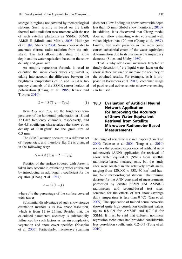
storage in regions not covered by meteorological
stations. Such sensing is based on the Earth
thermal radio radiation measurement with the use
of such satellite platforms as SSMR, SSM/I,
AMSR-E (Mitnik and Mitnik 2005; Hollinger
et al. 1990; Sharkov 2004). Snow cover is able to
attenuate thermal radio radiation from the substrate. This fact allows calculating the snow
depth and its water equivalent based on the snow
density and grain size.
An empiric regression formula is used to
calculate the snow cover water equivalent S,
taking into account the difference between the
brightness temperatures of 18 and 37 GHz frequency channels of the SSMR sensor horizontal
polarization (Chang et al. 1985; Kitaev and
Titkova 2010):
S ¼ 4:8 ðT 18h À T 37h Þ
ð 1Þ
Here T 18h and T 37h are the brightness temperatures of the horizontal polarization at 18 and
37 GHz frequency channels, respectively, and
the 4.8 coefficient characterizes the snow cover
density of 0.30 g/sm
3 for the grain size of
0.3 mm.
The SSM/I scanner operates on a different set
of frequencies, and therefore Eq. (1) is changed
in the following way:
S ¼ 4:8 ðT 19h À 5 À T 37h Þ
Fraction of the surface covered with forest is
taken into account in estimating water equivalent
by introducing an additional c coefficient for the
equation (Chang et al. 1987):
c ¼ 1=ð1 À f Þ
where f is the percentage of the surface covered
with forest.
Substantial disadvantage of such snow storage
estimation method is its low space resolution,
which is from 12 to 25 km. Besides that, the
calculated parameters accuracy is substantially
influenced by such factors as terrain complexity,
vegetation and snow cover specifics (Nosenko
et al. 2005). Particularly, microwave scanning
does not allow finding out snow cover with depth
less than 15 mm (Global snow monitoring 2010).
In addition, it is discovered that Chang model
does not allow estimating water equivalent with
values higher than 120 mm (Chang et al. 1987).
Finally, free water presence in the snow cover
causes substantial errors of the water equivalent
determination due to its microwave transparency
decrease (Stiles and Ulaby 1980).
That is why additional measures targeted at
timely detection of the liquid water layer on the
snow surface are used to increase the accuracy of
the obtained results. For example, as it is proposed in (Semmens et al. 2013), combined usage
of passive and active remote microwave sensing
can be used.
18.3 Evaluation of Artificial Neural
Network Application
for Improving the Accuracy
of Snow Water Equivalent
Retrieval from Satellite
Microwave Radiometer-Based
Measurements
The range of scientific research papers (Gan et al.
2009; Tedesco et al. 2004; Tong et al. 2010)
reviews the positive experience of artificial neural network (ANN) application for retrieval of
snow water equivalent (SWE) from satellite
radiometer-based measurements, but the study
sites were located in the relatively small areas,
ranging from 120,000 to 338,430 km
2 and having 3–12 meteorological stations. The training
datasets for the ANN consisted of measurements
performed by orbital SSM/I and AMSR-E
radiometers and ground-based test sites,
screened for the effects of wet snow (average
daily temperature is less than 0 °C) (Gan et al.
2009). The application of trained neural networks
showed quite high correlation coefficient values
up to 0.8–0.9 for AMSRE and 0.7–0.8 for
SSM/I. It must be said that different nonlinear
regression techniques had provided considerable
less correlation coefficients: 0.2–0.3 (Tong et al.
2010).
18 Development of the Approach for the Complex …
237
stations. Such sensing is based on the Earth
thermal radio radiation measurement with the use
of such satellite platforms as SSMR, SSM/I,
AMSR-E (Mitnik and Mitnik 2005; Hollinger
et al. 1990; Sharkov 2004). Snow cover is able to
attenuate thermal radio radiation from the substrate. This fact allows calculating the snow
depth and its water equivalent based on the snow
density and grain size.
An empiric regression formula is used to
calculate the snow cover water equivalent S,
taking into account the difference between the
brightness temperatures of 18 and 37 GHz frequency channels of the SSMR sensor horizontal
polarization (Chang et al. 1985; Kitaev and
Titkova 2010):
S ¼ 4:8 ðT 18h À T 37h Þ
ð 1Þ
Here T 18h and T 37h are the brightness temperatures of the horizontal polarization at 18 and
37 GHz frequency channels, respectively, and
the 4.8 coefficient characterizes the snow cover
density of 0.30 g/sm
3 for the grain size of
0.3 mm.
The SSM/I scanner operates on a different set
of frequencies, and therefore Eq. (1) is changed
in the following way:
S ¼ 4:8 ðT 19h À 5 À T 37h Þ
Fraction of the surface covered with forest is
taken into account in estimating water equivalent
by introducing an additional c coefficient for the
equation (Chang et al. 1987):
c ¼ 1=ð1 À f Þ
where f is the percentage of the surface covered
with forest.
Substantial disadvantage of such snow storage
estimation method is its low space resolution,
which is from 12 to 25 km. Besides that, the
calculated parameters accuracy is substantially
influenced by such factors as terrain complexity,
vegetation and snow cover specifics (Nosenko
et al. 2005). Particularly, microwave scanning
does not allow finding out snow cover with depth
less than 15 mm (Global snow monitoring 2010).
In addition, it is discovered that Chang model
does not allow estimating water equivalent with
values higher than 120 mm (Chang et al. 1987).
Finally, free water presence in the snow cover
causes substantial errors of the water equivalent
determination due to its microwave transparency
decrease (Stiles and Ulaby 1980).
That is why additional measures targeted at
timely detection of the liquid water layer on the
snow surface are used to increase the accuracy of
the obtained results. For example, as it is proposed in (Semmens et al. 2013), combined usage
of passive and active remote microwave sensing
can be used.
18.3 Evaluation of Artificial Neural
Network Application
for Improving the Accuracy
of Snow Water Equivalent
Retrieval from Satellite
Microwave Radiometer-Based
Measurements
The range of scientific research papers (Gan et al.
2009; Tedesco et al. 2004; Tong et al. 2010)
reviews the positive experience of artificial neural network (ANN) application for retrieval of
snow water equivalent (SWE) from satellite
radiometer-based measurements, but the study
sites were located in the relatively small areas,
ranging from 120,000 to 338,430 km
2 and having 3–12 meteorological stations. The training
datasets for the ANN consisted of measurements
performed by orbital SSM/I and AMSR-E
radiometers and ground-based test sites,
screened for the effects of wet snow (average
daily temperature is less than 0 °C) (Gan et al.
2009). The application of trained neural networks
showed quite high correlation coefficient values
up to 0.8–0.9 for AMSRE and 0.7–0.8 for
SSM/I. It must be said that different nonlinear
regression techniques had provided considerable
less correlation coefficients: 0.2–0.3 (Tong et al.
2010).
18 Development of the Approach for the Complex …
237