

ranging between 2200 and 2300 mm in the years
of normal rainfall. However, as 2005 was a year
of pronounced drought conditions of severe
nature with lower rainfall, the potential evapotranspiration was conversely much higher than
its average atmospheric demand.
Consequently, the lower rainfall coupled with
higher potential evapotranspiration led to a higher
aridity index than the average annual normal
rainfall years. In the equation of very low rainfall
and exceptionally high potential evapotranspiration, the annual aridity index was 96.875. Hence,
the year 2005 also experienced hyper-arid conditions for the consecutive second year.
Figure 17.5 demonstrates the geographical
area covered by 100 mm rainfall at the end of the
monsoon period. The isohyet represents the total
amount of rainfall of the year 2006. The 100 mm
isohyet covers a small area of Pokaran tehsil in
Jaisalmer district, Kolayat tehsil in Bikaner district, Bikaner tehsil and south-western parts of
Anupgarh tehsil of district Ganganagar.
The isohyet of 2006 is equal to the average
annual rainfall of the western strip of land along
Pokaran and Kolayat tehsils. In its northern half,
it depicts the below average rainfall. Hence, there
was a drought condition. Parts of Bikaner and
Anupgarh tehsils have an average annual rainfall
of 175 mm, but in the year 2000, these areas had
considerable drought with only 100 mm rainfall.
The southern half of the 100 mm isohyet area has
a normal rainfall. In the year 2006, the areas
depicted normal rainfall. No drought conditions
were noticed.
Figure 17.6 shows the geographical extent
covered by 2300 mm annual potential evapotranspiration for the year 2006. Most of these arid
areas have an average annual potential evapotranspiration of less than 2300 mm in the normal
seasonal conditions.
Hence, potential evapotranspiration in the
year 2006 was slightly above its average. The
resultant aridity index was 95.652 in the year
2006. It means that even the year 2006, with
almost normal rainfall just experienced the
hyper-arid conditions.
Figure 17.7 shows the geographical area
covered by 100 mm rainfall at the end of the
monsoon period. The isohyet represents total
annual rainfall of the year 2007. This 100 mm
low rainfall isohyet covers a small area of the
arid zone. It is confined to the western limit of
Jaisalmer. A very small area of lowest rainfall
indicates that rest of the Rajasthan had experienced good rainfall. Hence, the year 2007 was
not a scarcity rainfall or drought year.
Figure 17.8 illustrates the geographical extent
of potential evapotranspiration for the year 2007.
The most western extent of Jaisalmer records a
mean annual potential evapotranspiration of
slightly less than 2300 mm. The resultant aridity
index was again 95.652 in the year 2007 also. It
indicates that 2007 was also a just hyper-arid
year in this small area.
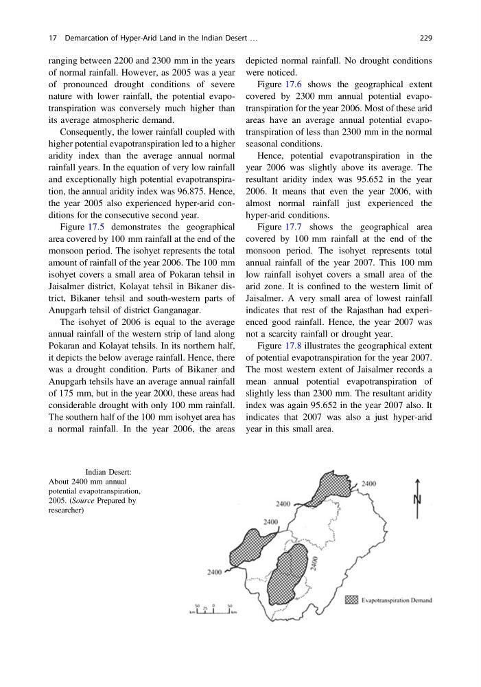
Fig. 17.4 Indian Desert:
About 2400 mm annual
potential evapotranspiration,
2005. (Source Prepared by
researcher)
17 Demarcation of Hyper-Arid Land in the Indian Desert …
229
of normal rainfall. However, as 2005 was a year
of pronounced drought conditions of severe
nature with lower rainfall, the potential evapotranspiration was conversely much higher than
its average atmospheric demand.
Consequently, the lower rainfall coupled with
higher potential evapotranspiration led to a higher
aridity index than the average annual normal
rainfall years. In the equation of very low rainfall
and exceptionally high potential evapotranspiration, the annual aridity index was 96.875. Hence,
the year 2005 also experienced hyper-arid conditions for the consecutive second year.
Figure 17.5 demonstrates the geographical
area covered by 100 mm rainfall at the end of the
monsoon period. The isohyet represents the total
amount of rainfall of the year 2006. The 100 mm
isohyet covers a small area of Pokaran tehsil in
Jaisalmer district, Kolayat tehsil in Bikaner district, Bikaner tehsil and south-western parts of
Anupgarh tehsil of district Ganganagar.
The isohyet of 2006 is equal to the average
annual rainfall of the western strip of land along
Pokaran and Kolayat tehsils. In its northern half,
it depicts the below average rainfall. Hence, there
was a drought condition. Parts of Bikaner and
Anupgarh tehsils have an average annual rainfall
of 175 mm, but in the year 2000, these areas had
considerable drought with only 100 mm rainfall.
The southern half of the 100 mm isohyet area has
a normal rainfall. In the year 2006, the areas
depicted normal rainfall. No drought conditions
were noticed.
Figure 17.6 shows the geographical extent
covered by 2300 mm annual potential evapotranspiration for the year 2006. Most of these arid
areas have an average annual potential evapotranspiration of less than 2300 mm in the normal
seasonal conditions.
Hence, potential evapotranspiration in the
year 2006 was slightly above its average. The
resultant aridity index was 95.652 in the year
2006. It means that even the year 2006, with
almost normal rainfall just experienced the
hyper-arid conditions.
Figure 17.7 shows the geographical area
covered by 100 mm rainfall at the end of the
monsoon period. The isohyet represents total
annual rainfall of the year 2007. This 100 mm
low rainfall isohyet covers a small area of the
arid zone. It is confined to the western limit of
Jaisalmer. A very small area of lowest rainfall
indicates that rest of the Rajasthan had experienced good rainfall. Hence, the year 2007 was
not a scarcity rainfall or drought year.
Figure 17.8 illustrates the geographical extent
of potential evapotranspiration for the year 2007.
The most western extent of Jaisalmer records a
mean annual potential evapotranspiration of
slightly less than 2300 mm. The resultant aridity
index was again 95.652 in the year 2007 also. It
indicates that 2007 was also a just hyper-arid
year in this small area.
Fig. 17.4 Indian Desert:
About 2400 mm annual
potential evapotranspiration,
2005. (Source Prepared by
researcher)
17 Demarcation of Hyper-Arid Land in the Indian Desert …
229