

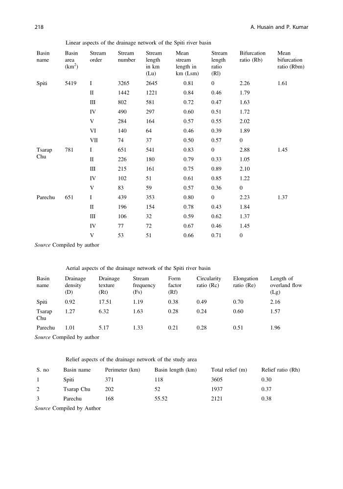
Table 16.2 Linear aspects of the drainage network of the Spiti river basin
Basin
name
Basin
area
(km
2
)
Stream
order
Stream
number
Stream
length
in km
(Lu)
Mean
stream
length in
km (Lsm)
Stream
length
ratio
(Rl)
Bifurcation
ratio (Rb)
Mean
bifurcation
ratio (Rbm)
Spiti
5419
I
3265
2645
0.81
0
2.26
1.61
II
1442
1221
0.84
0.46
1.79
III
802
581
0.72
0.47
1.63
IV
490
297
0.60
0.51
1.72
V
284
164
0.57
0.55
2.02
VI
140
64
0.46
0.39
1.89
VII
74
37
0.50
0.57
0
Tsarap
Chu
781
I
651
541
0.83
0
2.88
1.45
II
226
180
0.79
0.33
1.05
III
215
161
0.75
0.89
2.10
IV
102
51
0.61
0.85
1.22
V
83
59
0.57
0.36
0
Parechu
651
I
439
353
0.80
0
2.23
1.37
II
196
154
0.78
0.43
1.84
III
106
32
0.59
0.62
1.37
IV
77
72
0.67
0.46
1.45
V
53
51
0.66
0.71
0
Source Compiled by author
Table 16.3 Aerial aspects of the drainage network of the Spiti river basin
Basin
name
Drainage
density
(D)
Drainage
texture
(Rt)
Stream
frequency
(Fs)
Form
factor
(Rf)
Circularity
ratio (Rc)
Elongation
ratio (Re)
Length of
overland flow
(Lg)
Spiti
0.92
17.51
1.19
0.38
0.49
0.70
2.16
Tsarap
Chu
1.27
6.32
1.63
0.28
0.24
0.60
1.57
Parechu
1.01
5.17
1.33
0.21
0.28
0.51
1.96
Source Compiled by author
Table 16.4 Relief aspects of the drainage network of the study area
S. no
Basin name
Perimeter (km)
Basin length (km)
Total relief (m)
Relief ratio (Rh)
1
Spiti
371
118
3605
0.30
2
Tsarap Chu
202
52
1937
0.37
3
Parechu
168
55.52
2121
0.38
Source Compiled by Author
218
A. Husain and P. Kumar
Basin
name
Basin
area
(km
2
)
Stream
order
Stream
number
Stream
length
in km
(Lu)
Mean
stream
length in
km (Lsm)
Stream
length
ratio
(Rl)
Bifurcation
ratio (Rb)
Mean
bifurcation
ratio (Rbm)
Spiti
5419
I
3265
2645
0.81
0
2.26
1.61
II
1442
1221
0.84
0.46
1.79
III
802
581
0.72
0.47
1.63
IV
490
297
0.60
0.51
1.72
V
284
164
0.57
0.55
2.02
VI
140
64
0.46
0.39
1.89
VII
74
37
0.50
0.57
0
Tsarap
Chu
781
I
651
541
0.83
0
2.88
1.45
II
226
180
0.79
0.33
1.05
III
215
161
0.75
0.89
2.10
IV
102
51
0.61
0.85
1.22
V
83
59
0.57
0.36
0
Parechu
651
I
439
353
0.80
0
2.23
1.37
II
196
154
0.78
0.43
1.84
III
106
32
0.59
0.62
1.37
IV
77
72
0.67
0.46
1.45
V
53
51
0.66
0.71
0
Source Compiled by author
Table 16.3 Aerial aspects of the drainage network of the Spiti river basin
Basin
name
Drainage
density
(D)
Drainage
texture
(Rt)
Stream
frequency
(Fs)
Form
factor
(Rf)
Circularity
ratio (Rc)
Elongation
ratio (Re)
Length of
overland flow
(Lg)
Spiti
0.92
17.51
1.19
0.38
0.49
0.70
2.16
Tsarap
Chu
1.27
6.32
1.63
0.28
0.24
0.60
1.57
Parechu
1.01
5.17
1.33
0.21
0.28
0.51
1.96
Source Compiled by author
Table 16.4 Relief aspects of the drainage network of the study area
S. no
Basin name
Perimeter (km)
Basin length (km)
Total relief (m)
Relief ratio (Rh)
1
Spiti
371
118
3605
0.30
2
Tsarap Chu
202
52
1937
0.37
3
Parechu
168
55.52
2121
0.38
Source Compiled by Author
218
A. Husain and P. Kumar