

Maximum Drop ¼ Change in Z Value=Distance
à 100
The flow direction determines the natural
direction of drainage for every pixel in a digital
elevation model (DEM). Based on the output
flow direction map, the flow accumulation
operation counts the total number of pixels that
will drain into outlets (Fig. 16.2). The flow
accumulation tool calculates accumulated flow as
the accumulated weight of all cells flowing into
each down slope cell in the output raster.
16.5 Basin Delineation
In the present study, three different basins have
been delineated by using hydrological tool in the
ArcGIS 10.1. The three basins are named as
Spiti, Tsarap Chu and Parechu basins with an
area 5419, 781 and 651 sq. km, respectively. All
the three river basins, Spiti, Parechu and Tsarap
Chu, flow in the south-east, north-east and northwest direction, respectively (Fig. 16.3).
16.6 Results and Discussion
16.6.1 Linear Aspect
The linear aspects include stream order, stream
length, mean stream length, stream length ratio
and bifurcation ratio, and the results of the
analysis are given in Tables 16.2, 16.3 and 16.4.
16.6.1.1 Stream Order
The stream classification system developed by
Strahler (1964) has been adopted in the present
study. In the Strahler scheme for ordering the
network, all the “fingertips” tributaries are designated as first-order streams, and where two of
them join, they form a second-order stream.
Likewise, two second-order streams join to form
a third-order stream and so on, to the streams of
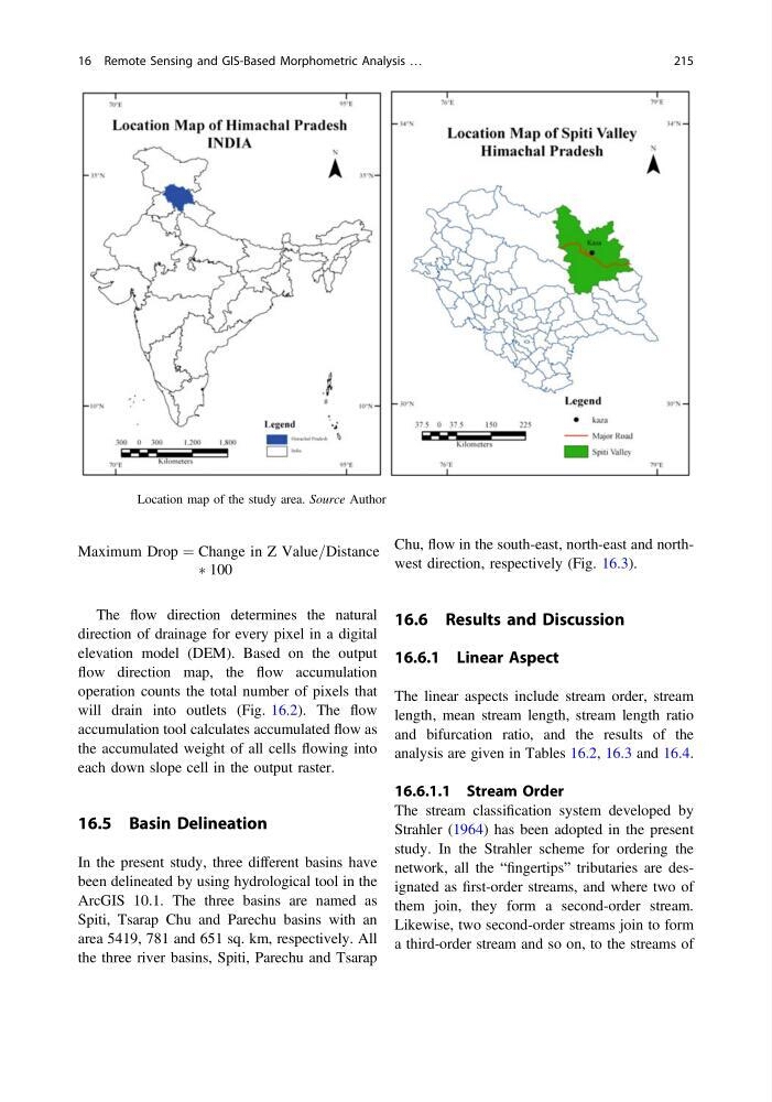
Fig. 16.1 Location map of the study area. Source Author
16 Remote Sensing and GIS-Based Morphometric Analysis …
215
à 100
The flow direction determines the natural
direction of drainage for every pixel in a digital
elevation model (DEM). Based on the output
flow direction map, the flow accumulation
operation counts the total number of pixels that
will drain into outlets (Fig. 16.2). The flow
accumulation tool calculates accumulated flow as
the accumulated weight of all cells flowing into
each down slope cell in the output raster.
16.5 Basin Delineation
In the present study, three different basins have
been delineated by using hydrological tool in the
ArcGIS 10.1. The three basins are named as
Spiti, Tsarap Chu and Parechu basins with an
area 5419, 781 and 651 sq. km, respectively. All
the three river basins, Spiti, Parechu and Tsarap
Chu, flow in the south-east, north-east and northwest direction, respectively (Fig. 16.3).
16.6 Results and Discussion
16.6.1 Linear Aspect
The linear aspects include stream order, stream
length, mean stream length, stream length ratio
and bifurcation ratio, and the results of the
analysis are given in Tables 16.2, 16.3 and 16.4.
16.6.1.1 Stream Order
The stream classification system developed by
Strahler (1964) has been adopted in the present
study. In the Strahler scheme for ordering the
network, all the “fingertips” tributaries are designated as first-order streams, and where two of
them join, they form a second-order stream.
Likewise, two second-order streams join to form
a third-order stream and so on, to the streams of
Fig. 16.1 Location map of the study area. Source Author
16 Remote Sensing and GIS-Based Morphometric Analysis …
215