

region of India where climate change and variability would adversely affect the water and food
security of the densely populated basin.
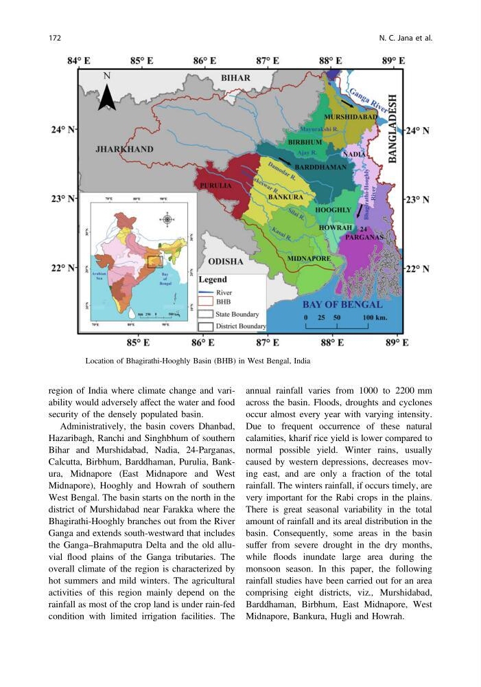
Administratively, the basin covers Dhanbad,
Hazaribagh, Ranchi and Singhbhum of southern
Bihar and Murshidabad, Nadia, 24-Parganas,
Calcutta, Birbhum, Barddhaman, Purulia, Bankura, Midnapore (East Midnapore and West
Midnapore), Hooghly and Howrah of southern
West Bengal. The basin starts on the north in the
district of Murshidabad near Farakka where the
Bhagirathi-Hooghly branches out from the River
Ganga and extends south-westward that includes
the Ganga–Brahmaputra Delta and the old alluvial flood plains of the Ganga tributaries. The
overall climate of the region is characterized by
hot summers and mild winters. The agricultural
activities of this region mainly depend on the
rainfall as most of the crop land is under rain-fed
condition with limited irrigation facilities. The
annual rainfall varies from 1000 to 2200 mm
across the basin. Floods, droughts and cyclones
occur almost every year with varying intensity.
Due to frequent occurrence of these natural
calamities, kharif rice yield is lower compared to
normal possible yield. Winter rains, usually
caused by western depressions, decreases moving east, and are only a fraction of the total
rainfall. The winters rainfall, if occurs timely, are
very important for the Rabi crops in the plains.
There is great seasonal variability in the total
amount of rainfall and its areal distribution in the
basin. Consequently, some areas in the basin
suffer from severe drought in the dry months,
while floods inundate large area during the
monsoon season. In this paper, the following
rainfall studies have been carried out for an area
comprising eight districts, viz., Murshidabad,
Barddhaman, Birbhum, East Midnapore, West
Midnapore, Bankura, Hugli and Howrah.
Fig. 13.1 Location of Bhagirathi-Hooghly Basin (BHB) in West Bengal, India
172
N. C. Jana et al.
security of the densely populated basin.
Administratively, the basin covers Dhanbad,
Hazaribagh, Ranchi and Singhbhum of southern
Bihar and Murshidabad, Nadia, 24-Parganas,
Calcutta, Birbhum, Barddhaman, Purulia, Bankura, Midnapore (East Midnapore and West
Midnapore), Hooghly and Howrah of southern
West Bengal. The basin starts on the north in the
district of Murshidabad near Farakka where the
Bhagirathi-Hooghly branches out from the River
Ganga and extends south-westward that includes
the Ganga–Brahmaputra Delta and the old alluvial flood plains of the Ganga tributaries. The
overall climate of the region is characterized by
hot summers and mild winters. The agricultural
activities of this region mainly depend on the
rainfall as most of the crop land is under rain-fed
condition with limited irrigation facilities. The
annual rainfall varies from 1000 to 2200 mm
across the basin. Floods, droughts and cyclones
occur almost every year with varying intensity.
Due to frequent occurrence of these natural
calamities, kharif rice yield is lower compared to
normal possible yield. Winter rains, usually
caused by western depressions, decreases moving east, and are only a fraction of the total
rainfall. The winters rainfall, if occurs timely, are
very important for the Rabi crops in the plains.
There is great seasonal variability in the total
amount of rainfall and its areal distribution in the
basin. Consequently, some areas in the basin
suffer from severe drought in the dry months,
while floods inundate large area during the
monsoon season. In this paper, the following
rainfall studies have been carried out for an area
comprising eight districts, viz., Murshidabad,
Barddhaman, Birbhum, East Midnapore, West
Midnapore, Bankura, Hugli and Howrah.
Fig. 13.1 Location of Bhagirathi-Hooghly Basin (BHB) in West Bengal, India
172
N. C. Jana et al.