

16 Water Management in the Pomeranian Rivers Estuary Zone …
313
16.4 Factors of Water Level Variation
A key role in forming the water conditions of the Pomeranian rivers, and especially
their estuary sections, is played by the main (Baltic Sea) and regional (coastal lakes)
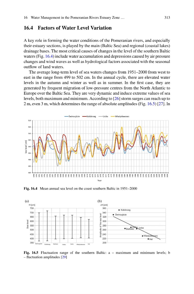
drainage bases. The most critical causes of changes in the level of the southern Baltic
waters (Fig. 16.4) include water accumulation and depressions caused by air pressure
changes and wind waves as well as hydrological factors associated with the seasonal
outflow of land waters.
The average long-term level of sea waters changes from 1951–2000 from west to
east in the range from 499 to 502 cm. In the annual cycle, there are elevated water
levels in the autumn and winter as well as in summer. In the first case, they are
generated by frequent migration of low-pressure centres from the North Atlantic to
Europe over the Baltic Sea. They are very dynamic and induce extreme values of sea
levels, both maximum and minimum. According to [26] storm surges can reach up to
2 m, even 3 m, which determines the range of absolute amplitudes (Fig. 16.5) [27]. In
480
485
490
495
500
505
510
515
520
1950
1951
1952
1953
1954
1955
1956
1957
1958
1959
1960
1961
1962
1963
1964
1965
1966
1967
1968
1969
1970
1971
1972
1973
1974
1975
1976
1977
1978
1979
1980
1981
1982
1983
1984
1985
1986
1987
1988
1989
1990
1991
1992
1993
1994
1995
1996
1997
1998
1999
2000
Sea level [cm]
Year
Świnoujście
Kołobrzeg
Ustka
Władysławowo
Fig. 16.4 Mean annual sea level on the coast southern Baltic in 1951–2000
(a)
(b)
Fig. 16.5 Fluctuation range of the southern Baltic: a – maximum and minimum levels; b
– fluctuation amplitudes [29]
313
16.4 Factors of Water Level Variation
A key role in forming the water conditions of the Pomeranian rivers, and especially
their estuary sections, is played by the main (Baltic Sea) and regional (coastal lakes)
drainage bases. The most critical causes of changes in the level of the southern Baltic
waters (Fig. 16.4) include water accumulation and depressions caused by air pressure
changes and wind waves as well as hydrological factors associated with the seasonal
outflow of land waters.
The average long-term level of sea waters changes from 1951–2000 from west to
east in the range from 499 to 502 cm. In the annual cycle, there are elevated water
levels in the autumn and winter as well as in summer. In the first case, they are
generated by frequent migration of low-pressure centres from the North Atlantic to
Europe over the Baltic Sea. They are very dynamic and induce extreme values of sea
levels, both maximum and minimum. According to [26] storm surges can reach up to
2 m, even 3 m, which determines the range of absolute amplitudes (Fig. 16.5) [27]. In
480
485
490
495
500
505
510
515
520
1950
1951
1952
1953
1954
1955
1956
1957
1958
1959
1960
1961
1962
1963
1964
1965
1966
1967
1968
1969
1970
1971
1972
1973
1974
1975
1976
1977
1978
1979
1980
1981
1982
1983
1984
1985
1986
1987
1988
1989
1990
1991
1992
1993
1994
1995
1996
1997
1998
1999
2000
Sea level [cm]
Year
Świnoujście
Kołobrzeg
Ustka
Władysławowo
Fig. 16.4 Mean annual sea level on the coast southern Baltic in 1951–2000
(a)
(b)
Fig. 16.5 Fluctuation range of the southern Baltic: a – maximum and minimum levels; b
– fluctuation amplitudes [29]