

1.3 Water Resources
13
1.3 Water Resources
1.3.1 Surface Water Resources
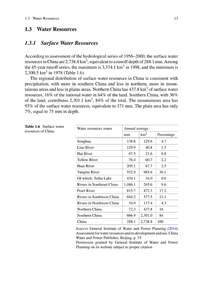
According to assessment of the hydrological series of 1956–2000, the surface water
resources in China are 2,738.8 km
3 , equivalent to a runoff depth of 288.1 mm. Among
the 45-year runoff series, the maximum is 3,374.1 km
3 in 1998, and the minimum is
2,300.5 km
3 in 1978 (Table 1.6).
The regional distribution of surface water resources in China is consistent with
precipitation, with more in southern China and less in northern, more in mountainous areas and less in plains areas. Northern China has 437.8 km
3 of surface water
resources, 16% of the national water in 64% of the land. Southern China, with 36%
of the land, contributes 2,301.1 km
3 , 84% of the total. The mountainous area has
93% of the surface water resources, equivalent to 371 mm. The plain area has only
7%, equal to 75 mm in depth.
Table 1.6 Surface water
resources of China
Water resources zones
Annual average
mm
km 3
Percentage
Songhua
138.6
129.6
4.7
Liao River
129.9
40.8
1.5
Hai River
67.5
21.6
0.8
Yellow River
76.4
60.7
2.2
Huai River
205.1
67.7
2.5
Yangtze River
552.9
985.6
36.1
Of which: Taihu Lake
434.1
16.0
0.6
Rivers in Southeast China
1,086.1
265.6
9.6
Pearl River
815.7
472.3
17.2
Rivers in Southwest China
684.2
577.5
21.1
Rivers in Northwest China
34.9
117.4
4.3
Northern China
72.3
437.8
16
Southern China
666.9 2,301.0
84
China
288.1 2,738.8 100
Sources General Institute of Water and Power Planning (2014)
Assessment for water resources and its development and use. China
Water and Power Publisher, Beijing, p. 55
Permission granted by General Institute of Water and Power
Planning on its website subject to proper citation
13
1.3 Water Resources
1.3.1 Surface Water Resources
According to assessment of the hydrological series of 1956–2000, the surface water
resources in China are 2,738.8 km
3 , equivalent to a runoff depth of 288.1 mm. Among
the 45-year runoff series, the maximum is 3,374.1 km
3 in 1998, and the minimum is
2,300.5 km
3 in 1978 (Table 1.6).
The regional distribution of surface water resources in China is consistent with
precipitation, with more in southern China and less in northern, more in mountainous areas and less in plains areas. Northern China has 437.8 km
3 of surface water
resources, 16% of the national water in 64% of the land. Southern China, with 36%
of the land, contributes 2,301.1 km
3 , 84% of the total. The mountainous area has
93% of the surface water resources, equivalent to 371 mm. The plain area has only
7%, equal to 75 mm in depth.
Table 1.6 Surface water
resources of China
Water resources zones
Annual average
mm
km 3
Percentage
Songhua
138.6
129.6
4.7
Liao River
129.9
40.8
1.5
Hai River
67.5
21.6
0.8
Yellow River
76.4
60.7
2.2
Huai River
205.1
67.7
2.5
Yangtze River
552.9
985.6
36.1
Of which: Taihu Lake
434.1
16.0
0.6
Rivers in Southeast China
1,086.1
265.6
9.6
Pearl River
815.7
472.3
17.2
Rivers in Southwest China
684.2
577.5
21.1
Rivers in Northwest China
34.9
117.4
4.3
Northern China
72.3
437.8
16
Southern China
666.9 2,301.0
84
China
288.1 2,738.8 100
Sources General Institute of Water and Power Planning (2014)
Assessment for water resources and its development and use. China
Water and Power Publisher, Beijing, p. 55
Permission granted by General Institute of Water and Power
Planning on its website subject to proper citation