

8.2 Groundwater Management System in China
187
The MWR groundwater function zone seeks to regionalize groundwater function
areas based on the resource’s principal functions, according to the natural and environmental characteristics, the strategic allocation of groundwater resources (in terms
of development and protection), and the environmental protection target. The zone
is used to coordinate the social and economic requirements for groundwater and to
allocate river basin and regional water resources (Department of Water Resources,
MWR 2005).
The zoning process involves analyzing existinggroundwater resources development and its problems and defining the future development and protection objectives
of the zone, including establishing the development cap, the water quality protection
target to provide safe water supply, and the groundwater control level to maintain
sustainable yield.
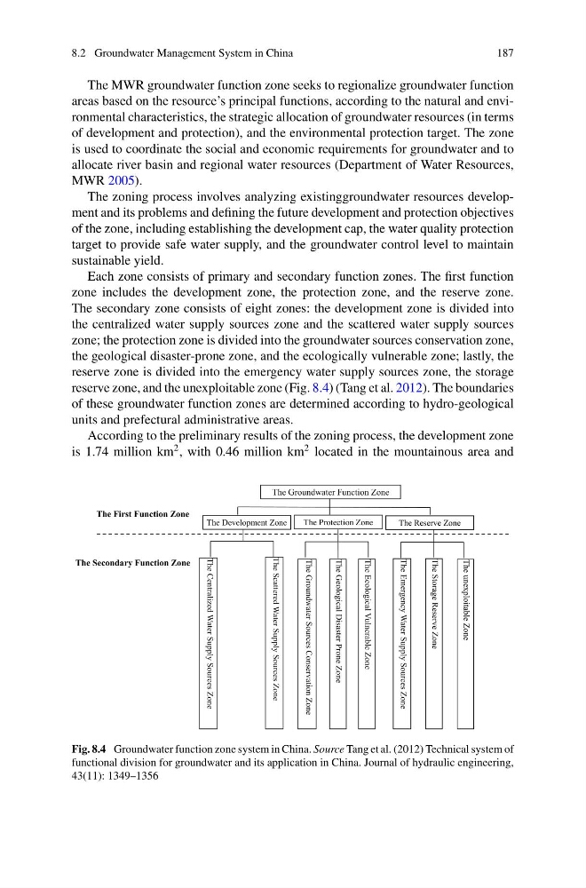
Each zone consists of primary and secondary function zones. The first function
zone includes the development zone, the protection zone, and the reserve zone.
The secondary zone consists of eight zones: the development zone is divided into
the centralized water supply sources zone and the scattered water supply sources
zone; the protection zone is divided into the groundwater sources conservation zone,
the geological disaster-prone zone, and the ecologically vulnerable zone; lastly, the
reserve zone is divided into the emergency water supply sources zone, the storage
reserve zone, and the unexploitable zone (Fig. 8.4) (Tang et al. 2012). The boundaries
of these groundwater function zones are determined according to hydro-geological
units and prefectural administrative areas.
According to the preliminary results of the zoning process, the development zone
is 1.74 million km
2 , with 0.46 million km
2 located in the mountainous area and
The First Function Zone
The Secondary Function Zone
The Centralized Water Supply Sources Zone
The Scattered Water Supply Sources Zone
The Groundwater Sources Conservation Zone
The Ecological Vulnerable Zone
The Emergency Water Supply Sources Zone
The unexploitable Zone
The Geological Disaster Prone Zone
The Storage Reserve Zone
The Groundwater Function Zone
The Development Zone
The Protection Zone
The Reserve Zone
Fig. 8.4 Groundwater function zone system in China. Source Tang et al. (2012) Technical system of
functional division for groundwater and its application in China. Journal of hydraulic engineering,
43(11): 1349–1356
187
The MWR groundwater function zone seeks to regionalize groundwater function
areas based on the resource’s principal functions, according to the natural and environmental characteristics, the strategic allocation of groundwater resources (in terms
of development and protection), and the environmental protection target. The zone
is used to coordinate the social and economic requirements for groundwater and to
allocate river basin and regional water resources (Department of Water Resources,
MWR 2005).
The zoning process involves analyzing existinggroundwater resources development and its problems and defining the future development and protection objectives
of the zone, including establishing the development cap, the water quality protection
target to provide safe water supply, and the groundwater control level to maintain
sustainable yield.
Each zone consists of primary and secondary function zones. The first function
zone includes the development zone, the protection zone, and the reserve zone.
The secondary zone consists of eight zones: the development zone is divided into
the centralized water supply sources zone and the scattered water supply sources
zone; the protection zone is divided into the groundwater sources conservation zone,
the geological disaster-prone zone, and the ecologically vulnerable zone; lastly, the
reserve zone is divided into the emergency water supply sources zone, the storage
reserve zone, and the unexploitable zone (Fig. 8.4) (Tang et al. 2012). The boundaries
of these groundwater function zones are determined according to hydro-geological
units and prefectural administrative areas.
According to the preliminary results of the zoning process, the development zone
is 1.74 million km
2 , with 0.46 million km
2 located in the mountainous area and
The First Function Zone
The Secondary Function Zone
The Centralized Water Supply Sources Zone
The Scattered Water Supply Sources Zone
The Groundwater Sources Conservation Zone
The Ecological Vulnerable Zone
The Emergency Water Supply Sources Zone
The unexploitable Zone
The Geological Disaster Prone Zone
The Storage Reserve Zone
The Groundwater Function Zone
The Development Zone
The Protection Zone
The Reserve Zone
Fig. 8.4 Groundwater function zone system in China. Source Tang et al. (2012) Technical system of
functional division for groundwater and its application in China. Journal of hydraulic engineering,
43(11): 1349–1356