

the residential landscape within the city is not homogeneous. Some districts mostly
have detached houses, whereas others contain many apartment buildings. Moreover,
the density of buildings and shape of city blocks differ by area. Earlier studies reveal
that these physical differences in the built environment are correlated with the
behavioral patterns and social class of the area’s inhabitants (Handy et al. 2002;
De Keersmaecker 2003; Wang et al. 2011). For example, in Jakarta, residential areas
comprising large, single-family houses developed by real estate companies tend to
attract middle- and upper-class citizens to the suburb (Winarso and Firman 2002;
Firman 2004; Arai 2012), and this trend will increase the energy consumption (such
as through the use of air conditioners) due to the large floor size (Permana et al.
2008). In these residential areas, it will be efficient to promote the use of renewable
energy or a passive cooling system to reduce the global environmental impact. In
contrast, lower-class citizens are more likely to inhabit densely populated areas
comprising small buildings, often considered slums. In these areas, the government
should prioritize solving social issues such as poverty, public health, and other social
services. To achieve the Sustainable Development Goals (SDGs), we must address
not only environmental problems but also social and economic issues (United
Nations 2015). Since the targeted problems are different for each type of residential
area, policies should be implemented based on the diversity of the residential
landscape to achieve sustainable development in its three dimensions—economic,
social, and environmental—in a balanced and integrated manner.
The classification of residential areas is an effective method to clarify the diversity of a city’s residential landscape. By categorizing the residential areas with
similar characteristics, we can clarify their differences and commonalities. Some
researchers have conducted such residential classification in developed countries
(Koizumi and Manabe 2001; De Keersmaecker 2003). However, an effective universal methodology to classify all the world’s cities is yet to be developed. For
example, in Japan, “district classification,” which categorizes the residential areas
within a city based on the proportion of wooden buildings, building coverage ratio,
pavement ratio, and other physical conditions, is used in the field of urban planning
(Takamizawa 1988; Koizumi and Manabe 2001). However, since this method is
specific to Japan, some of its indicators are tailored to the conditions of Japanese
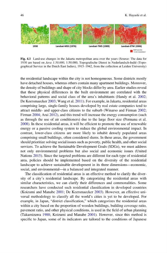
Fig. 4.1 Land-use changes in the Jakarta metropolitan area over the years (Source: The data for
1930 are based on Java 1:50.000, 1:50.000, Topografische Dienst in Nederlandsch-Indië (Topographical Service in the Dutch East Indies), 1915–1942, from the collection at Leiden University)
46
K. Hayashi et al.
have detached houses, whereas others contain many apartment buildings. Moreover,
the density of buildings and shape of city blocks differ by area. Earlier studies reveal
that these physical differences in the built environment are correlated with the
behavioral patterns and social class of the area’s inhabitants (Handy et al. 2002;
De Keersmaecker 2003; Wang et al. 2011). For example, in Jakarta, residential areas
comprising large, single-family houses developed by real estate companies tend to
attract middle- and upper-class citizens to the suburb (Winarso and Firman 2002;
Firman 2004; Arai 2012), and this trend will increase the energy consumption (such
as through the use of air conditioners) due to the large floor size (Permana et al.
2008). In these residential areas, it will be efficient to promote the use of renewable
energy or a passive cooling system to reduce the global environmental impact. In
contrast, lower-class citizens are more likely to inhabit densely populated areas
comprising small buildings, often considered slums. In these areas, the government
should prioritize solving social issues such as poverty, public health, and other social
services. To achieve the Sustainable Development Goals (SDGs), we must address
not only environmental problems but also social and economic issues (United
Nations 2015). Since the targeted problems are different for each type of residential
area, policies should be implemented based on the diversity of the residential
landscape to achieve sustainable development in its three dimensions—economic,
social, and environmental—in a balanced and integrated manner.
The classification of residential areas is an effective method to clarify the diversity of a city’s residential landscape. By categorizing the residential areas with
similar characteristics, we can clarify their differences and commonalities. Some
researchers have conducted such residential classification in developed countries
(Koizumi and Manabe 2001; De Keersmaecker 2003). However, an effective universal methodology to classify all the world’s cities is yet to be developed. For
example, in Japan, “district classification,” which categorizes the residential areas
within a city based on the proportion of wooden buildings, building coverage ratio,
pavement ratio, and other physical conditions, is used in the field of urban planning
(Takamizawa 1988; Koizumi and Manabe 2001). However, since this method is
specific to Japan, some of its indicators are tailored to the conditions of Japanese
Fig. 4.1 Land-use changes in the Jakarta metropolitan area over the years (Source: The data for
1930 are based on Java 1:50.000, 1:50.000, Topografische Dienst in Nederlandsch-Indië (Topographical Service in the Dutch East Indies), 1915–1942, from the collection at Leiden University)
46
K. Hayashi et al.