

27
Fifty-nine percent area of India is vulnerable to seismic damage, 68% area is
susceptible to draught, 8% area is prone to flood and 76% of the total coastline of
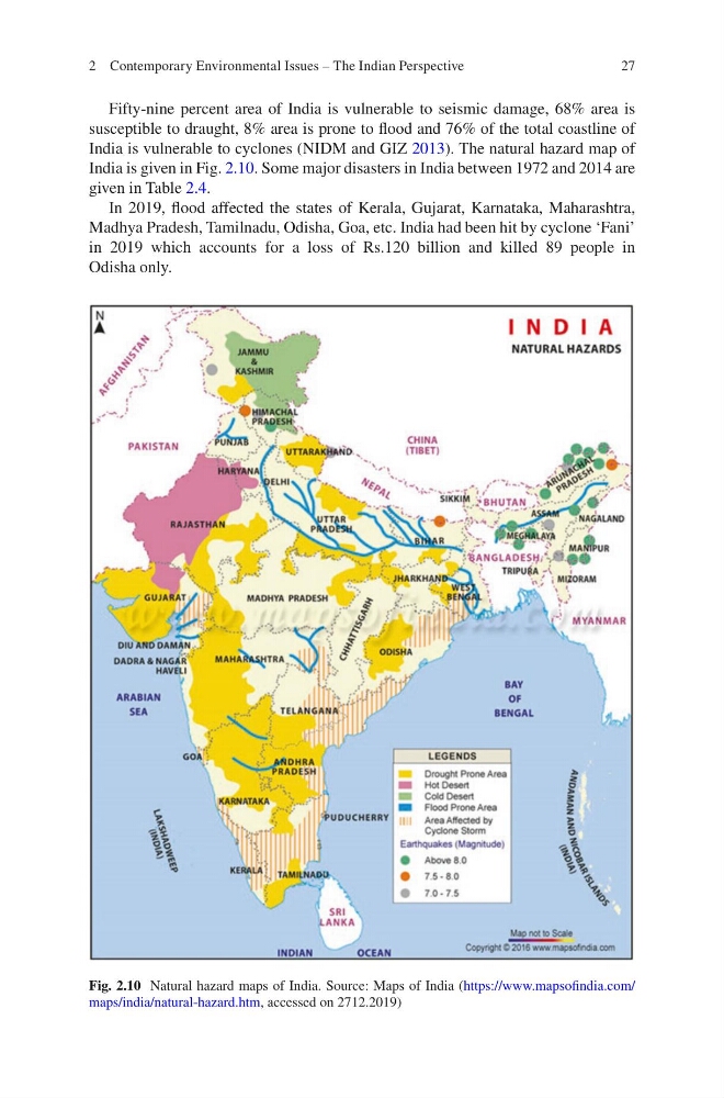
India is vulnerable to cyclones (NIDM and GIZ 2013). The natural hazard map of
India is given in Fig. 2.10. Some major disasters in India between 1972 and 2014 are
given in Table 2.4.
In 2019, flood affected the states of Kerala, Gujarat, Karnataka, Maharashtra,
Madhya Pradesh, Tamilnadu, Odisha, Goa, etc. India had been hit by cyclone ‘Fani’
in 2019 which accounts for a loss of Rs.120 billion and killed 89 people in
Odisha only.
Fig. 2.10 Natural hazard maps of India. Source: Maps of India (https://www.mapsofindia.com/
maps/india/natural-hazard.htm, accessed on 2712.2019)
2 Contemporary Environmental Issues – The Indian Perspective
Fifty-nine percent area of India is vulnerable to seismic damage, 68% area is
susceptible to draught, 8% area is prone to flood and 76% of the total coastline of
India is vulnerable to cyclones (NIDM and GIZ 2013). The natural hazard map of
India is given in Fig. 2.10. Some major disasters in India between 1972 and 2014 are
given in Table 2.4.
In 2019, flood affected the states of Kerala, Gujarat, Karnataka, Maharashtra,
Madhya Pradesh, Tamilnadu, Odisha, Goa, etc. India had been hit by cyclone ‘Fani’
in 2019 which accounts for a loss of Rs.120 billion and killed 89 people in
Odisha only.
Fig. 2.10 Natural hazard maps of India. Source: Maps of India (https://www.mapsofindia.com/
maps/india/natural-hazard.htm, accessed on 2712.2019)
2 Contemporary Environmental Issues – The Indian Perspective