

259
the 20 years of study period, it was identified that the most acutely drought-affected
blocks in Purulia were Jhalda-I, II, Joypur, Arsha and Bagmundi. In Bankura too the
chronic drought-prone blocks were positioned in the northern and eastern margins,
namely, Joypur, Kotulpur, Indus, Patrasayer, Sonamukhi and Barjora. Similarly in
Purba Medinipur district, the coastal blocks of Khejuri-II, Nandigram-I, Haldia and
Sutahata are identified to be perennially drought prone. Likewise, Garhbeta-I, II, III,
Salboni, Midnapore, Jhargram, Sankrail and Gobiballavpur blocks in Paschim
Medinipur were categorized to be severely affected by drought through the present
analysis. This would henceforth help in the process of decision-making to mitigate
the impacts of sparse rainfall as well as chalk out resilient techniques for combating
effects of drought in these targeted regions. An early or real-time assessment of RAI
and VCI would help in identification of water-stressed blocks and thus would enable
decision-makers and farmers in remodeling crop calendars accordingly, promoting
as well as using drought-resistant variety of seeds, modifying crop prices, formulating crop insurances, using water harvesting techniques, and managing available
water resources in these areas sustainably to prevent crop failures.
References
AMS (1997) Meteorological drought — policy statement. Bull Am Meteorol Soc 78:847–849
Baik J, Zohaib M, Kim U, Aadil M, Choi M (2019) Agricultural drought assessment based
on multiple soil moisture products. J Arid Environ 167:43–55. https://doi.org/10.1016/j.
jaridenv.2019.04.007
Bandyopadhyay S, Kar NS, Das S, Sen J (2014) River systems and water resources of West Bengal:
a review. Geol Soc India Spec Publ 3:63–84
Barring L, Hulme M (1991) Filters and approximate confidence intervals for
interpreting rainfall anomaly indices. J Clim 4:837–847. https://doi.org/
10.1175/1520-0442(1991)004<0837:FAACIF>2.0.CO;2
Bera K, Bandyopadhyay J (2017) Drought analysis for agricultural impact through geoinformatics based indices, a case study of Bankura District, West Bengal India. J Remote Sens GIS 6.
https://doi.org/10.4172/2469-4134.1000209
-2.50
-2.00
-1.50
-1.00
-0.50
0.00
0.50
1.00
1.50
1999-00
2000-01
2001-02
2002-03
2003-04
2004-05
2005-06
2006-07
2007-08
2008-09
2009-10
2010-11
2011-12
2012-13
2013-14
Y
A
I
YEARS
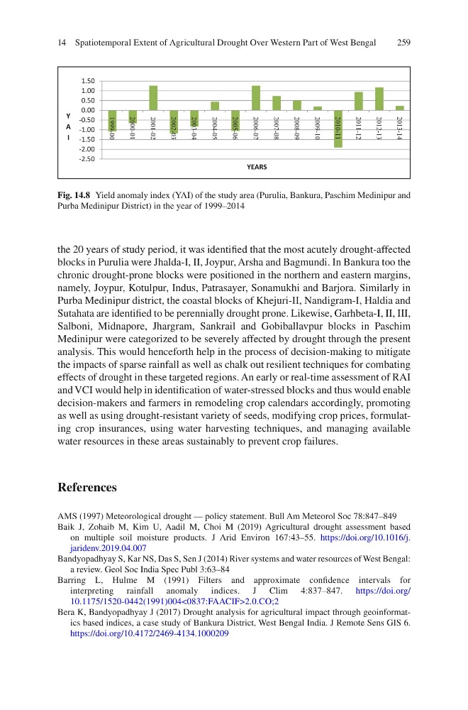
Fig. 14.8 Yield anomaly index (YAI) of the study area (Purulia, Bankura, Paschim Medinipur and
Purba Medinipur District) in the year of 1999–2014
14 Spatiotemporal Extent of Agricultural Drought Over Western Part of West Bengal
the 20 years of study period, it was identified that the most acutely drought-affected
blocks in Purulia were Jhalda-I, II, Joypur, Arsha and Bagmundi. In Bankura too the
chronic drought-prone blocks were positioned in the northern and eastern margins,
namely, Joypur, Kotulpur, Indus, Patrasayer, Sonamukhi and Barjora. Similarly in
Purba Medinipur district, the coastal blocks of Khejuri-II, Nandigram-I, Haldia and
Sutahata are identified to be perennially drought prone. Likewise, Garhbeta-I, II, III,
Salboni, Midnapore, Jhargram, Sankrail and Gobiballavpur blocks in Paschim
Medinipur were categorized to be severely affected by drought through the present
analysis. This would henceforth help in the process of decision-making to mitigate
the impacts of sparse rainfall as well as chalk out resilient techniques for combating
effects of drought in these targeted regions. An early or real-time assessment of RAI
and VCI would help in identification of water-stressed blocks and thus would enable
decision-makers and farmers in remodeling crop calendars accordingly, promoting
as well as using drought-resistant variety of seeds, modifying crop prices, formulating crop insurances, using water harvesting techniques, and managing available
water resources in these areas sustainably to prevent crop failures.
References
AMS (1997) Meteorological drought — policy statement. Bull Am Meteorol Soc 78:847–849
Baik J, Zohaib M, Kim U, Aadil M, Choi M (2019) Agricultural drought assessment based
on multiple soil moisture products. J Arid Environ 167:43–55. https://doi.org/10.1016/j.
jaridenv.2019.04.007
Bandyopadhyay S, Kar NS, Das S, Sen J (2014) River systems and water resources of West Bengal:
a review. Geol Soc India Spec Publ 3:63–84
Barring L, Hulme M (1991) Filters and approximate confidence intervals for
interpreting rainfall anomaly indices. J Clim 4:837–847. https://doi.org/
10.1175/1520-0442(1991)004<0837:FAACIF>2.0.CO;2
Bera K, Bandyopadhyay J (2017) Drought analysis for agricultural impact through geoinformatics based indices, a case study of Bankura District, West Bengal India. J Remote Sens GIS 6.
https://doi.org/10.4172/2469-4134.1000209
-2.50
-2.00
-1.50
-1.00
-0.50
0.00
0.50
1.00
1.50
1999-00
2000-01
2001-02
2002-03
2003-04
2004-05
2005-06
2006-07
2007-08
2008-09
2009-10
2010-11
2011-12
2012-13
2013-14
Y
A
I
YEARS
Fig. 14.8 Yield anomaly index (YAI) of the study area (Purulia, Bankura, Paschim Medinipur and
Purba Medinipur District) in the year of 1999–2014
14 Spatiotemporal Extent of Agricultural Drought Over Western Part of West Bengal