

transition or mixture of floristic elements. The tension zone
illustrated in Fig. 2.6 shows separation of the mixed forest
(M) and primarily broad-leaved forest (D) across the Great
Lakes states and provinces.
Coastal wetlands are important in the Great Lakes basin
in terms of biodiversity, nesting and migratory wildfowl
habitat, and maintenance of water levels and quality (Albert
2003). Wetlands comprise about 50% the Great Lakes
shoreline (Fig. 2.7). Some wetland types are include Lowland Mixed Coniferous and Broad-leaved Forest (A), Lowland Conifer Forest (B), and Non-forested Wetland
(C) (Fig. 2.8).
2.4
Relief and Elevation
The greatest elevations in the Great Lakes basin occur in the
Lake Superior and Lake Huron basins and are shown in the
darkest pattern of Fig. 2.9. The ranges in elevations give an
idea about the slopes present in the Great Lakes basin. Some
of the steepest relief occurs on the Bayfield and Keweenaw
Peninsulas and Nipigon area of Lake Superior, the eastern
and southern shores of Georgian Bay (Lake Huron), the
southern and eastern shores of Lake Erie, and the eastern
shore of Lake Ontario.
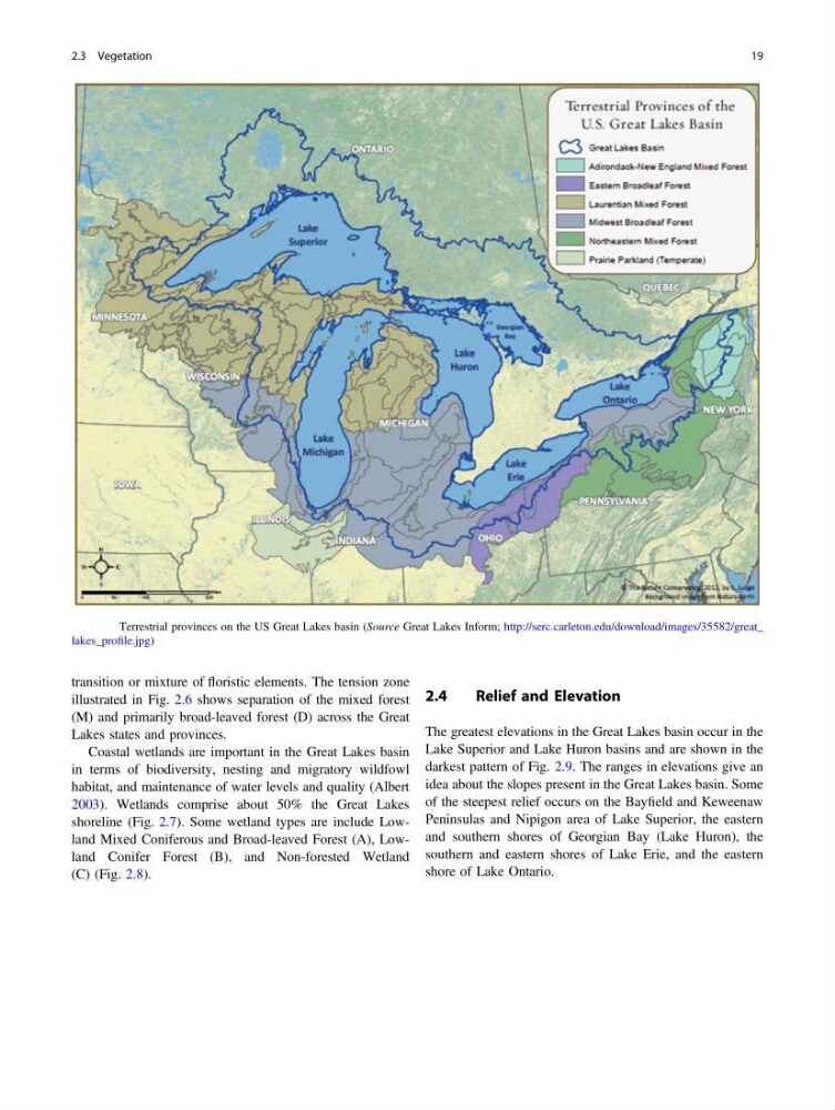
Fig. 2.3 Terrestrial provinces on the US Great Lakes basin (Source Great Lakes Inform; http://serc.carleton.edu/download/images/35582/great_
lakes_profile.jpg)
2.3 Vegetation
19
illustrated in Fig. 2.6 shows separation of the mixed forest
(M) and primarily broad-leaved forest (D) across the Great
Lakes states and provinces.
Coastal wetlands are important in the Great Lakes basin
in terms of biodiversity, nesting and migratory wildfowl
habitat, and maintenance of water levels and quality (Albert
2003). Wetlands comprise about 50% the Great Lakes
shoreline (Fig. 2.7). Some wetland types are include Lowland Mixed Coniferous and Broad-leaved Forest (A), Lowland Conifer Forest (B), and Non-forested Wetland
(C) (Fig. 2.8).
2.4
Relief and Elevation
The greatest elevations in the Great Lakes basin occur in the
Lake Superior and Lake Huron basins and are shown in the
darkest pattern of Fig. 2.9. The ranges in elevations give an
idea about the slopes present in the Great Lakes basin. Some
of the steepest relief occurs on the Bayfield and Keweenaw
Peninsulas and Nipigon area of Lake Superior, the eastern
and southern shores of Georgian Bay (Lake Huron), the
southern and eastern shores of Lake Erie, and the eastern
shore of Lake Ontario.
Fig. 2.3 Terrestrial provinces on the US Great Lakes basin (Source Great Lakes Inform; http://serc.carleton.edu/download/images/35582/great_
lakes_profile.jpg)
2.3 Vegetation
19