

a county on Lake Huron (Fig. 1.3). The map is composed of
17 map units and three soil series. The Clyde sand (gold
color) occurs on Nipissing-aged sediments (now Tobico
series); and the Clyde loam (gray) and Miami fine sandy
loam (pink) occur on what is now recognized as
wave-washed Port Huron till (Tappan-Belleville Association) from the Algonquin and Warren lake stages (Weesies
1980). The Web Soil Survey (2019) shows a similar distribution of soil series (not shown).
A soil map of Niagara County New York was published
by Pippen and Rice (1901) and represents the first map of a
county on Lake Ontario (Fig. 1.4). The map has 17 units and
four soil series. The Dunkirk soil series was divided into
eight soil types, with textures ranging from fine sand to clay.
The coastline features the Dunkirk sand (light brown) and
sandy loam (gold), a series that is still recognized along the
southern Lake Ontario shore (Web Soil Survey 2019). The
Collamer, Niagara, and Rhinebeck series were mapped on
the Iroquois lake terrace in the 1972 county survey and are
recognized on the shore today (not shown).
The earliest soil map on the Lake Erie shore was prepared
for Erie County PA in 1910 (Maynadier and Bucher 1912)
(Fig. 1.5). This map has 26 units and five soil series. The
Dunkirk soil series was divided into 11 soil types, with
textures ranging from gravel to clay. The Dunkirk gravelly
loam (yellow), sandy loam heavy phase (dark gray), and
sandy loam (pink) were mapped along the shore. The Presque Isle spit was mapped as dune sand. Although the
Dunkirk series is still mapped in Erie County, the dominant
soil series are the Rimer, Wauseon, and Berrien series (Web
Soil Survey 2019).
As of 2019, the entire US Great Lakes coastline has been
mapped at a scale of 1:24,000, except a small portion along
the northwestern shore of Lake Superior.
On the Canadian Great Lakes shoreline, the earliest soil
map was published in 1929 for Elgin County along the north
shore of Lake Erie. Soil mapping was begun in earnest
shortly after World War II, beginning in Durham (1946) and
Prince Edward (1948) counties on Lake Ontario and followed by Essex County on Lake Erie in 1949 (Table 1.4).
Soil survey coverage available in a digital GIS format is
shown in Fig. 1.6. The most recent published soil survey for
a county bordering a Great Lake in Canada was the revision
of Chatham-Kent Counties in 1996.
The number of soil series recognized in the US Great
Lakes Coastal Zone has increased linearly over the past
115 years (Fig. 1.7). Whereas only 15 soil series were
mapped in 1900, more than 650 have been mapped by 2010.
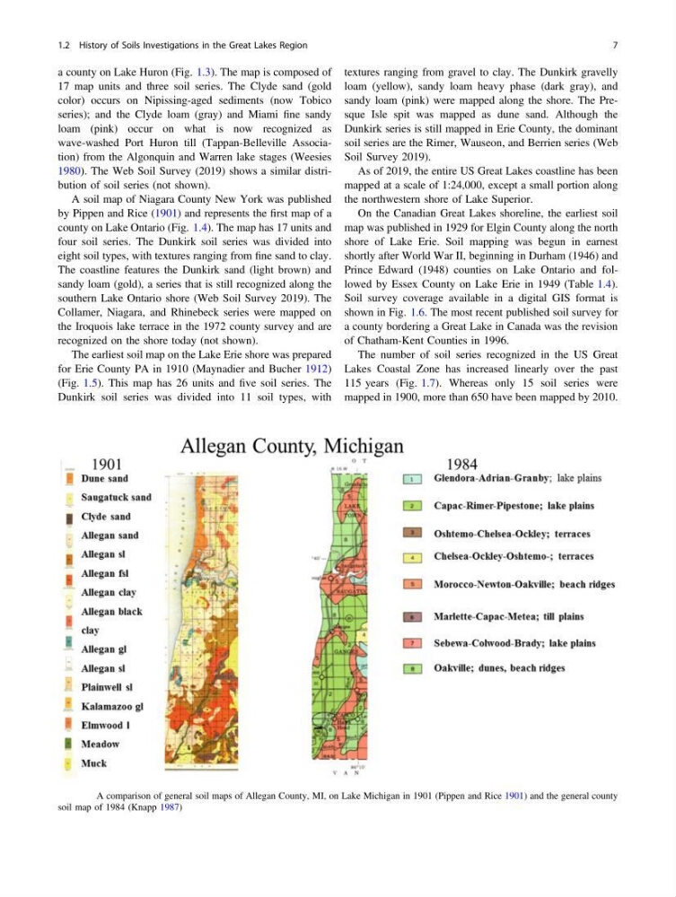
Fig. 1.1 A comparison of general soil maps of Allegan County, MI, on Lake Michigan in 1901 (Pippen and Rice 1901) and the general county
soil map of 1984 (Knapp 1987)
1.2 History of Soils Investigations in the Great Lakes Region
7
17 map units and three soil series. The Clyde sand (gold
color) occurs on Nipissing-aged sediments (now Tobico
series); and the Clyde loam (gray) and Miami fine sandy
loam (pink) occur on what is now recognized as
wave-washed Port Huron till (Tappan-Belleville Association) from the Algonquin and Warren lake stages (Weesies
1980). The Web Soil Survey (2019) shows a similar distribution of soil series (not shown).
A soil map of Niagara County New York was published
by Pippen and Rice (1901) and represents the first map of a
county on Lake Ontario (Fig. 1.4). The map has 17 units and
four soil series. The Dunkirk soil series was divided into
eight soil types, with textures ranging from fine sand to clay.
The coastline features the Dunkirk sand (light brown) and
sandy loam (gold), a series that is still recognized along the
southern Lake Ontario shore (Web Soil Survey 2019). The
Collamer, Niagara, and Rhinebeck series were mapped on
the Iroquois lake terrace in the 1972 county survey and are
recognized on the shore today (not shown).
The earliest soil map on the Lake Erie shore was prepared
for Erie County PA in 1910 (Maynadier and Bucher 1912)
(Fig. 1.5). This map has 26 units and five soil series. The
Dunkirk soil series was divided into 11 soil types, with
textures ranging from gravel to clay. The Dunkirk gravelly
loam (yellow), sandy loam heavy phase (dark gray), and
sandy loam (pink) were mapped along the shore. The Presque Isle spit was mapped as dune sand. Although the
Dunkirk series is still mapped in Erie County, the dominant
soil series are the Rimer, Wauseon, and Berrien series (Web
Soil Survey 2019).
As of 2019, the entire US Great Lakes coastline has been
mapped at a scale of 1:24,000, except a small portion along
the northwestern shore of Lake Superior.
On the Canadian Great Lakes shoreline, the earliest soil
map was published in 1929 for Elgin County along the north
shore of Lake Erie. Soil mapping was begun in earnest
shortly after World War II, beginning in Durham (1946) and
Prince Edward (1948) counties on Lake Ontario and followed by Essex County on Lake Erie in 1949 (Table 1.4).
Soil survey coverage available in a digital GIS format is
shown in Fig. 1.6. The most recent published soil survey for
a county bordering a Great Lake in Canada was the revision
of Chatham-Kent Counties in 1996.
The number of soil series recognized in the US Great
Lakes Coastal Zone has increased linearly over the past
115 years (Fig. 1.7). Whereas only 15 soil series were
mapped in 1900, more than 650 have been mapped by 2010.
Fig. 1.1 A comparison of general soil maps of Allegan County, MI, on Lake Michigan in 1901 (Pippen and Rice 1901) and the general county
soil map of 1984 (Knapp 1987)
1.2 History of Soils Investigations in the Great Lakes Region
7