

66
midlands, estuarine and coastal settlement sites that were known for their high food yields and provided food supply throughout the year according to the seasons.
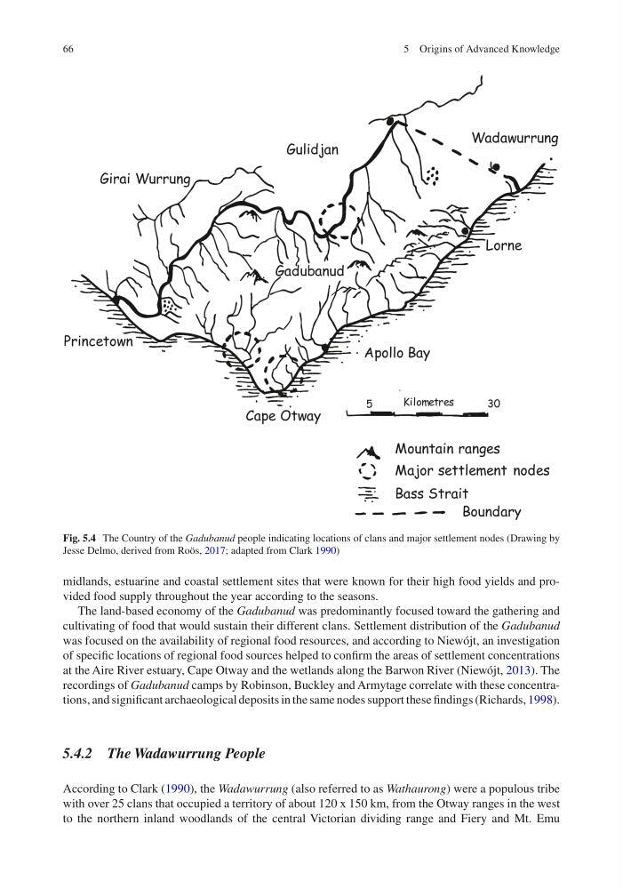
The land-based economy of the Gadubanud was predominantly focused toward the gathering and
cultivating of food that would sustain their different clans. Settlement distribution of the Gadubanud
was focused on the availability of regional food resources, and according to Niewójt, an investigation
of specific locations of regional food sources helped to confirm the areas of settlement concentrations
at the Aire River estuary, Cape Otway and the wetlands along the Barwon River (Niewójt, 2013). The
recordings of Gadubanud camps by Robinson, Buckley and Armytage correlate with these concentrations, and significant archaeological deposits in the same nodes support these findings (Richards, 1998).
5.4.2 The Wadawurrung People
According to Clark (1990), the Wadawurrung (also referred to as Wathaurong) were a populous tribe
with over 25 clans that occupied a territory of about 120 x 150 km, from the Otway ranges in the west
to the northern inland woodlands of the central Victorian dividing range and Fiery and Mt. Emu
Fig. 5.4 The Country of the Gadubanud people indicating locations of clans and major settlement nodes (Drawing by
Jesse Delmo, derived from Roös, 2017; adapted from Clark 1990)
5 Origins of Advanced Knowledge
midlands, estuarine and coastal settlement sites that were known for their high food yields and provided food supply throughout the year according to the seasons.
The land-based economy of the Gadubanud was predominantly focused toward the gathering and
cultivating of food that would sustain their different clans. Settlement distribution of the Gadubanud
was focused on the availability of regional food resources, and according to Niewójt, an investigation
of specific locations of regional food sources helped to confirm the areas of settlement concentrations
at the Aire River estuary, Cape Otway and the wetlands along the Barwon River (Niewójt, 2013). The
recordings of Gadubanud camps by Robinson, Buckley and Armytage correlate with these concentrations, and significant archaeological deposits in the same nodes support these findings (Richards, 1998).
5.4.2 The Wadawurrung People
According to Clark (1990), the Wadawurrung (also referred to as Wathaurong) were a populous tribe
with over 25 clans that occupied a territory of about 120 x 150 km, from the Otway ranges in the west
to the northern inland woodlands of the central Victorian dividing range and Fiery and Mt. Emu
Fig. 5.4 The Country of the Gadubanud people indicating locations of clans and major settlement nodes (Drawing by
Jesse Delmo, derived from Roös, 2017; adapted from Clark 1990)
5 Origins of Advanced Knowledge