

21
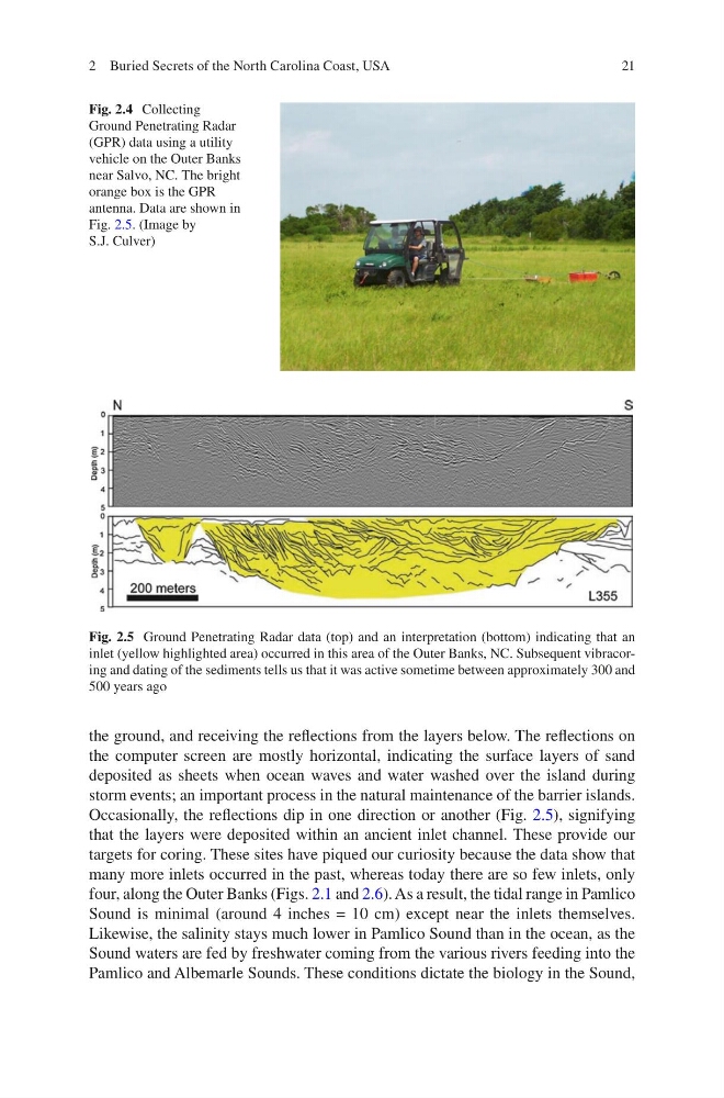
the ground, and receiving the reflections from the layers below. The reflections on
the computer screen are mostly horizontal, indicating the surface layers of sand
deposited as sheets when ocean waves and water washed over the island during
storm events; an important process in the natural maintenance of the barrier islands.
Occasionally, the reflections dip in one direction or another (Fig. 2.5), signifying
that the layers were deposited within an ancient inlet channel. These provide our
targets for coring. These sites have piqued our curiosity because the data show that
many more inlets occurred in the past, whereas today there are so few inlets, only
four, along the Outer Banks (Figs. 2.1 and 2.6). As a result, the tidal range in Pamlico
Sound is minimal (around 4 inches = 10 cm) except near the inlets themselves.
Likewise, the salinity stays much lower in Pamlico Sound than in the ocean, as the
Sound waters are fed by freshwater coming from the various rivers feeding into the
Pamlico and Albemarle Sounds. These conditions dictate the biology in the Sound,
Fig. 2.4 Collecting
Ground Penetrating Radar
(GPR) data using a utility
vehicle on the Outer Banks
near Salvo, NC. The bright
orange box is the GPR
antenna. Data are shown in
Fig. 2.5. (Image by
S.J. Culver)
Fig. 2.5 Ground Penetrating Radar data (top) and an interpretation (bottom) indicating that an
inlet (yellow highlighted area) occurred in this area of the Outer Banks, NC. Subsequent vibracoring and dating of the sediments tells us that it was active sometime between approximately 300 and
500 years ago
2 Buried Secrets of the North Carolina Coast, USA
the ground, and receiving the reflections from the layers below. The reflections on
the computer screen are mostly horizontal, indicating the surface layers of sand
deposited as sheets when ocean waves and water washed over the island during
storm events; an important process in the natural maintenance of the barrier islands.
Occasionally, the reflections dip in one direction or another (Fig. 2.5), signifying
that the layers were deposited within an ancient inlet channel. These provide our
targets for coring. These sites have piqued our curiosity because the data show that
many more inlets occurred in the past, whereas today there are so few inlets, only
four, along the Outer Banks (Figs. 2.1 and 2.6). As a result, the tidal range in Pamlico
Sound is minimal (around 4 inches = 10 cm) except near the inlets themselves.
Likewise, the salinity stays much lower in Pamlico Sound than in the ocean, as the
Sound waters are fed by freshwater coming from the various rivers feeding into the
Pamlico and Albemarle Sounds. These conditions dictate the biology in the Sound,
Fig. 2.4 Collecting
Ground Penetrating Radar
(GPR) data using a utility
vehicle on the Outer Banks
near Salvo, NC. The bright
orange box is the GPR
antenna. Data are shown in
Fig. 2.5. (Image by
S.J. Culver)
Fig. 2.5 Ground Penetrating Radar data (top) and an interpretation (bottom) indicating that an
inlet (yellow highlighted area) occurred in this area of the Outer Banks, NC. Subsequent vibracoring and dating of the sediments tells us that it was active sometime between approximately 300 and
500 years ago
2 Buried Secrets of the North Carolina Coast, USA