

220
whether by natural flooding events or the damming of the river. In the Rufiji Delta,
the Rufiji River changed course sometime in the mid-1970s to its current position
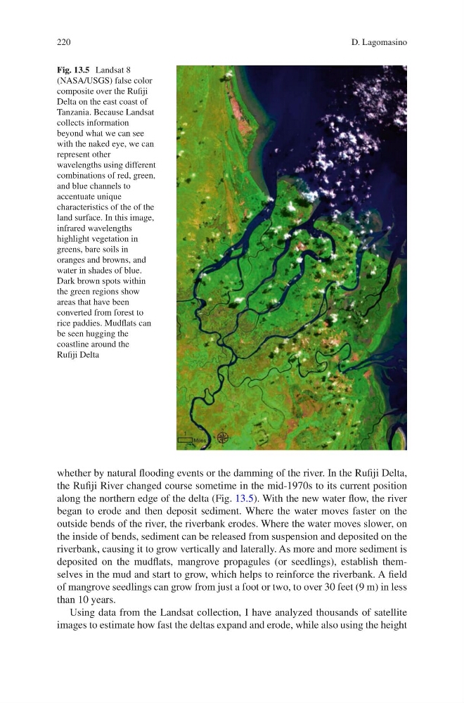
along the northern edge of the delta (Fig. 13.5). With the new water flow, the river
began to erode and then deposit sediment. Where the water moves faster on the
outside bends of the river, the riverbank erodes. Where the water moves slower, on
the inside of bends, sediment can be released from suspension and deposited on the
riverbank, causing it to grow vertically and laterally. As more and more sediment is
deposited on the mudflats, mangrove propagules (or seedlings), establish themselves in the mud and start to grow, which helps to reinforce the riverbank. A field
of mangrove seedlings can grow from just a foot or two, to over 30 feet (9 m) in less
than 10 years.
Using data from the Landsat collection, I have analyzed thousands of satellite
images to estimate how fast the deltas expand and erode, while also using the height
Fig. 13.5 Landsat 8
(NASA/USGS) false color
composite over the Rufiji
Delta on the east coast of
Tanzania. Because Landsat
collects information
beyond what we can see
with the naked eye, we can
represent other
wavelengths using different
combinations of red, green,
and blue channels to
accentuate unique
characteristics of the of the
land surface. In this image,
infrared wavelengths
highlight vegetation in
greens, bare soils in
oranges and browns, and
water in shades of blue.
Dark brown spots within
the green regions show
areas that have been
converted from forest to
rice paddies. Mudflats can
be seen hugging the
coastline around the
Rufiji Delta
D. Lagomasino
whether by natural flooding events or the damming of the river. In the Rufiji Delta,
the Rufiji River changed course sometime in the mid-1970s to its current position
along the northern edge of the delta (Fig. 13.5). With the new water flow, the river
began to erode and then deposit sediment. Where the water moves faster on the
outside bends of the river, the riverbank erodes. Where the water moves slower, on
the inside of bends, sediment can be released from suspension and deposited on the
riverbank, causing it to grow vertically and laterally. As more and more sediment is
deposited on the mudflats, mangrove propagules (or seedlings), establish themselves in the mud and start to grow, which helps to reinforce the riverbank. A field
of mangrove seedlings can grow from just a foot or two, to over 30 feet (9 m) in less
than 10 years.
Using data from the Landsat collection, I have analyzed thousands of satellite
images to estimate how fast the deltas expand and erode, while also using the height
Fig. 13.5 Landsat 8
(NASA/USGS) false color
composite over the Rufiji
Delta on the east coast of
Tanzania. Because Landsat
collects information
beyond what we can see
with the naked eye, we can
represent other
wavelengths using different
combinations of red, green,
and blue channels to
accentuate unique
characteristics of the of the
land surface. In this image,
infrared wavelengths
highlight vegetation in
greens, bare soils in
oranges and browns, and
water in shades of blue.
Dark brown spots within
the green regions show
areas that have been
converted from forest to
rice paddies. Mudflats can
be seen hugging the
coastline around the
Rufiji Delta
D. Lagomasino