

162
Even though this earthquake was a modern event, very little instrumentation was
in place locally to record it. Developing a set of tsunami characteristics for a known
event helps us better infer characteristics of pre-historic tsunami deposits where
there is no recorded information. Why is this important? It is quite dangerous to
base the hazard potential of an area on only one event. What if that event was small
in comparison to what has happened before or what if these events are much more
common than we think? The more we know about the possible range in magnitude
and frequency of tsunami, the better prepared society can be. We also gain insight
into the types of earthquakes that may have been associated with tsunami. Not all
tsunami are from nearby earthquakes and not all coastal earthquakes cause tsunami.
In general, earthquakes that don’t cause deformation of the seafloor don’t cause
tsunami, even if they are large events over M w 6. Further, tsunami can occur without
earthquakes – a submarine landslide down the slopes of Anak Krakatoa, an
Indonesian volcano, occurred in December, 2018, displacing water and causing a
tsunami that killed hundreds of people. One of the most important aspects to our
work on tsunami is to do it quite quickly after an event, before things are cleaned up,
removed, or altered by post-depositional processes (tides, storms, crab burrowing,
people etc.). So, in May of 2005, just five months after the devastating earthquake
and tsunami, and with some trepidation (I had not travelled to this part of the world
before), our team of four scientists and two students travelled to Malaysia to meet
our Malay colleagues and students and begin fieldwork.
In order to map the deposit of sediment laid down on land by the 2004 Indian
Ocean tsunami, we ran surface transects of elevation perpendicular to the coast
(Fig. 10.12), measured tsunami deposit depth and took samples for sediment grainsize and foraminiferal analyses. On one particular day, I was sent out ahead of the
group to place flags along the transect for students and colleagues to follow and take
elevation measurements and samples. Malaysia is an exotic locale for any modern
North American or European, and I distinctly remember asking if I should be aware
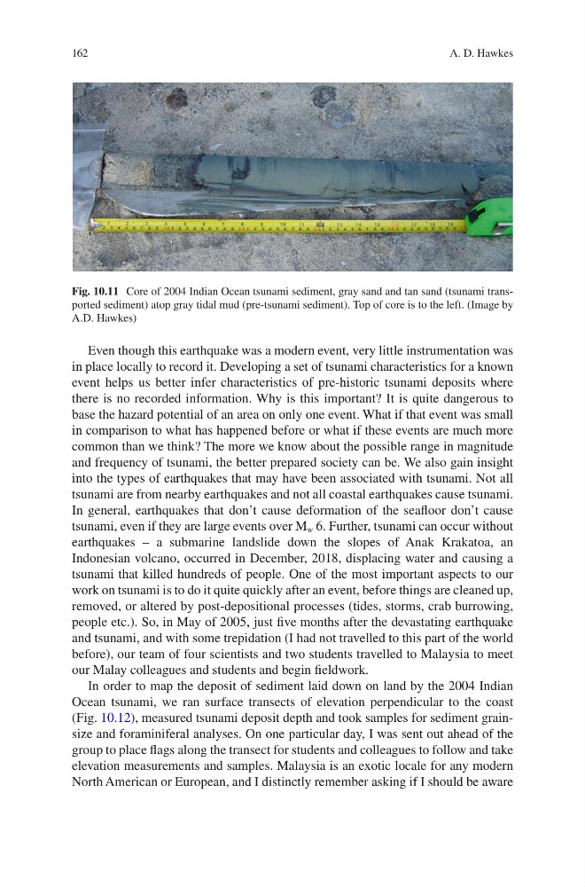
Fig. 10.11 Core of 2004 Indian Ocean tsunami sediment, gray sand and tan sand (tsunami transported sediment) atop gray tidal mud (pre-tsunami sediment). Top of core is to the left. (Image by
A.D. Hawkes)
A. D. Hawkes
Even though this earthquake was a modern event, very little instrumentation was
in place locally to record it. Developing a set of tsunami characteristics for a known
event helps us better infer characteristics of pre-historic tsunami deposits where
there is no recorded information. Why is this important? It is quite dangerous to
base the hazard potential of an area on only one event. What if that event was small
in comparison to what has happened before or what if these events are much more
common than we think? The more we know about the possible range in magnitude
and frequency of tsunami, the better prepared society can be. We also gain insight
into the types of earthquakes that may have been associated with tsunami. Not all
tsunami are from nearby earthquakes and not all coastal earthquakes cause tsunami.
In general, earthquakes that don’t cause deformation of the seafloor don’t cause
tsunami, even if they are large events over M w 6. Further, tsunami can occur without
earthquakes – a submarine landslide down the slopes of Anak Krakatoa, an
Indonesian volcano, occurred in December, 2018, displacing water and causing a
tsunami that killed hundreds of people. One of the most important aspects to our
work on tsunami is to do it quite quickly after an event, before things are cleaned up,
removed, or altered by post-depositional processes (tides, storms, crab burrowing,
people etc.). So, in May of 2005, just five months after the devastating earthquake
and tsunami, and with some trepidation (I had not travelled to this part of the world
before), our team of four scientists and two students travelled to Malaysia to meet
our Malay colleagues and students and begin fieldwork.
In order to map the deposit of sediment laid down on land by the 2004 Indian
Ocean tsunami, we ran surface transects of elevation perpendicular to the coast
(Fig. 10.12), measured tsunami deposit depth and took samples for sediment grainsize and foraminiferal analyses. On one particular day, I was sent out ahead of the
group to place flags along the transect for students and colleagues to follow and take
elevation measurements and samples. Malaysia is an exotic locale for any modern
North American or European, and I distinctly remember asking if I should be aware
Fig. 10.11 Core of 2004 Indian Ocean tsunami sediment, gray sand and tan sand (tsunami transported sediment) atop gray tidal mud (pre-tsunami sediment). Top of core is to the left. (Image by
A.D. Hawkes)
A. D. Hawkes