

160
Encounters with a ‘Komodo Dragon’, or Not?
Four months after starting my PhD, just two months after my advisor broke my
wrist in a soccer game (yes, this happened, I had to get a titanium plate, and yes, I
write it here to record the event in perpetuity) it was December of 2004 and the day
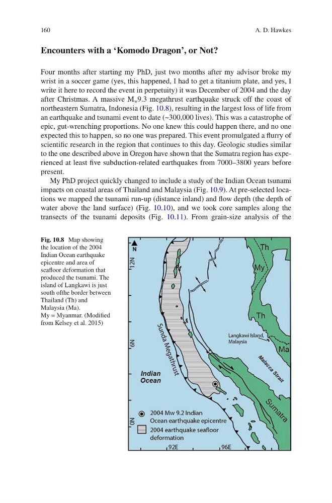
after Christmas. A massive M w 9.3 megathrust earthquake struck off the coast of
northeastern Sumatra, Indonesia (Fig. 10.8), resulting in the largest loss of life from
an earthquake and tsunami event to date (~300,000 lives). This was a catastrophe of
epic, gut-wrenching proportions. No one knew this could happen there, and no one
expected this to happen, so no one was prepared. This event promulgated a flurry of
scientific research in the region that continues to this day. Geologic studies similar
to the one described above in Oregon have shown that the Sumatra region has experienced at least five subduction-related earthquakes from 7000–3800 years before
present.
My PhD project quickly changed to include a study of the Indian Ocean tsunami
impacts on coastal areas of Thailand and Malaysia (Fig. 10.9). At pre-selected locations we mapped the tsunami run-up (distance inland) and flow depth (the depth of
water above the land surface) (Fig. 10.10), and we took core samples along the
transects of the tsunami deposits (Fig. 10.11). From grain-size analysis of the
Fig. 10.8 Map showing
the location of the 2004
Indian Ocean earthquake
epicentre and area of
seafloor deformation that
produced the tsunami. The
island of Langkawi is just
south ofthe border between
Thailand (Th) and
Malaysia (Ma).
My = Myanmar. (Modified
from Kelsey et al. 2015)
A. D. Hawkes
Encounters with a ‘Komodo Dragon’, or Not?
Four months after starting my PhD, just two months after my advisor broke my
wrist in a soccer game (yes, this happened, I had to get a titanium plate, and yes, I
write it here to record the event in perpetuity) it was December of 2004 and the day
after Christmas. A massive M w 9.3 megathrust earthquake struck off the coast of
northeastern Sumatra, Indonesia (Fig. 10.8), resulting in the largest loss of life from
an earthquake and tsunami event to date (~300,000 lives). This was a catastrophe of
epic, gut-wrenching proportions. No one knew this could happen there, and no one
expected this to happen, so no one was prepared. This event promulgated a flurry of
scientific research in the region that continues to this day. Geologic studies similar
to the one described above in Oregon have shown that the Sumatra region has experienced at least five subduction-related earthquakes from 7000–3800 years before
present.
My PhD project quickly changed to include a study of the Indian Ocean tsunami
impacts on coastal areas of Thailand and Malaysia (Fig. 10.9). At pre-selected locations we mapped the tsunami run-up (distance inland) and flow depth (the depth of
water above the land surface) (Fig. 10.10), and we took core samples along the
transects of the tsunami deposits (Fig. 10.11). From grain-size analysis of the
Fig. 10.8 Map showing
the location of the 2004
Indian Ocean earthquake
epicentre and area of
seafloor deformation that
produced the tsunami. The
island of Langkawi is just
south ofthe border between
Thailand (Th) and
Malaysia (Ma).
My = Myanmar. (Modified
from Kelsey et al. 2015)
A. D. Hawkes