

did not lead to adverse effects of salt accumulation or
redistribution. The earliest soil-related mapping in Otago
was undertaken by Hartley Ferrar in the 1920s.
Central Otago has the lowest national recorded mean
annual rainfall, 212 mm (in Alexandra in 1964), the lowest
national recorded air temperature of −25.6 °C (in Ranfurly in
1903), and some of the highest recorded temperatures in the
country. Central Otago is the region farthest from oceanic
influence, experiencing a near continental climate, explaining the temperature extremes. The surrounding mountain
ranges provide a rain shadow situation which explains the
low annual rainfall in the dry inland basins. Semiarid Soils
are dry for most of the growing season as, although the
highest rainfalls occur in the summer months, the moisture is
rapidly lost because of high rates of evapotranspiration at
that time of year. Rain is not sufficient in most years to leach
through the soil (Fig. 1.4), and so salts can accumulate in the
lower subsoil (Fig. 15.1). Thus, the soils have a high base
saturation (rich in ions of Na, K, Ca, and Mg) although the
cation exchange capacity may be limited because of the
coarse textures and low clay and organic matter content of
many Semiarid Soils. The lack of moisture limits plant
growth and hence drought-tolerant plants predominate
unless the land is irrigated.
Prominent ancient rocky outcrops of schist (tors) are an
important and unique feature of the Central Otago landscape.
The tors tower 10–20 m high above the surrounding surface
and were formed by a combination of physical weathering,
notably freeze-thaw cycles in periglacial conditions, during
glacials, and differential chemical weathering during
interglacials. Debris has been removed by wind and water
erosion as well as by solifluction (the slow, downslope
movement of water-saturated unconsolidated material,
instigated by freeze-thaw processes).
15.1.2 Areas of Occurrence
Semiarid Soils occur in the inland basins of Otago and
southern Canterbury, and in the upper Waitaki and Hakataramea valleys, where annual precipitation is less than about
500 mm (Fig. 15.2). They cover about 1% of New Zealand.
Although not yet tested by fieldwork, it has been suggested
by John Leathwick, from findings of the 'Land Environments
of New Zealand' project, that some of the inland basins of
Marlborough were climatically similar to those of Central
Otago basins and therefore Semiarid Soils may also be
present in them.
15.1.3 Variation Within the Semiarid Soil Order
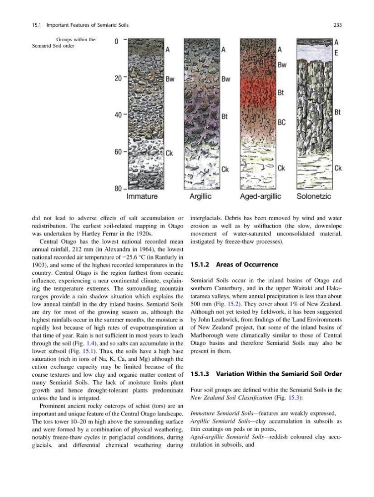
Four soil groups are defined within the Semiarid Soils in the
New Zealand Soil Classification (Fig. 15.3):
Immature Semiarid Soils—features are weakly expressed,
Argillic Semiarid Soils—clay accumulation in subsoils as
thin coatings on peds or in pores,
Aged-argillic Semiarid Soils—reddish coloured clay accumulation in subsoils, and
Fig. 15.3 Groups within the
Semiarid Soil order
15.1 Important Features of Semiarid Soils
233
redistribution. The earliest soil-related mapping in Otago
was undertaken by Hartley Ferrar in the 1920s.
Central Otago has the lowest national recorded mean
annual rainfall, 212 mm (in Alexandra in 1964), the lowest
national recorded air temperature of −25.6 °C (in Ranfurly in
1903), and some of the highest recorded temperatures in the
country. Central Otago is the region farthest from oceanic
influence, experiencing a near continental climate, explaining the temperature extremes. The surrounding mountain
ranges provide a rain shadow situation which explains the
low annual rainfall in the dry inland basins. Semiarid Soils
are dry for most of the growing season as, although the
highest rainfalls occur in the summer months, the moisture is
rapidly lost because of high rates of evapotranspiration at
that time of year. Rain is not sufficient in most years to leach
through the soil (Fig. 1.4), and so salts can accumulate in the
lower subsoil (Fig. 15.1). Thus, the soils have a high base
saturation (rich in ions of Na, K, Ca, and Mg) although the
cation exchange capacity may be limited because of the
coarse textures and low clay and organic matter content of
many Semiarid Soils. The lack of moisture limits plant
growth and hence drought-tolerant plants predominate
unless the land is irrigated.
Prominent ancient rocky outcrops of schist (tors) are an
important and unique feature of the Central Otago landscape.
The tors tower 10–20 m high above the surrounding surface
and were formed by a combination of physical weathering,
notably freeze-thaw cycles in periglacial conditions, during
glacials, and differential chemical weathering during
interglacials. Debris has been removed by wind and water
erosion as well as by solifluction (the slow, downslope
movement of water-saturated unconsolidated material,
instigated by freeze-thaw processes).
15.1.2 Areas of Occurrence
Semiarid Soils occur in the inland basins of Otago and
southern Canterbury, and in the upper Waitaki and Hakataramea valleys, where annual precipitation is less than about
500 mm (Fig. 15.2). They cover about 1% of New Zealand.
Although not yet tested by fieldwork, it has been suggested
by John Leathwick, from findings of the 'Land Environments
of New Zealand' project, that some of the inland basins of
Marlborough were climatically similar to those of Central
Otago basins and therefore Semiarid Soils may also be
present in them.
15.1.3 Variation Within the Semiarid Soil Order
Four soil groups are defined within the Semiarid Soils in the
New Zealand Soil Classification (Fig. 15.3):
Immature Semiarid Soils—features are weakly expressed,
Argillic Semiarid Soils—clay accumulation in subsoils as
thin coatings on peds or in pores,
Aged-argillic Semiarid Soils—reddish coloured clay accumulation in subsoils, and
Fig. 15.3 Groups within the
Semiarid Soil order
15.1 Important Features of Semiarid Soils
233