

Island and Bay of Plenty-Gisborne areas using field characteristics and stratigraphy.
In cases such as at Murupara, layers are usually readily
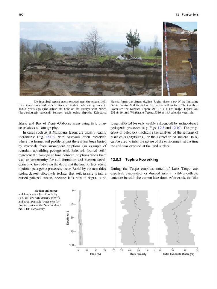
identifiable (Fig. 12.10), with paleosols often preserved
where the former soil profile or part thereof has been buried
by materials from subsequent eruptions (an example of
retardant upbuilding pedogenesis). Paleosols (buried soils)
represent the passage of time between eruptions when there
was an opportunity for soil formation and horizon development to take place on the deposit at the land surface where
topdown pedogenic processes occur. Burial by the next thick
tephra deposit effectively isolates that soil, turning it into a
buried paleosol which, because it is now at depth, is no
longer affected (or only weakly influenced) by surface-based
pedogenic processes (e.g. Figs. 12.8 and 12.10). The properties of paleosols (including the analysis of the remains of
plant cells (phytoliths), or the extraction of ancient DNA)
can be used to infer the nature of the environment at the time
the soil was exposed at the land surface.
12.3.3 Tephra Reworking
During the Taupo eruption, much of Lake Taupo was
expelled, evaporated, or drained into a caldera-collapse
structure beneath the current lake floor. Afterwards, the lake
Fig. 12.10 Distinct distal tephra layers exposed near Muraupara. Left:
river terrace covered with a stack of tephra beds dating back to
14,000 years ago (just below the floor of the quarry) with buried
(dark-coloured) paleosols between each tephra deposit. Kaingaroa
Plateau forms the distant skyline. Right: closer view of the Immature
Orthic Pumice Soil formed at the current soil surface. The top three
layers are the Kaharoa Tephra AD 1314 ± 12; Taupo Tephra AD
232 ± 10; and Whakatane Tephra 5526 ± 145 calendar years old
Fig. 12.11 Median and upper
and lower quartiles of soil clay
(%), soil dry bulk density (t m
−3
),
and total available water (%) for
Pumice Soils in the New Zealand
Soil Data Repository
190
12 Pumice Soils
In cases such as at Murupara, layers are usually readily
identifiable (Fig. 12.10), with paleosols often preserved
where the former soil profile or part thereof has been buried
by materials from subsequent eruptions (an example of
retardant upbuilding pedogenesis). Paleosols (buried soils)
represent the passage of time between eruptions when there
was an opportunity for soil formation and horizon development to take place on the deposit at the land surface where
topdown pedogenic processes occur. Burial by the next thick
tephra deposit effectively isolates that soil, turning it into a
buried paleosol which, because it is now at depth, is no
longer affected (or only weakly influenced) by surface-based
pedogenic processes (e.g. Figs. 12.8 and 12.10). The properties of paleosols (including the analysis of the remains of
plant cells (phytoliths), or the extraction of ancient DNA)
can be used to infer the nature of the environment at the time
the soil was exposed at the land surface.
12.3.3 Tephra Reworking
During the Taupo eruption, much of Lake Taupo was
expelled, evaporated, or drained into a caldera-collapse
structure beneath the current lake floor. Afterwards, the lake
Fig. 12.10 Distinct distal tephra layers exposed near Muraupara. Left:
river terrace covered with a stack of tephra beds dating back to
14,000 years ago (just below the floor of the quarry) with buried
(dark-coloured) paleosols between each tephra deposit. Kaingaroa
Plateau forms the distant skyline. Right: closer view of the Immature
Orthic Pumice Soil formed at the current soil surface. The top three
layers are the Kaharoa Tephra AD 1314 ± 12; Taupo Tephra AD
232 ± 10; and Whakatane Tephra 5526 ± 145 calendar years old
Fig. 12.11 Median and upper
and lower quartiles of soil clay
(%), soil dry bulk density (t m
−3
),
and total available water (%) for
Pumice Soils in the New Zealand
Soil Data Repository
190
12 Pumice Soils