

92
P. Lazo et al.
Table 8.1 (continued)
Var
F1
F2
F3
F4
F5
F6
Comm
Na
0.000
0.000
0.000
0.000
0.675
0.000
0.536
Se
0.000
0.000
0.000
0.000
0.000
0.849
0.778
I
0.000
0.000
0.000
0.000
0.000
0.730
0.664
Br
0.000
0.000
0.000
0.000
0.000
0.726
0.634
Var
9.403
6.613
4.296
3.461
3.168
2.688
29.628
% Var*
0.241
0.170
0.110
0.089
0.081
0.069
0.760
Var Variable; Var* Variance; Cumm Cummulative
Factor 3 (F3) is the next factor, explaining 11% of the total variance. It is characterised by high loadings of Sb, Zn, Hg, Pb, Cd, Cu and Ca (FL > 0.51). Sb, Zn, Hg, Pb,
Cd, Cu are typical elements of traffic emission, oil and gas industry, shipping activity
in the coastal areas, and the geogenic factors. These elements are also distinguished
as typical elements derived from anthropogenic sources that are mainly linked with
traffic emissions, geogenic origin, and wind-blown mineral dust particles of sulfide
mineral mine wastes (Lazo et al. 2018). The presence of Pb in this factor is probably derived from long-range transport (Harmens et al. 2015), traffic emission and
the emission from metallurgy, as another Pb potential origin (Harmens et al. 2010,
2015). Spatial analysis plot and GIS map of FL3 data is shown in Fig. 8.2.
Factor 4 (F4) represents 8.9% of the total variance. It is characterized by high
loading of Ni, Cr, Mg and Co (FL > 0.60). All these elements are typical elements
present in chromites and nickel ores, and are probably derived from mining industry,
ferro-chromium and ferro-nickel metallurgy of Elbasan (Lazo et al. 2013), from
geogenic origin and wind-blown mineral dust particles of mine wastes (Lazo et al.
2018). Spatial analysis plot and GIS map of FL4 data is shown in Fig. 8.3.
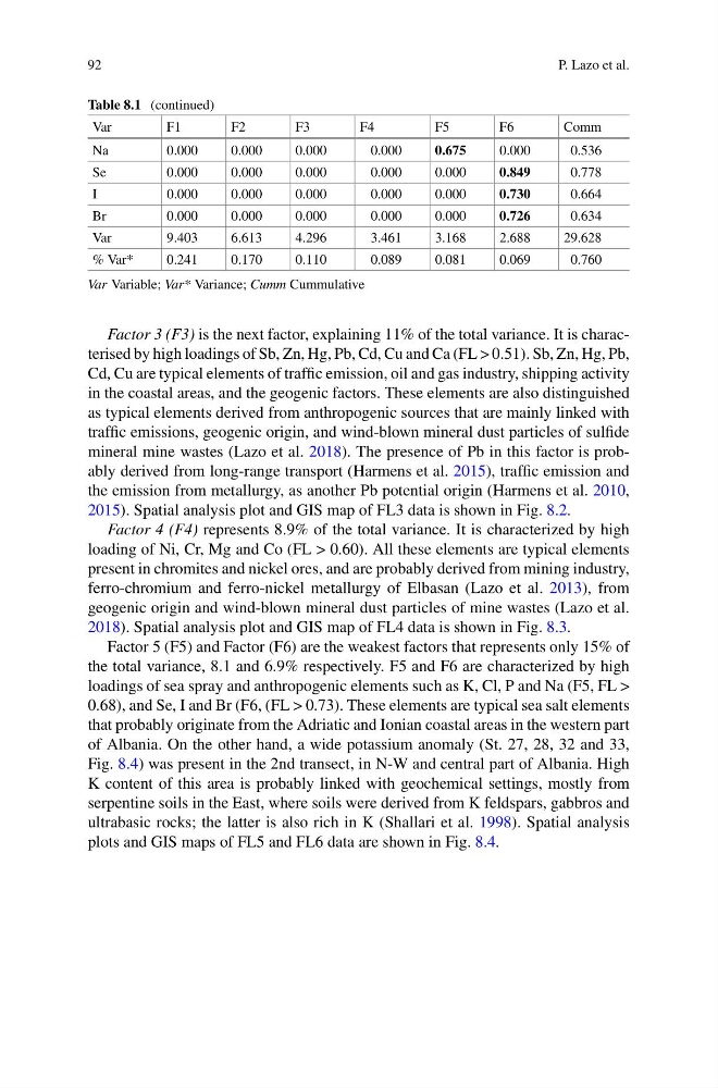
Factor 5 (F5) and Factor (F6) are the weakest factors that represents only 15% of
the total variance, 8.1 and 6.9% respectively. F5 and F6 are characterized by high
loadings of sea spray and anthropogenic elements such as K, Cl, P and Na (F5, FL >
0.68), and Se, I and Br (F6, (FL > 0.73). These elements are typical sea salt elements
that probably originate from the Adriatic and Ionian coastal areas in the western part
of Albania. On the other hand, a wide potassium anomaly (St. 27, 28, 32 and 33,
Fig. 8.4) was present in the 2nd transect, in N-W and central part of Albania. High
K content of this area is probably linked with geochemical settings, mostly from
serpentine soils in the East, where soils were derived from K feldspars, gabbros and
ultrabasic rocks; the latter is also rich in K (Shallari et al. 1998). Spatial analysis
plots and GIS maps of FL5 and FL6 data are shown in Fig. 8.4.
P. Lazo et al.
Table 8.1 (continued)
Var
F1
F2
F3
F4
F5
F6
Comm
Na
0.000
0.000
0.000
0.000
0.675
0.000
0.536
Se
0.000
0.000
0.000
0.000
0.000
0.849
0.778
I
0.000
0.000
0.000
0.000
0.000
0.730
0.664
Br
0.000
0.000
0.000
0.000
0.000
0.726
0.634
Var
9.403
6.613
4.296
3.461
3.168
2.688
29.628
% Var*
0.241
0.170
0.110
0.089
0.081
0.069
0.760
Var Variable; Var* Variance; Cumm Cummulative
Factor 3 (F3) is the next factor, explaining 11% of the total variance. It is characterised by high loadings of Sb, Zn, Hg, Pb, Cd, Cu and Ca (FL > 0.51). Sb, Zn, Hg, Pb,
Cd, Cu are typical elements of traffic emission, oil and gas industry, shipping activity
in the coastal areas, and the geogenic factors. These elements are also distinguished
as typical elements derived from anthropogenic sources that are mainly linked with
traffic emissions, geogenic origin, and wind-blown mineral dust particles of sulfide
mineral mine wastes (Lazo et al. 2018). The presence of Pb in this factor is probably derived from long-range transport (Harmens et al. 2015), traffic emission and
the emission from metallurgy, as another Pb potential origin (Harmens et al. 2010,
2015). Spatial analysis plot and GIS map of FL3 data is shown in Fig. 8.2.
Factor 4 (F4) represents 8.9% of the total variance. It is characterized by high
loading of Ni, Cr, Mg and Co (FL > 0.60). All these elements are typical elements
present in chromites and nickel ores, and are probably derived from mining industry,
ferro-chromium and ferro-nickel metallurgy of Elbasan (Lazo et al. 2013), from
geogenic origin and wind-blown mineral dust particles of mine wastes (Lazo et al.
2018). Spatial analysis plot and GIS map of FL4 data is shown in Fig. 8.3.
Factor 5 (F5) and Factor (F6) are the weakest factors that represents only 15% of
the total variance, 8.1 and 6.9% respectively. F5 and F6 are characterized by high
loadings of sea spray and anthropogenic elements such as K, Cl, P and Na (F5, FL >
0.68), and Se, I and Br (F6, (FL > 0.73). These elements are typical sea salt elements
that probably originate from the Adriatic and Ionian coastal areas in the western part
of Albania. On the other hand, a wide potassium anomaly (St. 27, 28, 32 and 33,
Fig. 8.4) was present in the 2nd transect, in N-W and central part of Albania. High
K content of this area is probably linked with geochemical settings, mostly from
serpentine soils in the East, where soils were derived from K feldspars, gabbros and
ultrabasic rocks; the latter is also rich in K (Shallari et al. 1998). Spatial analysis
plots and GIS maps of FL5 and FL6 data are shown in Fig. 8.4.