

medium sand and silt. The interlayer water mainly exists in the sand soil layer about
15–23 m deep. Water distribution in this layer is discontinuous across the whole
region, but mainly concentrated in the landfill site and its west. The thickness of the
aquifer is generally not greater than 3 m; The confined water mainly exists in the
sand and gravel layer about 25 m deep. The thickness of the aquifer is 5–18 m in
general and gradually increases towards the northern part of the landfill site, up to
more than 15 m.
2. Investigation of the informal landfill
The Chaoyang District informal landfill (hereinafter referred to as “the landfill”)
was originally a kiln pit and was later used for waste landfill. In 2010, a park was
built at the site of the original landfill. The landfill was used for burying domestic
refuse and mixed waste and had an area of about 237,000 m
2 .
(1) Distribution characteristics of leachate in the landfill
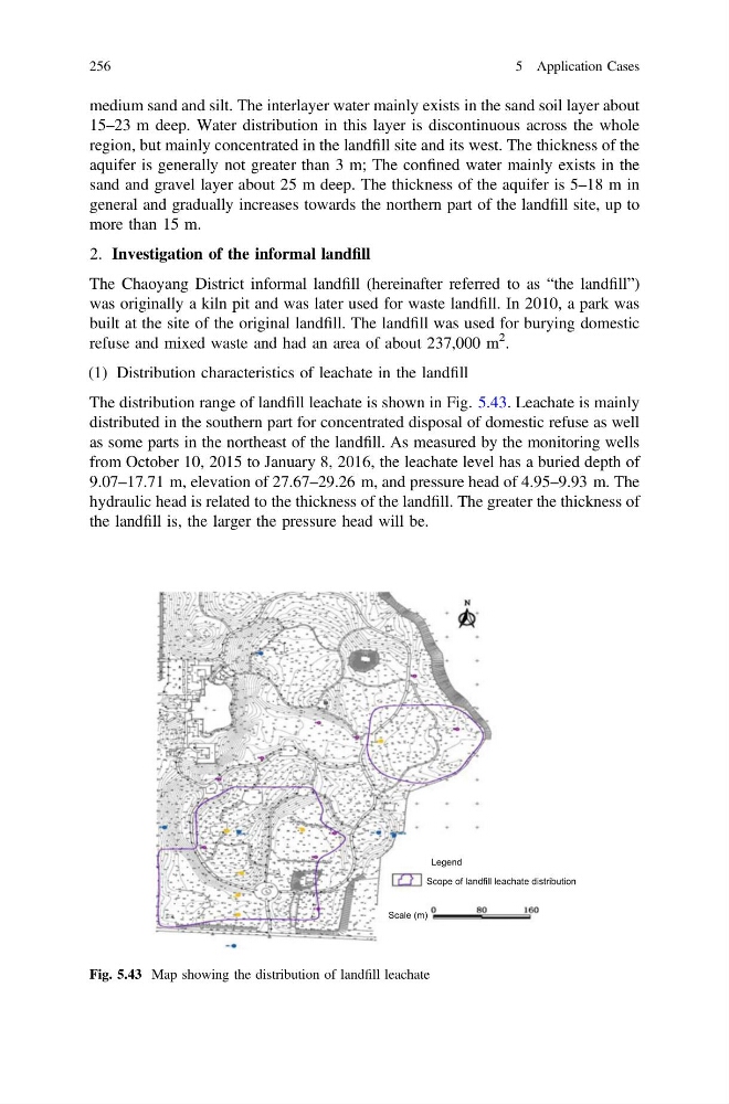
The distribution range of landfill leachate is shown in Fig. 5.43. Leachate is mainly
distributed in the southern part for concentrated disposal of domestic refuse as well
as some parts in the northeast of the landfill. As measured by the monitoring wells
from October 10, 2015 to January 8, 2016, the leachate level has a buried depth of
9.07–17.71 m, elevation of 27.67–29.26 m, and pressure head of 4.95–9.93 m. The
hydraulic head is related to the thickness of the landfill. The greater the thickness of
the landfill is, the larger the pressure head will be.
Legend
Scope of landfill leachate distribution
Scale (m)
Fig. 5.43 Map showing the distribution of landfill leachate
256
5 Application Cases
15–23 m deep. Water distribution in this layer is discontinuous across the whole
region, but mainly concentrated in the landfill site and its west. The thickness of the
aquifer is generally not greater than 3 m; The confined water mainly exists in the
sand and gravel layer about 25 m deep. The thickness of the aquifer is 5–18 m in
general and gradually increases towards the northern part of the landfill site, up to
more than 15 m.
2. Investigation of the informal landfill
The Chaoyang District informal landfill (hereinafter referred to as “the landfill”)
was originally a kiln pit and was later used for waste landfill. In 2010, a park was
built at the site of the original landfill. The landfill was used for burying domestic
refuse and mixed waste and had an area of about 237,000 m
2 .
(1) Distribution characteristics of leachate in the landfill
The distribution range of landfill leachate is shown in Fig. 5.43. Leachate is mainly
distributed in the southern part for concentrated disposal of domestic refuse as well
as some parts in the northeast of the landfill. As measured by the monitoring wells
from October 10, 2015 to January 8, 2016, the leachate level has a buried depth of
9.07–17.71 m, elevation of 27.67–29.26 m, and pressure head of 4.95–9.93 m. The
hydraulic head is related to the thickness of the landfill. The greater the thickness of
the landfill is, the larger the pressure head will be.
Legend
Scope of landfill leachate distribution
Scale (m)
Fig. 5.43 Map showing the distribution of landfill leachate
256
5 Application Cases