

The average annual precipitation of A city in a province in southeast China is
1740.2 mm, and the net groundwater recharge of the landfill is calculated according
to the formula.
(4) Aquifer
The aquifer in the landfill area is weathered eluvial pore-fissure phreatic water and
bedrock fissure phreatic water or feeble confined water, which mainly receives
vertical infiltration recharge from atmospheric precipitation, and the water environment alternates strongly and discharges to the nearby valleys. The basic flow
direction is from mountainous region to gullies: generally, in the wet season, the
groundwater is recharged by the surface water; in the dry season, the surface water
is recharged by the groundwater. The hydraulic connection between the two is
close. According to the classification of the vulnerable characteristics of aquifer in
the Technical Guidelines for Environmental Impact Assessment-Groundwater
Environment (HJ 610–2016), most groundwater aquifers of the landfill are
single-layer structure, and the hydraulic connection between groundwater and
surface water is close, so the groundwater aquifers are vulnerable to pollution.
(5) Vadose zone
The landfill is a low mountain landform with an average gradient of less than 15.
Gullies are developed in the area and the depression of gullies is deep and narrow. The
vertical permeability coefficient in the site is taken from the project closer to the
landfill area. Considering the maximum risk of the project construction, the maximum
value is taken, namely, the vertical permeability coefficient of the vadose zone is taken
as 4.00 Â 10
−5 m/s. According to the data of the six monitoring holes in the site by a
geological engineering survey institute in a province in Southeast China and the field
investigation, the thickness of the eluvial and diluvial soil layers is generally greater
than 1.0 m, and the distribution is continuous and stable. Therefore, according to the
classification table of antifouling property of vadose zone in the Technical Guidelines
for Environmental Impact Assessment-Groundwater Environment (HJ 610–2016),
the pollution-proof property of the vadose zone in the landfill is medium.
(6) Evaluation results
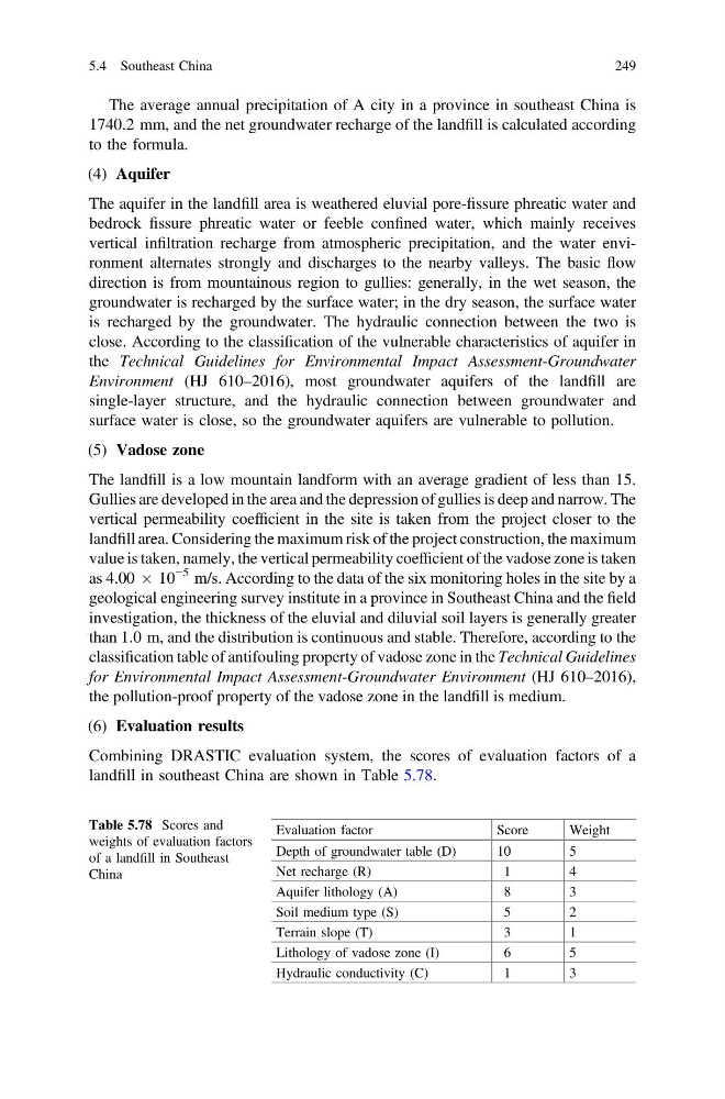
Combining DRASTIC evaluation system, the scores of evaluation factors of a
landfill in southeast China are shown in Table 5.78.
Table 5.78 Scores and
weights of evaluation factors
of a landfill in Southeast
China
Evaluation factor
Score
Weight
Depth of groundwater table (D)
10
5
Net recharge (R)
1
4
Aquifer lithology (A)
8
3
Soil medium type (S)
5
2
Terrain slope (T)
3
1
Lithology of vadose zone (I)
6
5
Hydraulic conductivity (C)
1
3
5.4 Southeast China
249
1740.2 mm, and the net groundwater recharge of the landfill is calculated according
to the formula.
(4) Aquifer
The aquifer in the landfill area is weathered eluvial pore-fissure phreatic water and
bedrock fissure phreatic water or feeble confined water, which mainly receives
vertical infiltration recharge from atmospheric precipitation, and the water environment alternates strongly and discharges to the nearby valleys. The basic flow
direction is from mountainous region to gullies: generally, in the wet season, the
groundwater is recharged by the surface water; in the dry season, the surface water
is recharged by the groundwater. The hydraulic connection between the two is
close. According to the classification of the vulnerable characteristics of aquifer in
the Technical Guidelines for Environmental Impact Assessment-Groundwater
Environment (HJ 610–2016), most groundwater aquifers of the landfill are
single-layer structure, and the hydraulic connection between groundwater and
surface water is close, so the groundwater aquifers are vulnerable to pollution.
(5) Vadose zone
The landfill is a low mountain landform with an average gradient of less than 15.
Gullies are developed in the area and the depression of gullies is deep and narrow. The
vertical permeability coefficient in the site is taken from the project closer to the
landfill area. Considering the maximum risk of the project construction, the maximum
value is taken, namely, the vertical permeability coefficient of the vadose zone is taken
as 4.00 Â 10
−5 m/s. According to the data of the six monitoring holes in the site by a
geological engineering survey institute in a province in Southeast China and the field
investigation, the thickness of the eluvial and diluvial soil layers is generally greater
than 1.0 m, and the distribution is continuous and stable. Therefore, according to the
classification table of antifouling property of vadose zone in the Technical Guidelines
for Environmental Impact Assessment-Groundwater Environment (HJ 610–2016),
the pollution-proof property of the vadose zone in the landfill is medium.
(6) Evaluation results
Combining DRASTIC evaluation system, the scores of evaluation factors of a
landfill in southeast China are shown in Table 5.78.
Table 5.78 Scores and
weights of evaluation factors
of a landfill in Southeast
China
Evaluation factor
Score
Weight
Depth of groundwater table (D)
10
5
Net recharge (R)
1
4
Aquifer lithology (A)
8
3
Soil medium type (S)
5
2
Terrain slope (T)
3
1
Lithology of vadose zone (I)
6
5
Hydraulic conductivity (C)
1
3
5.4 Southeast China
249