

II. Fissures
The structural fissures in the area are relatively developed, with the strike dominated
by NEE and NWW. Most NEE and NWW fissure surfaces are straight, without
filling, and the extension length is generally more than 5 m, with good connectivity.
In addition, according to geological prospecting data, most exploratory holes at the
site leak, revealing that the pores and fissures in the fully-strongly weathered zone
above the bedrock are relatively developed, and the fissures in the moderately
weathered tuff are relatively developed and permeable to water to a certain extent.
Once the seepage control network at the site is broken or other pollutants leak, these
fissures provide a good channel for leachate, and pollutants will be discharged along
the joints and fissures towards the downstream gully runoff.
The NWW structural fissures on both sides of the landfill area and the NEE
fissures on both sides of the leachate pool are particularly developed. The fissure
planes are straight, unfilled and slightly extensional. Several groups of fissures in
the rock mass on the north slope of the leachate pool are colored with iron, indicating that the fissures are well connected and have certain permeability. Once
leachate leaks, the fissures will directly become a transmission channel. Therefore,
it is necessary to take measures to prevent pollution and seepage and prevent
pollutants from directly entering the underground aquifers through surface runoff
due to seepage control accidents and improper discharge.
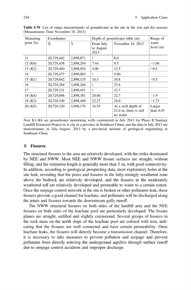
Table 5.70 List of range measurements of groundwater at the site in the wet and dry seasons
(Measurement Time November 18, 2013)
Measuring
point No.
Coordinates
Depth of groundwater table (m)
Range of
water
level (m)
X
Y
From July
to August
2013
November 18, 2013
11
20,729,442
2,898,071
\
6.0
12 (K6)
20,729,438
2,898,204
7.44
8.5
−1.06
13 (K2)
20,729,460
2,898,054
4.00
12.5
−8.5
14
20,729,477
2,898,083
\
9.00
15 (K1)
20,729,642
2,898,135
10.3
10.8
−0.5
16
20,729,284
2,898,266
\
23.8
17
20,729,131
2,898,451
\
12.7
18 (K4)
20,729,046
2,898,381
20.80
22.7
−1.9
19 (K3)
20,729,349
2,898,409
22.27
24.0
−1.73
20 (K5)
20,729,120
2,898,176
16.55
At a well depth of
21.0 m, there is still
no water.
Larger
than 4.45
Note K1–K6 are groundwater monitoring wells constructed in July 2013 for Phase II Sanitary
Landfill Extension Project in A city in a province in Southeast China, and the data in July 2013 are
measurements in July–August, 2013 by a provincial institute of geological engineering in
Southeast China
234
5 Application Cases
The structural fissures in the area are relatively developed, with the strike dominated
by NEE and NWW. Most NEE and NWW fissure surfaces are straight, without
filling, and the extension length is generally more than 5 m, with good connectivity.
In addition, according to geological prospecting data, most exploratory holes at the
site leak, revealing that the pores and fissures in the fully-strongly weathered zone
above the bedrock are relatively developed, and the fissures in the moderately
weathered tuff are relatively developed and permeable to water to a certain extent.
Once the seepage control network at the site is broken or other pollutants leak, these
fissures provide a good channel for leachate, and pollutants will be discharged along
the joints and fissures towards the downstream gully runoff.
The NWW structural fissures on both sides of the landfill area and the NEE
fissures on both sides of the leachate pool are particularly developed. The fissure
planes are straight, unfilled and slightly extensional. Several groups of fissures in
the rock mass on the north slope of the leachate pool are colored with iron, indicating that the fissures are well connected and have certain permeability. Once
leachate leaks, the fissures will directly become a transmission channel. Therefore,
it is necessary to take measures to prevent pollution and seepage and prevent
pollutants from directly entering the underground aquifers through surface runoff
due to seepage control accidents and improper discharge.
Table 5.70 List of range measurements of groundwater at the site in the wet and dry seasons
(Measurement Time November 18, 2013)
Measuring
point No.
Coordinates
Depth of groundwater table (m)
Range of
water
level (m)
X
Y
From July
to August
2013
November 18, 2013
11
20,729,442
2,898,071
\
6.0
12 (K6)
20,729,438
2,898,204
7.44
8.5
−1.06
13 (K2)
20,729,460
2,898,054
4.00
12.5
−8.5
14
20,729,477
2,898,083
\
9.00
15 (K1)
20,729,642
2,898,135
10.3
10.8
−0.5
16
20,729,284
2,898,266
\
23.8
17
20,729,131
2,898,451
\
12.7
18 (K4)
20,729,046
2,898,381
20.80
22.7
−1.9
19 (K3)
20,729,349
2,898,409
22.27
24.0
−1.73
20 (K5)
20,729,120
2,898,176
16.55
At a well depth of
21.0 m, there is still
no water.
Larger
than 4.45
Note K1–K6 are groundwater monitoring wells constructed in July 2013 for Phase II Sanitary
Landfill Extension Project in A city in a province in Southeast China, and the data in July 2013 are
measurements in July–August, 2013 by a provincial institute of geological engineering in
Southeast China
234
5 Application Cases