

Study Area
India is the tropical monsoon country of Southeast Asia, particularly well known for
agricultural production. The whole study area lies between latitudes 8
04
0 N and
37
06
0 N and longitude 68
07
0 E and 97
25
0 E, with an area of 3,434,833 km
2 . The
country is characterized by four seasons: pre-monsoon (March to May) with high
temperature and high evaporation, monsoon (June to September) with high intensity
of rainfall, post-monsoon (October to November), the hot and humid period with less
rainfall, and finally the winter season (December to February), the coldest and driest
period. India can be separated into five physiographic divisions: (i) the Himalayan
Mountain, (ii) the Great Plain of North India, (iii) the Peninsular Plateau, (iv) the
Coastal Plains, and (v) the Islands. The Himalaya and the Thar Desert strongly affect
the weather of the country, making it vulnerable to climate, economic, and cultural
change. The largest share of the semiarid rainfed agriculture system and nearly
700 million of her 1 billion population living in rural areas directly depend on
climate-sensitive sectors. This large section of the population is likely to be most
affected by climate change because their livelihoods are critically correlated with
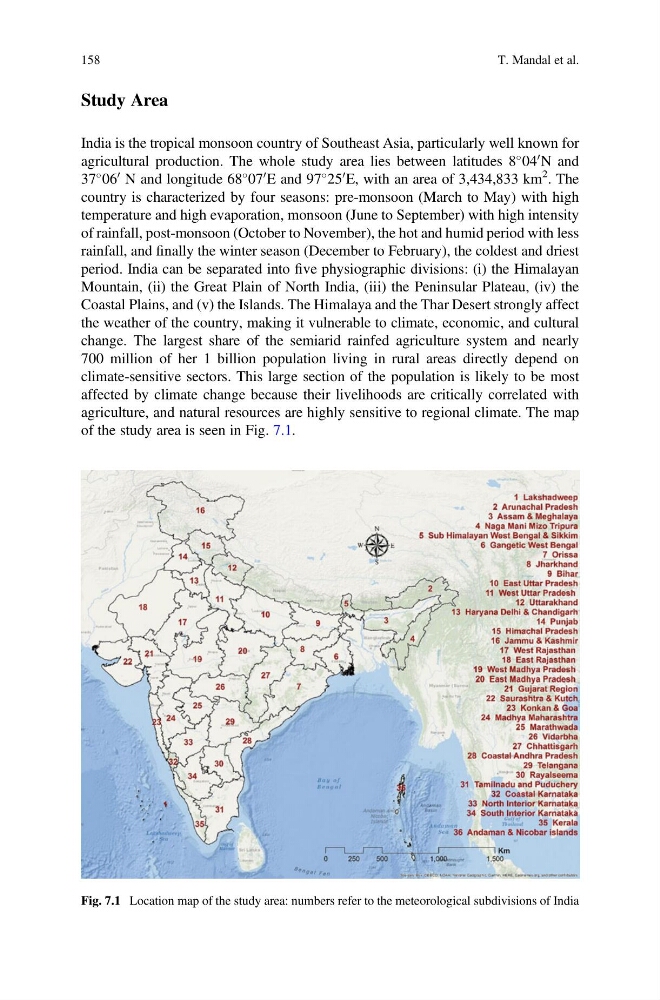
agriculture, and natural resources are highly sensitive to regional climate. The map
of the study area is seen in Fig. 7.1.
Fig. 7.1 Location map of the study area: numbers refer to the meteorological subdivisions of India
158
T. Mandal et al.
India is the tropical monsoon country of Southeast Asia, particularly well known for
agricultural production. The whole study area lies between latitudes 8
04
0 N and
37
06
0 N and longitude 68
07
0 E and 97
25
0 E, with an area of 3,434,833 km
2 . The
country is characterized by four seasons: pre-monsoon (March to May) with high
temperature and high evaporation, monsoon (June to September) with high intensity
of rainfall, post-monsoon (October to November), the hot and humid period with less
rainfall, and finally the winter season (December to February), the coldest and driest
period. India can be separated into five physiographic divisions: (i) the Himalayan
Mountain, (ii) the Great Plain of North India, (iii) the Peninsular Plateau, (iv) the
Coastal Plains, and (v) the Islands. The Himalaya and the Thar Desert strongly affect
the weather of the country, making it vulnerable to climate, economic, and cultural
change. The largest share of the semiarid rainfed agriculture system and nearly
700 million of her 1 billion population living in rural areas directly depend on
climate-sensitive sectors. This large section of the population is likely to be most
affected by climate change because their livelihoods are critically correlated with
agriculture, and natural resources are highly sensitive to regional climate. The map
of the study area is seen in Fig. 7.1.
Fig. 7.1 Location map of the study area: numbers refer to the meteorological subdivisions of India
158
T. Mandal et al.