

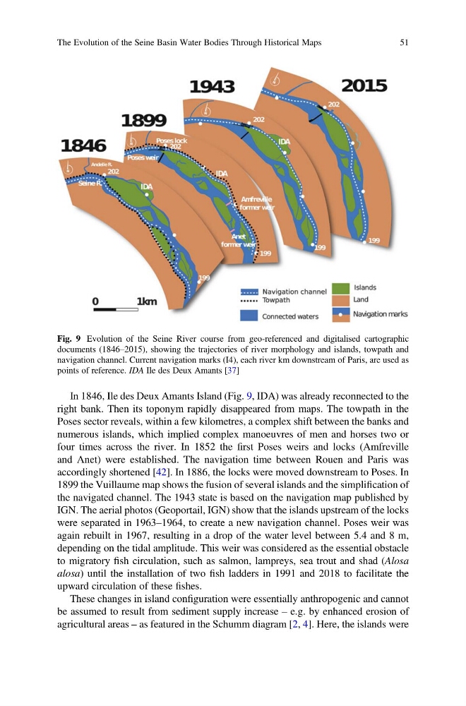
In 1846, Ile des Deux Amants Island (Fig. 9, IDA) was already reconnected to the
right bank. Then its toponym rapidly disappeared from maps. The towpath in the
Poses sector reveals, within a few kilometres, a complex shift between the banks and
numerous islands, which implied complex manoeuvres of men and horses two or
four times across the river. In 1852 the first Poses weirs and locks (Amfreville
and Anet) were established. The navigation time between Rouen and Paris was
accordingly shortened [42]. In 1886, the locks were moved downstream to Poses. In
1899 the Vuillaume map shows the fusion of several islands and the simplification of
the navigated channel. The 1943 state is based on the navigation map published by
IGN. The aerial photos (Geoportail, IGN) show that the islands upstream of the locks
were separated in 1963–1964, to create a new navigation channel. Poses weir was
again rebuilt in 1967, resulting in a drop of the water level between 5.4 and 8 m,
depending on the tidal amplitude. This weir was considered as the essential obstacle
to migratory fish circulation, such as salmon, lampreys, sea trout and shad (Alosa
alosa) until the installation of two fish ladders in 1991 and 2018 to facilitate the
upward circulation of these fishes.
These changes in island configuration were essentially anthropogenic and cannot
be assumed to result from sediment supply increase – e.g. by enhanced erosion of
agricultural areas – as featured in the Schumm diagram [2, 4]. Here, the islands were
Fig. 9 Evolution of the Seine River course from geo-referenced and digitalised cartographic
documents (1846–2015), showing the trajectories of river morphology and islands, towpath and
navigation channel. Current navigation marks (I4), each river km downstream of Paris, are used as
points of reference. IDA Ile des Deux Amants [37]
The Evolution of the Seine Basin Water Bodies Through Historical Maps
51
right bank. Then its toponym rapidly disappeared from maps. The towpath in the
Poses sector reveals, within a few kilometres, a complex shift between the banks and
numerous islands, which implied complex manoeuvres of men and horses two or
four times across the river. In 1852 the first Poses weirs and locks (Amfreville
and Anet) were established. The navigation time between Rouen and Paris was
accordingly shortened [42]. In 1886, the locks were moved downstream to Poses. In
1899 the Vuillaume map shows the fusion of several islands and the simplification of
the navigated channel. The 1943 state is based on the navigation map published by
IGN. The aerial photos (Geoportail, IGN) show that the islands upstream of the locks
were separated in 1963–1964, to create a new navigation channel. Poses weir was
again rebuilt in 1967, resulting in a drop of the water level between 5.4 and 8 m,
depending on the tidal amplitude. This weir was considered as the essential obstacle
to migratory fish circulation, such as salmon, lampreys, sea trout and shad (Alosa
alosa) until the installation of two fish ladders in 1991 and 2018 to facilitate the
upward circulation of these fishes.
These changes in island configuration were essentially anthropogenic and cannot
be assumed to result from sediment supply increase – e.g. by enhanced erosion of
agricultural areas – as featured in the Schumm diagram [2, 4]. Here, the islands were
Fig. 9 Evolution of the Seine River course from geo-referenced and digitalised cartographic
documents (1846–2015), showing the trajectories of river morphology and islands, towpath and
navigation channel. Current navigation marks (I4), each river km downstream of Paris, are used as
points of reference. IDA Ile des Deux Amants [37]
The Evolution of the Seine Basin Water Bodies Through Historical Maps
51