

2.3 The Land Cover
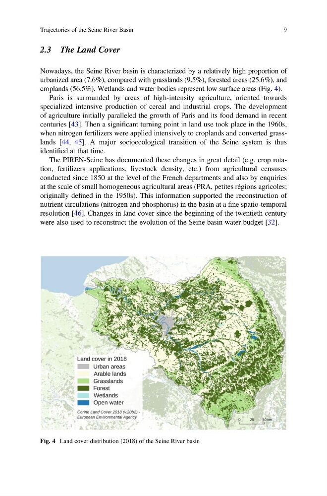
Nowadays, the Seine River basin is characterized by a relatively high proportion of
urbanized area (7.6%), compared with grasslands (9.5%), forested areas (25.6%), and
croplands (56.5%). Wetlands and water bodies represent low surface areas (Fig. 4).
Paris is surrounded by areas of high-intensity agriculture, oriented towards
specialized intensive production of cereal and industrial crops. The development
of agriculture initially paralleled the growth of Paris and its food demand in recent
centuries [43]. Then a significant turning point in land use took place in the 1960s,
when nitrogen fertilizers were applied intensively to croplands and converted grasslands [44, 45]. A major socioecological transition of the Seine system is thus
identified at that time.
The PIREN-Seine has documented these changes in great detail (e.g. crop rotation, fertilizers applications, livestock density, etc.) from agricultural censuses
conducted since 1850 at the level of the French departments and also by enquiries
at the scale of small homogeneous agricultural areas (PRA, petites régions agricoles;
originally defined in the 1950s). This information supported the reconstruction of
nutrient circulations (nitrogen and phosphorus) in the basin at a fine spatio-temporal
resolution [46]. Changes in land cover since the beginning of the twentieth century
were also used to reconstruct the evolution of the Seine basin water budget [32].
Fig. 4 Land cover distribution (2018) of the Seine River basin
Trajectories of the Seine River Basin
9
Nowadays, the Seine River basin is characterized by a relatively high proportion of
urbanized area (7.6%), compared with grasslands (9.5%), forested areas (25.6%), and
croplands (56.5%). Wetlands and water bodies represent low surface areas (Fig. 4).
Paris is surrounded by areas of high-intensity agriculture, oriented towards
specialized intensive production of cereal and industrial crops. The development
of agriculture initially paralleled the growth of Paris and its food demand in recent
centuries [43]. Then a significant turning point in land use took place in the 1960s,
when nitrogen fertilizers were applied intensively to croplands and converted grasslands [44, 45]. A major socioecological transition of the Seine system is thus
identified at that time.
The PIREN-Seine has documented these changes in great detail (e.g. crop rotation, fertilizers applications, livestock density, etc.) from agricultural censuses
conducted since 1850 at the level of the French departments and also by enquiries
at the scale of small homogeneous agricultural areas (PRA, petites régions agricoles;
originally defined in the 1950s). This information supported the reconstruction of
nutrient circulations (nitrogen and phosphorus) in the basin at a fine spatio-temporal
resolution [46]. Changes in land cover since the beginning of the twentieth century
were also used to reconstruct the evolution of the Seine basin water budget [32].
Fig. 4 Land cover distribution (2018) of the Seine River basin
Trajectories of the Seine River Basin
9