

tertiary, Fig. 2a). The lithology of the basin encompasses carbonates (69.6%) and
sandy formations (13.6%), interbedded by poorly permeable clayey and marl units
(9.1%) and covered by alluvial deposits (5.4%) (Fig. 2b) [27]. The sedimentary basin
is covered by carbonated loess in its western and central parts [28].
The river network can be described using the Strahler stream order concept [29],
which is used throughout the morphological, hydrological, and biogeochemical
modelling of the Seine basin. The total length of the river network is 27,500 km,
mostly composed of first and second Strahler orders. The main tributaries of the
Seine River are the Yonne River, the Marne River, and the Oise River. The Seine
River reaches the seventh Strahler order after its confluence with the Yonne River.
The hydrological regime of the Seine River basin is pluvial/oceanic. The mean
rainfall over the basin is 800 mm year
À1 and exhibits some spatial variability, with a
maximum of around 1,200 mm year
À1 along the coastal shoreline and in the Morvan
mountainous range and only 650 mm year
À1 in its central part [30–32]. For the past
50 years, the Seine discharge at the last gauging station before the estuary at Poses
has had an average value of 485 m
3 s
À1 but reached 2,280 m
3 s
À1 in winter, with
summer minimums at 80 m
3 s
À1 (low flows sustained by reservoirs). In addition to
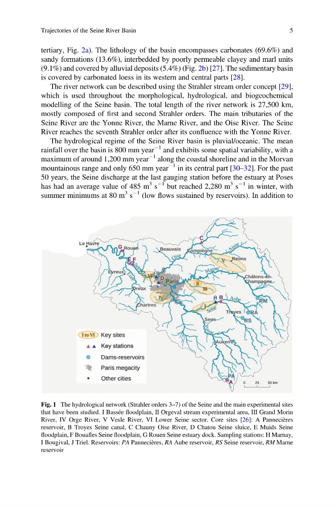
Fig. 1 The hydrological network (Strahler orders 3–7) of the Seine and the main experimental sites
that have been studied. I Bassée floodplain, II Orgeval stream experimental area, III Grand Morin
River, IV Orge River, V Vesle River, VI Lower Seine sector. Core sites [26]: A Pannecières
reservoir, B Troyes Seine canal, C Chauny Oise River, D Chatou Seine sluice, E Muids Seine
floodplain, F Bouafles Seine floodplain, G Rouen Seine estuary dock. Sampling stations: H Marnay,
I Bougival, J Triel. Reservoirs: PA Pannecières, RA Aube reservoir, RS Seine reservoir, RM Marne
reservoir
Trajectories of the Seine River Basin
5
sandy formations (13.6%), interbedded by poorly permeable clayey and marl units
(9.1%) and covered by alluvial deposits (5.4%) (Fig. 2b) [27]. The sedimentary basin
is covered by carbonated loess in its western and central parts [28].
The river network can be described using the Strahler stream order concept [29],
which is used throughout the morphological, hydrological, and biogeochemical
modelling of the Seine basin. The total length of the river network is 27,500 km,
mostly composed of first and second Strahler orders. The main tributaries of the
Seine River are the Yonne River, the Marne River, and the Oise River. The Seine
River reaches the seventh Strahler order after its confluence with the Yonne River.
The hydrological regime of the Seine River basin is pluvial/oceanic. The mean
rainfall over the basin is 800 mm year
À1 and exhibits some spatial variability, with a
maximum of around 1,200 mm year
À1 along the coastal shoreline and in the Morvan
mountainous range and only 650 mm year
À1 in its central part [30–32]. For the past
50 years, the Seine discharge at the last gauging station before the estuary at Poses
has had an average value of 485 m
3 s
À1 but reached 2,280 m
3 s
À1 in winter, with
summer minimums at 80 m
3 s
À1 (low flows sustained by reservoirs). In addition to
Fig. 1 The hydrological network (Strahler orders 3–7) of the Seine and the main experimental sites
that have been studied. I Bassée floodplain, II Orgeval stream experimental area, III Grand Morin
River, IV Orge River, V Vesle River, VI Lower Seine sector. Core sites [26]: A Pannecières
reservoir, B Troyes Seine canal, C Chauny Oise River, D Chatou Seine sluice, E Muids Seine
floodplain, F Bouafles Seine floodplain, G Rouen Seine estuary dock. Sampling stations: H Marnay,
I Bougival, J Triel. Reservoirs: PA Pannecières, RA Aube reservoir, RS Seine reservoir, RM Marne
reservoir
Trajectories of the Seine River Basin
5