

including industrial and domestic wastewater (about ten million inhabitants), runoff,
parasite water, groundwater infiltration and street cleaning water. Depending on
the location, the Paris conurbation was drained by combined sewers (30% of the
surface area), separate sewers (56%) or a combination of separate and combined sewers
(14%). However, due to the high population density in the historical centre, the daily
volume of wastewater mainly originated from combined sewers (75%). In 2014, over
112,000 tons dry weight of sludge was produced during wastewater treatment. It was
used for energy purposes (41%), spread over agricultural lands (29%), composted
further before spreading (22%) or stored as hazardous material (8%) [15]. Across the
conurbation, an average of 24% of the surface was impervious, while the remaining
had a limited infiltration capacity leading to a mean runoff coefficient of 0.7 [16]. In
2014, the annual rainfall over the Paris conurbation was 713 mm.
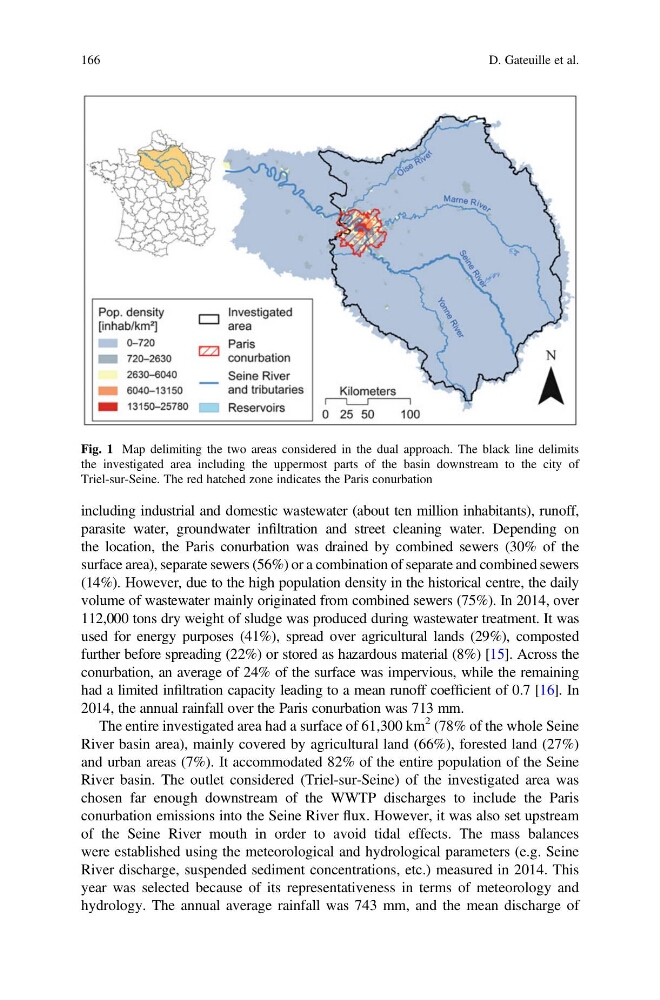
The entire investigated area had a surface of 61,300 km
2 (78% of the whole Seine
River basin area), mainly covered by agricultural land (66%), forested land (27%)
and urban areas (7%). It accommodated 82% of the entire population of the Seine
River basin. The outlet considered (Triel-sur-Seine) of the investigated area was
chosen far enough downstream of the WWTP discharges to include the Paris
conurbation emissions into the Seine River flux. However, it was also set upstream
of the Seine River mouth in order to avoid tidal effects. The mass balances
were established using the meteorological and hydrological parameters (e.g. Seine
River discharge, suspended sediment concentrations, etc.) measured in 2014. This
year was selected because of its representativeness in terms of meteorology and
hydrology. The annual average rainfall was 743 mm, and the mean discharge of
Fig. 1 Map delimiting the two areas considered in the dual approach. The black line delimits
the investigated area including the uppermost parts of the basin downstream to the city of
Triel-sur-Seine. The red hatched zone indicates the Paris conurbation
166
D. Gateuille et al.
parasite water, groundwater infiltration and street cleaning water. Depending on
the location, the Paris conurbation was drained by combined sewers (30% of the
surface area), separate sewers (56%) or a combination of separate and combined sewers
(14%). However, due to the high population density in the historical centre, the daily
volume of wastewater mainly originated from combined sewers (75%). In 2014, over
112,000 tons dry weight of sludge was produced during wastewater treatment. It was
used for energy purposes (41%), spread over agricultural lands (29%), composted
further before spreading (22%) or stored as hazardous material (8%) [15]. Across the
conurbation, an average of 24% of the surface was impervious, while the remaining
had a limited infiltration capacity leading to a mean runoff coefficient of 0.7 [16]. In
2014, the annual rainfall over the Paris conurbation was 713 mm.
The entire investigated area had a surface of 61,300 km
2 (78% of the whole Seine
River basin area), mainly covered by agricultural land (66%), forested land (27%)
and urban areas (7%). It accommodated 82% of the entire population of the Seine
River basin. The outlet considered (Triel-sur-Seine) of the investigated area was
chosen far enough downstream of the WWTP discharges to include the Paris
conurbation emissions into the Seine River flux. However, it was also set upstream
of the Seine River mouth in order to avoid tidal effects. The mass balances
were established using the meteorological and hydrological parameters (e.g. Seine
River discharge, suspended sediment concentrations, etc.) measured in 2014. This
year was selected because of its representativeness in terms of meteorology and
hydrology. The annual average rainfall was 743 mm, and the mean discharge of
Fig. 1 Map delimiting the two areas considered in the dual approach. The black line delimits
the investigated area including the uppermost parts of the basin downstream to the city of
Triel-sur-Seine. The red hatched zone indicates the Paris conurbation
166
D. Gateuille et al.