

GRAFS (for Generalized Representation of the Agro-Food System) is a biogeochemical accounting tool for describing the N, P and C fluxes across the crop- and
grassland, livestock and human population of a given territory [4]. It is conceived
as a framework for analysing the functioning of agricultural systems, their requirements in terms of resources and their environmental losses, as well as their longterm trajectories, since 1850 [5], based on data mostly derived from the compilation
Clay & clayed rock
Basalt & rhyolite
Limestone
Chalk
Gneiss
Granite
Sandstone
Micashist
Ophiolite
Sand
Schist & Shale
Loess
a.
River Seine network
Forest
Urbanized area
Cropland
Grassland
Agricultural regions
Seine watershed (Le Havre)
b.
0
100
200 km
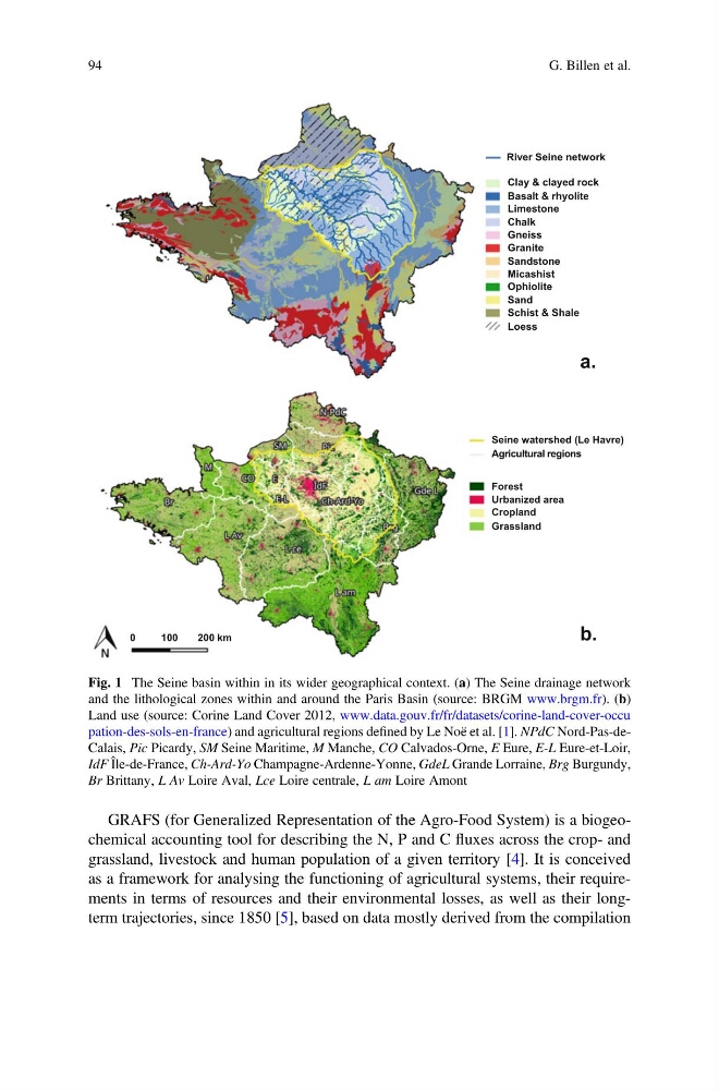
Fig. 1 The Seine basin within in its wider geographical context. (a) The Seine drainage network
and the lithological zones within and around the Paris Basin (source: BRGM www.brgm.fr). (b)
Land use (source: Corine Land Cover 2012, www.data.gouv.fr/fr/datasets/corine-land-cover-occu
pation-des-sols-en-france) and agricultural regions defined by Le Noë et al. [1]. NPdC Nord-Pas-deCalais, Pic Picardy, SM Seine Maritime, M Manche, CO Calvados-Orne, E Eure, E-L Eure-et-Loir,
IdF Île-de-France, Ch-Ard-Yo Champagne-Ardenne-Yonne, GdeL Grande Lorraine, Brg Burgundy,
Br Brittany, L Av Loire Aval, Lce Loire centrale, L am Loire Amont
94
G. Billen et al.
grassland, livestock and human population of a given territory [4]. It is conceived
as a framework for analysing the functioning of agricultural systems, their requirements in terms of resources and their environmental losses, as well as their longterm trajectories, since 1850 [5], based on data mostly derived from the compilation
Clay & clayed rock
Basalt & rhyolite
Limestone
Chalk
Gneiss
Granite
Sandstone
Micashist
Ophiolite
Sand
Schist & Shale
Loess
a.
River Seine network
Forest
Urbanized area
Cropland
Grassland
Agricultural regions
Seine watershed (Le Havre)
b.
0
100
200 km
Fig. 1 The Seine basin within in its wider geographical context. (a) The Seine drainage network
and the lithological zones within and around the Paris Basin (source: BRGM www.brgm.fr). (b)
Land use (source: Corine Land Cover 2012, www.data.gouv.fr/fr/datasets/corine-land-cover-occu
pation-des-sols-en-france) and agricultural regions defined by Le Noë et al. [1]. NPdC Nord-Pas-deCalais, Pic Picardy, SM Seine Maritime, M Manche, CO Calvados-Orne, E Eure, E-L Eure-et-Loir,
IdF Île-de-France, Ch-Ard-Yo Champagne-Ardenne-Yonne, GdeL Grande Lorraine, Brg Burgundy,
Br Brittany, L Av Loire Aval, Lce Loire centrale, L am Loire Amont
94
G. Billen et al.