

42
upper part of the soil dries up, its air regime improves, and oxidative processes
develop that lead to the formation of ferric hydroxides. Under conditions of constant
excess moisture (in wetlands and in the location of groundwater), iron (II) reacts
with silica and alumina to form secondary aluminoferrosilicates having a gray,
greenish, or bluish color. When they accumulate in the soil, a gleyed horizon is
formed (Kulakovsky et al. 1974).
Alluvial soils develop in the river floodplains on alluvial sediments under the
influence of prolonged flooding during the spring and summer-autumn floods. In
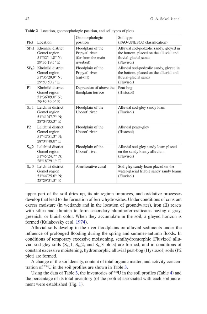
conditions of temporary excessive moistening, semihydromorphic (Fluvizol) alluvial sod-gley soils (S SL 1, S SL 2, and S SL 3 plots) are formed, and in conditions of
constant excessive moistening, hydromorphic alluvial peat-bog (Hystozol) soils (P2
plot) are formed.
A change of the soil density, content of total organic matter, and activity concentration of
238
U in the soil profiles are shown in Table 3.
Using the data of Table 3, the inventories of
238
U in the soil profiles (Table 4) and
the percentage of its total inventory (of the profile) associated with each soil increment were established (Fig. 1).
Table 2 Location, geomorphologic position, and soil types of plots
Plot Location
Geomorphologic
position
Soil type
(FAO-UNESCO classification)
SP S 1 Khoiniki district
Gomel region
51°32′11.8″ N;
29
o 56′19.5″ E
Floodplain of the
Pripyat’ river
(far from the main
riverbed)
Alluvial sod-podzolic sandу, gleyed in
the bottom, placed on the alluvial and
fluvial-glacial sands
(Fluvisol)
SP S 2 Khoiniki district
Gomel region
51°35′29.9″ N;
29
o 50′50.7″ E
Floodplain of the
Pripyat’ river
(cut-off)
Alluvial sod-podzolic sandy, gleyed in
the bottom, placed on the alluvial and
fluvial-glacial sands
(Fluvisol)
P1
Khoiniki district
Gomel region
51°36′09.0″ N;
29
o 59′39.9″ E
Depression of above the
floodplain terrace
Peat-bog
(Histosol)
S SL 1 Lelchitsi district
Gomel region
51°41′47.7′′ N;
28°04′35.3′′ E
Floodplain of the
Uborot’ river
Alluvial sod-gley sandy loam
(Fluvisol)
P2
Lelchitsi district
Gomel region
51°42′51,3′′ N;
28°04′48.0′′ E
Floodplain of the
Uborot’ river
Alluvial peaty-gley
(Histosol)
S SL 2 Lelchitsi district
Gomel region
51°45′24.7′′ N;
28°18′29.1′′ E
Floodplain of the
Uborot’ river
Alluvial sod-gley sandy loam placed
on the sandy loamу alluvium
(Fluvisol)
S SL 3 Lelchitsi district
Gomel region
51°44′25.6′′ N;
28°29′51.5′′ E
Ameliorative canal
Sod-gley sandy loam placed on the
water-glacial friable sandy sandy loams
(Fluvisol)
G. A. Sokolik et al.
upper part of the soil dries up, its air regime improves, and oxidative processes
develop that lead to the formation of ferric hydroxides. Under conditions of constant
excess moisture (in wetlands and in the location of groundwater), iron (II) reacts
with silica and alumina to form secondary aluminoferrosilicates having a gray,
greenish, or bluish color. When they accumulate in the soil, a gleyed horizon is
formed (Kulakovsky et al. 1974).
Alluvial soils develop in the river floodplains on alluvial sediments under the
influence of prolonged flooding during the spring and summer-autumn floods. In
conditions of temporary excessive moistening, semihydromorphic (Fluvizol) alluvial sod-gley soils (S SL 1, S SL 2, and S SL 3 plots) are formed, and in conditions of
constant excessive moistening, hydromorphic alluvial peat-bog (Hystozol) soils (P2
plot) are formed.
A change of the soil density, content of total organic matter, and activity concentration of
238
U in the soil profiles are shown in Table 3.
Using the data of Table 3, the inventories of
238
U in the soil profiles (Table 4) and
the percentage of its total inventory (of the profile) associated with each soil increment were established (Fig. 1).
Table 2 Location, geomorphologic position, and soil types of plots
Plot Location
Geomorphologic
position
Soil type
(FAO-UNESCO classification)
SP S 1 Khoiniki district
Gomel region
51°32′11.8″ N;
29
o 56′19.5″ E
Floodplain of the
Pripyat’ river
(far from the main
riverbed)
Alluvial sod-podzolic sandу, gleyed in
the bottom, placed on the alluvial and
fluvial-glacial sands
(Fluvisol)
SP S 2 Khoiniki district
Gomel region
51°35′29.9″ N;
29
o 50′50.7″ E
Floodplain of the
Pripyat’ river
(cut-off)
Alluvial sod-podzolic sandy, gleyed in
the bottom, placed on the alluvial and
fluvial-glacial sands
(Fluvisol)
P1
Khoiniki district
Gomel region
51°36′09.0″ N;
29
o 59′39.9″ E
Depression of above the
floodplain terrace
Peat-bog
(Histosol)
S SL 1 Lelchitsi district
Gomel region
51°41′47.7′′ N;
28°04′35.3′′ E
Floodplain of the
Uborot’ river
Alluvial sod-gley sandy loam
(Fluvisol)
P2
Lelchitsi district
Gomel region
51°42′51,3′′ N;
28°04′48.0′′ E
Floodplain of the
Uborot’ river
Alluvial peaty-gley
(Histosol)
S SL 2 Lelchitsi district
Gomel region
51°45′24.7′′ N;
28°18′29.1′′ E
Floodplain of the
Uborot’ river
Alluvial sod-gley sandy loam placed
on the sandy loamу alluvium
(Fluvisol)
S SL 3 Lelchitsi district
Gomel region
51°44′25.6′′ N;
28°29′51.5′′ E
Ameliorative canal
Sod-gley sandy loam placed on the
water-glacial friable sandy sandy loams
(Fluvisol)
G. A. Sokolik et al.