

60
5 How to Conduct an Experiment in the Field …
Gravity erosion, the mass failure on steep slopes that is triggered by self-weight,
contrasted with other types of soil erosion requiring physical impetus of wind or
water, is among the most important natural hazards in mountainous regions (Hergarten 2012; Gokceoglu and Sezer 2009). Gravity erosion tends to happen as an
episodic event in which large sections of the steep slope fail. However, to monitor
the time-variable process of an individual mass failure is very difficult because of
the randomness and suddenness of such an event. It is rather difficult to conduct a
field survey of soil and water conservation on the Loess Plateau of China. During
the natural rainfall events, the site-specific observation of gravity erosion is almost
impossible, because we are unable to predict when and where the gravity erosion will
occur. Hence, what we could do is to simulate the landslide processes by employing a
conceptual slope under rainfall simulation. However, the representative catchments
on the Chinese Loess Plateau for scientific research are generally far from urban
areas, lack water and electricity, and have deep ditches, steep slopes, inconvenient
transportation, and high-strength winds. The special situation poses another severe
challenge to the site survey. Here, we designed a removable house that could be
assembled in the field to conduct site-specific tests based on the terrain of the Loess
Plateau. The room provided the same conditions for simulations and observations as
those in the laboratory. We also presented a detailed illustration of the MX-2010-G
topography meter to dynamically monitor the slope behavior under rainfall simulation. The design optimization and fabrication methods of the topography meter and
the laboratory would be expected to be useful for congeneric device applications.
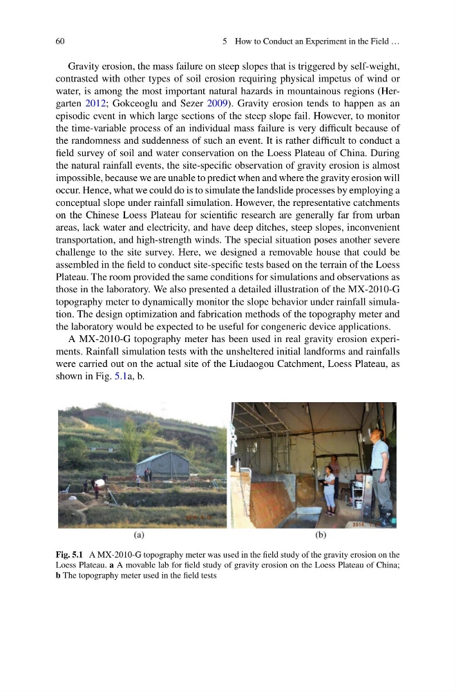
A MX-2010-G topography meter has been used in real gravity erosion experiments. Rainfall simulation tests with the unsheltered initial landforms and rainfalls
were carried out on the actual site of the Liudaogou Catchment, Loess Plateau, as
shown in Fig. 5.1a, b.
Fig. 5.1 A MX-2010-G topography meter was used in the field study of the gravity erosion on the
Loess Plateau. a A movable lab for field study of gravity erosion on the Loess Plateau of China;
b The topography meter used in the field tests
5 How to Conduct an Experiment in the Field …
Gravity erosion, the mass failure on steep slopes that is triggered by self-weight,
contrasted with other types of soil erosion requiring physical impetus of wind or
water, is among the most important natural hazards in mountainous regions (Hergarten 2012; Gokceoglu and Sezer 2009). Gravity erosion tends to happen as an
episodic event in which large sections of the steep slope fail. However, to monitor
the time-variable process of an individual mass failure is very difficult because of
the randomness and suddenness of such an event. It is rather difficult to conduct a
field survey of soil and water conservation on the Loess Plateau of China. During
the natural rainfall events, the site-specific observation of gravity erosion is almost
impossible, because we are unable to predict when and where the gravity erosion will
occur. Hence, what we could do is to simulate the landslide processes by employing a
conceptual slope under rainfall simulation. However, the representative catchments
on the Chinese Loess Plateau for scientific research are generally far from urban
areas, lack water and electricity, and have deep ditches, steep slopes, inconvenient
transportation, and high-strength winds. The special situation poses another severe
challenge to the site survey. Here, we designed a removable house that could be
assembled in the field to conduct site-specific tests based on the terrain of the Loess
Plateau. The room provided the same conditions for simulations and observations as
those in the laboratory. We also presented a detailed illustration of the MX-2010-G
topography meter to dynamically monitor the slope behavior under rainfall simulation. The design optimization and fabrication methods of the topography meter and
the laboratory would be expected to be useful for congeneric device applications.
A MX-2010-G topography meter has been used in real gravity erosion experiments. Rainfall simulation tests with the unsheltered initial landforms and rainfalls
were carried out on the actual site of the Liudaogou Catchment, Loess Plateau, as
shown in Fig. 5.1a, b.
Fig. 5.1 A MX-2010-G topography meter was used in the field study of the gravity erosion on the
Loess Plateau. a A movable lab for field study of gravity erosion on the Loess Plateau of China;
b The topography meter used in the field tests