

2.3 Similarity Requirements
13
that the ratio R is constant for the semi-scale model: (1) The bare-land model with
a corresponding erosion rate is employed in the experiment. (2) The dimensions of
the landform, including the check dams, are scaled down according to the prototype
watershed with the same proportions in the horizontal and vertical orientation. (3)
The soil is similar to that in the prototype. (4) The initial water content in the soil
layer before each simulated rainfall event remains constant.
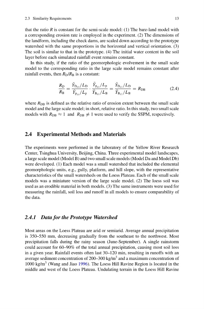
In this study, if the ratio of the geomorphologic evolvement in the small scale
model to the corresponding ratio in the large scale model remains constant after
rainfall events, then R D /R B is a constant:
R D
R B
=
¯
Y D (i) /L D
¯
Y p (i) /L p
·
¯
Y p (i) /L p
¯
Y B (i) /L B
=
¯
Y D (i) /L D
¯
Y B (i) /L B
= R DB
(2.4)
where R DB is defined as the relative ratio of erosion extent between the small scale
model and the large scale model; in short, relative ratio. In this study, two small scale
models with R DB ≈ 1 and R DB = 1 were used to verify the SSPM, respectively.
2.4 Experimental Methods and Materials
The experiments were performed in the laboratory of the Yellow River Research
Center, Tsinghua University, Beijing, China. Three experimental model landscapes,
a large scale model (Model B) and two small scale models (Model Da and Model Db)
were developed. (1) Each model was a small watershed that included the elemental
geomorphologic units, e.g., gully, platform, and hill slope, with the representative
characteristics of the small watersheds on the Loess Plateau. Each of the small scale
models was a miniature version of the large scale model. (2) The loess soil was
used as an erodible material in both models. (3) The same instruments were used for
measuring the rainfall, soil loss and runoff in all models to ensure comparability of
the data.
2.4.1 Data for the Prototype Watershed
Most areas on the Loess Plateau are arid or semiarid. Average annual precipitation
is 350–550 mm, decreasing gradually from the southeast to the northwest. Most
precipitation falls during the rainy season (June-September). A single rainstorm
could account for 60–90% of the total annual precipitation, causing most soil loss
in a given year. Rainfall events often last 30–120 min, resulting in runoffs with an
average sediment concentration of 200–300 kg/m
3 and a maximum concentration of
1000 kg/m
3 (Wang and Jiao 1996). The Loess Hill Ravine Region is located in the
middle and west of the Loess Plateau. Undulating terrain in the Loess Hill Ravine
13
that the ratio R is constant for the semi-scale model: (1) The bare-land model with
a corresponding erosion rate is employed in the experiment. (2) The dimensions of
the landform, including the check dams, are scaled down according to the prototype
watershed with the same proportions in the horizontal and vertical orientation. (3)
The soil is similar to that in the prototype. (4) The initial water content in the soil
layer before each simulated rainfall event remains constant.
In this study, if the ratio of the geomorphologic evolvement in the small scale
model to the corresponding ratio in the large scale model remains constant after
rainfall events, then R D /R B is a constant:
R D
R B
=
¯
Y D (i) /L D
¯
Y p (i) /L p
·
¯
Y p (i) /L p
¯
Y B (i) /L B
=
¯
Y D (i) /L D
¯
Y B (i) /L B
= R DB
(2.4)
where R DB is defined as the relative ratio of erosion extent between the small scale
model and the large scale model; in short, relative ratio. In this study, two small scale
models with R DB ≈ 1 and R DB = 1 were used to verify the SSPM, respectively.
2.4 Experimental Methods and Materials
The experiments were performed in the laboratory of the Yellow River Research
Center, Tsinghua University, Beijing, China. Three experimental model landscapes,
a large scale model (Model B) and two small scale models (Model Da and Model Db)
were developed. (1) Each model was a small watershed that included the elemental
geomorphologic units, e.g., gully, platform, and hill slope, with the representative
characteristics of the small watersheds on the Loess Plateau. Each of the small scale
models was a miniature version of the large scale model. (2) The loess soil was
used as an erodible material in both models. (3) The same instruments were used for
measuring the rainfall, soil loss and runoff in all models to ensure comparability of
the data.
2.4.1 Data for the Prototype Watershed
Most areas on the Loess Plateau are arid or semiarid. Average annual precipitation
is 350–550 mm, decreasing gradually from the southeast to the northwest. Most
precipitation falls during the rainy season (June-September). A single rainstorm
could account for 60–90% of the total annual precipitation, causing most soil loss
in a given year. Rainfall events often last 30–120 min, resulting in runoffs with an
average sediment concentration of 200–300 kg/m
3 and a maximum concentration of
1000 kg/m
3 (Wang and Jiao 1996). The Loess Hill Ravine Region is located in the
middle and west of the Loess Plateau. Undulating terrain in the Loess Hill Ravine