

128
8 Sediment-Storage Effects of Check-Dam …
such as reservoirs, retention ponds, etc., the check-dam can slow down the velocity
of the sediment-laden water, resulting in a lower sediment transport capacity. Thus,
some of the sediments would sink, and the sediment concentration in the outlet would
become smaller than that in the inlet. Moreover, before the next runoff, the sedimentladen fluid stored in the reservoir would become clear, and some sediment would be
left on the dam-land to prevent the dam-land from erosion.
On the other hand, development of a “shielding” layer composed of relatively
heavy soil particles could protect the underlying soil from runoff erosion. When the
soil surface was initially inundated with runoffs, the soil particles were detached
from the soil surface and were entrained into the gully flow. Lighter particles with
low settling rates would move far away from their original locations, whilst heavier
particles would settle more quickly near their original positions. If this process was
continued, eventually most of the lighter particles would be removed, leaving a
shielding layer of heavier particles, which could act to protect the underlying soil.
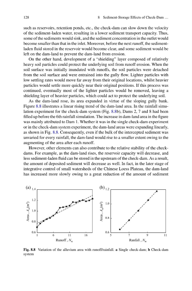
As the dam-land rose, its area expanded in virtue of the sloping gully bank.
Figure 8.8 illustrates a linear rising trend of the dam-land area. In the rainfall simulation experiment for the check-dam system (Fig. 8.8b), Dams 2, 7 and 8 had been
filled up before the 6th rainfall simulation. The increase in dam-land area in the figure
was mainly attributed to Dam 1. Whether it was in the single check-dam experiment
or in the check-dam system experiment, the dam-land areas were expanding linearly,
as shown in Fig. 8.8. Consequently, even if the bulk of the intercepted sediment was
unvaried for every rainfall, the dam-land would rise to a smaller extent owing to the
augmenting of the area after each runoff.
However, other elements can also contribute to the relative stability of the checkdams. For example, as the dam-land rises, the reservoir capacity will decrease, and
less sediment-laden fluid can be stored in the upstream of the check-dam. As a result,
the amount of deposited sediment will decrease as well. In fact, in the later stage of
integrative control of small watersheds of the Chinese Loess Plateau, the dam-land
has increased more slowly owing to a great reduction of the amount of sediment
0.6
0.8
1.0
1.2
1.4
1
6
11
16
Area , A
m (m
2
)
Area , A
m (m
2
)
Runoff , N m
0.6
0.8
1.0
1.2
5
7
9
1 1
Ranfall , N m
(a)
(b)
Fig. 8.8 Variation of the alluvium area with runoff/rainfall. a Single check-dam; b Check-dam
system
8 Sediment-Storage Effects of Check-Dam …
such as reservoirs, retention ponds, etc., the check-dam can slow down the velocity
of the sediment-laden water, resulting in a lower sediment transport capacity. Thus,
some of the sediments would sink, and the sediment concentration in the outlet would
become smaller than that in the inlet. Moreover, before the next runoff, the sedimentladen fluid stored in the reservoir would become clear, and some sediment would be
left on the dam-land to prevent the dam-land from erosion.
On the other hand, development of a “shielding” layer composed of relatively
heavy soil particles could protect the underlying soil from runoff erosion. When the
soil surface was initially inundated with runoffs, the soil particles were detached
from the soil surface and were entrained into the gully flow. Lighter particles with
low settling rates would move far away from their original locations, whilst heavier
particles would settle more quickly near their original positions. If this process was
continued, eventually most of the lighter particles would be removed, leaving a
shielding layer of heavier particles, which could act to protect the underlying soil.
As the dam-land rose, its area expanded in virtue of the sloping gully bank.
Figure 8.8 illustrates a linear rising trend of the dam-land area. In the rainfall simulation experiment for the check-dam system (Fig. 8.8b), Dams 2, 7 and 8 had been
filled up before the 6th rainfall simulation. The increase in dam-land area in the figure
was mainly attributed to Dam 1. Whether it was in the single check-dam experiment
or in the check-dam system experiment, the dam-land areas were expanding linearly,
as shown in Fig. 8.8. Consequently, even if the bulk of the intercepted sediment was
unvaried for every rainfall, the dam-land would rise to a smaller extent owing to the
augmenting of the area after each runoff.
However, other elements can also contribute to the relative stability of the checkdams. For example, as the dam-land rises, the reservoir capacity will decrease, and
less sediment-laden fluid can be stored in the upstream of the check-dam. As a result,
the amount of deposited sediment will decrease as well. In fact, in the later stage of
integrative control of small watersheds of the Chinese Loess Plateau, the dam-land
has increased more slowly owing to a great reduction of the amount of sediment
0.6
0.8
1.0
1.2
1.4
1
6
11
16
Area , A
m (m
2
)
Area , A
m (m
2
)
Runoff , N m
0.6
0.8
1.0
1.2
5
7
9
1 1
Ranfall , N m
(a)
(b)
Fig. 8.8 Variation of the alluvium area with runoff/rainfall. a Single check-dam; b Check-dam
system