

438
selected bays and estuaries, where high-resolution monitoring was based on markrecapture analysis (Wells 2014).
Offshore turtle surveys using aerial and shipboard methods have limitations
because small turtles are difficult to detect and identify using these methods,
although using satellite tags to monitor diving behavior to account for sightability
may reduce uncertainty in estimates (Thomas et al. 2010; Seminoff et al. 2014).
Beach counts of nesting females and clutch sizes are a reliable census method
(Schroeder and Murphy 1999), but this approach only surveys adult females nesting
in a given year (nesting cycles differ between species). Satellite systems and drones
are now being adopted to survey sea turtles, and satellite tags are being used to track
their movement over large distances (Rees et al. 2018).
26.3.2 Study Methods: Post-DWH
In response to the DWH event, numerous additional studies were initiated in the
GOM to understand potential impacts from the spill. The longest-term marine mammal study was the GOM High-frequency Acoustic Recording Package (HARP) program based on passive acoustic monitoring of marine mammal sounds (Hildebrand
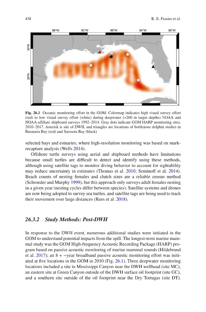
et al. 2017); an 8 + −year broadband passive acoustic monitoring effort was initiated at five locations in the GOM in 2010 (Fig. 26.1). Three deepwater monitoring
locations included a site in Mississippi Canyon near the DWH wellhead (site MC),
an eastern site at Green Canyon outside of the DWH surface oil footprint (site GC),
and a southern site outside of the oil footprint near the Dry Tortugas (site DT).
Fig. 26.1 Oceanic monitoring effort in the GOM. Colormap indicates high visual survey effort
(red) to low visual survey effort (white) during deepwater (>200 m target depths) NOAA and
NOAA-affiliate shipboard surveys 1992–2014. Gray dots indicate GOM HARP monitoring sites,
2010–2017. Asterisk is site of DWH, and triangles are locations of bottlenose dolphin studies in
Barataria Bay (red) and Sarasota Bay (black)
K. E. Frasier et al.
selected bays and estuaries, where high-resolution monitoring was based on markrecapture analysis (Wells 2014).
Offshore turtle surveys using aerial and shipboard methods have limitations
because small turtles are difficult to detect and identify using these methods,
although using satellite tags to monitor diving behavior to account for sightability
may reduce uncertainty in estimates (Thomas et al. 2010; Seminoff et al. 2014).
Beach counts of nesting females and clutch sizes are a reliable census method
(Schroeder and Murphy 1999), but this approach only surveys adult females nesting
in a given year (nesting cycles differ between species). Satellite systems and drones
are now being adopted to survey sea turtles, and satellite tags are being used to track
their movement over large distances (Rees et al. 2018).
26.3.2 Study Methods: Post-DWH
In response to the DWH event, numerous additional studies were initiated in the
GOM to understand potential impacts from the spill. The longest-term marine mammal study was the GOM High-frequency Acoustic Recording Package (HARP) program based on passive acoustic monitoring of marine mammal sounds (Hildebrand
et al. 2017); an 8 + −year broadband passive acoustic monitoring effort was initiated at five locations in the GOM in 2010 (Fig. 26.1). Three deepwater monitoring
locations included a site in Mississippi Canyon near the DWH wellhead (site MC),
an eastern site at Green Canyon outside of the DWH surface oil footprint (site GC),
and a southern site outside of the oil footprint near the Dry Tortugas (site DT).
Fig. 26.1 Oceanic monitoring effort in the GOM. Colormap indicates high visual survey effort
(red) to low visual survey effort (white) during deepwater (>200 m target depths) NOAA and
NOAA-affiliate shipboard surveys 1992–2014. Gray dots indicate GOM HARP monitoring sites,
2010–2017. Asterisk is site of DWH, and triangles are locations of bottlenose dolphin studies in
Barataria Bay (red) and Sarasota Bay (black)
K. E. Frasier et al.