

314
Initial attempts to plug the damaged well and divert oil via relief wells were
unsuccessful, and the release of oil from the Ixtoc 1 well continued from June 3,
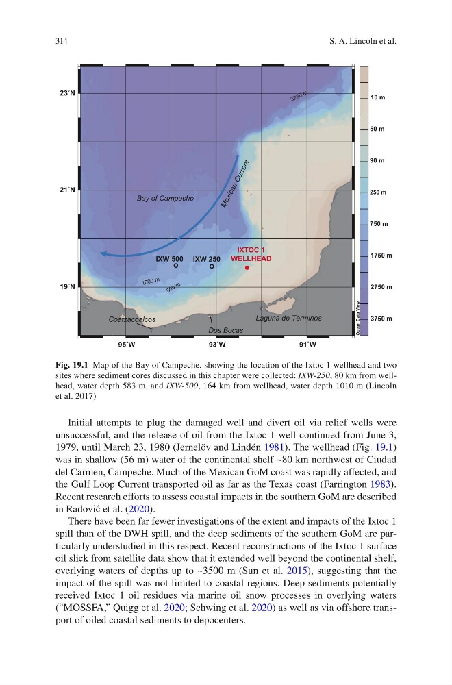
1979, until March 23, 1980 (Jernelöv and Lindén 1981). The wellhead (Fig. 19.1)
was in shallow (56 m) water of the continental shelf ~80 km northwest of Ciudad
del Carmen, Campeche. Much of the Mexican GoM coast was rapidly affected, and
the Gulf Loop Current transported oil as far as the Texas coast (Farrington 1983).
Recent research efforts to assess coastal impacts in the southern GoM are described
in Radović et al. (2020).
There have been far fewer investigations of the extent and impacts of the Ixtoc 1
spill than of the DWH spill, and the deep sediments of the southern GoM are particularly understudied in this respect. Recent reconstructions of the Ixtoc 1 surface
oil slick from satellite data show that it extended well beyond the continental shelf,
overlying waters of depths up to ~3500 m (Sun et al. 2015), suggesting that the
impact of the spill was not limited to coastal regions. Deep sediments potentially
received Ixtoc 1 oil residues via marine oil snow processes in overlying waters
(“MOSSFA,” Quigg et al. 2020; Schwing et al. 2020) as well as via offshore transport of oiled coastal sediments to depocenters.
Û:
Û:
Û:
Û1
Û1
Û1
2FHDQ'DWD9LHZ
P
P
P
P
P
P
P
P
,;72&
:(//+($'
,;:
,;:
%D\RI&DPSHFKH
/DJXQDGH7pUPLQRV
P
P
P
'RV%RFDV
&RDW]DFRDOFRV
0 H [ LF D Q & X U U H Q W
Fig. 19.1 Map of the Bay of Campeche, showing the location of the Ixtoc 1 wellhead and two
sites where sediment cores discussed in this chapter were collected: IXW-250, 80 km from wellhead, water depth 583 m, and IXW-500, 164 km from wellhead, water depth 1010 m (Lincoln
et al. 2017)
S. A. Lincoln et al.
Initial attempts to plug the damaged well and divert oil via relief wells were
unsuccessful, and the release of oil from the Ixtoc 1 well continued from June 3,
1979, until March 23, 1980 (Jernelöv and Lindén 1981). The wellhead (Fig. 19.1)
was in shallow (56 m) water of the continental shelf ~80 km northwest of Ciudad
del Carmen, Campeche. Much of the Mexican GoM coast was rapidly affected, and
the Gulf Loop Current transported oil as far as the Texas coast (Farrington 1983).
Recent research efforts to assess coastal impacts in the southern GoM are described
in Radović et al. (2020).
There have been far fewer investigations of the extent and impacts of the Ixtoc 1
spill than of the DWH spill, and the deep sediments of the southern GoM are particularly understudied in this respect. Recent reconstructions of the Ixtoc 1 surface
oil slick from satellite data show that it extended well beyond the continental shelf,
overlying waters of depths up to ~3500 m (Sun et al. 2015), suggesting that the
impact of the spill was not limited to coastal regions. Deep sediments potentially
received Ixtoc 1 oil residues via marine oil snow processes in overlying waters
(“MOSSFA,” Quigg et al. 2020; Schwing et al. 2020) as well as via offshore transport of oiled coastal sediments to depocenters.
Û:
Û:
Û:
Û1
Û1
Û1
2FHDQ'DWD9LHZ
P
P
P
P
P
P
P
P
,;72&
:(//+($'
,;:
,;:
%D\RI&DPSHFKH
/DJXQDGH7pUPLQRV
P
P
P
'RV%RFDV
&RDW]DFRDOFRV
0 H [ LF D Q & X U U H Q W
Fig. 19.1 Map of the Bay of Campeche, showing the location of the Ixtoc 1 wellhead and two
sites where sediment cores discussed in this chapter were collected: IXW-250, 80 km from wellhead, water depth 583 m, and IXW-500, 164 km from wellhead, water depth 1010 m (Lincoln
et al. 2017)
S. A. Lincoln et al.