

Chapter III
Numerical Modeling
36
mesh generator provides two interpolation options specifically for triangular elements. These
two possible interpolation methods are the nearest neighbor and linear interpolation (DHI, 2014).
In our case, we have chosen the nearest neighbor interpolation method. This method involves
assigning the value of the nearest bathymetry point to each corresponding node or element in the
mesh. By utilizing this interpolation approach, we ensure that each node or element in the mesh
is associated with the bathymetry value of the closest point.
The nearest neighbor interpolation method is particularly useful when accuracy and preservation
of sharp features or abrupt changes in bathymetry are crucial. It provides a straightforward and
efficient way to transfer bathymetry information onto the mesh, allowing for accurate
representation of the underwater topography in the simulation.
III.3.2. Mesh and bathymetry results
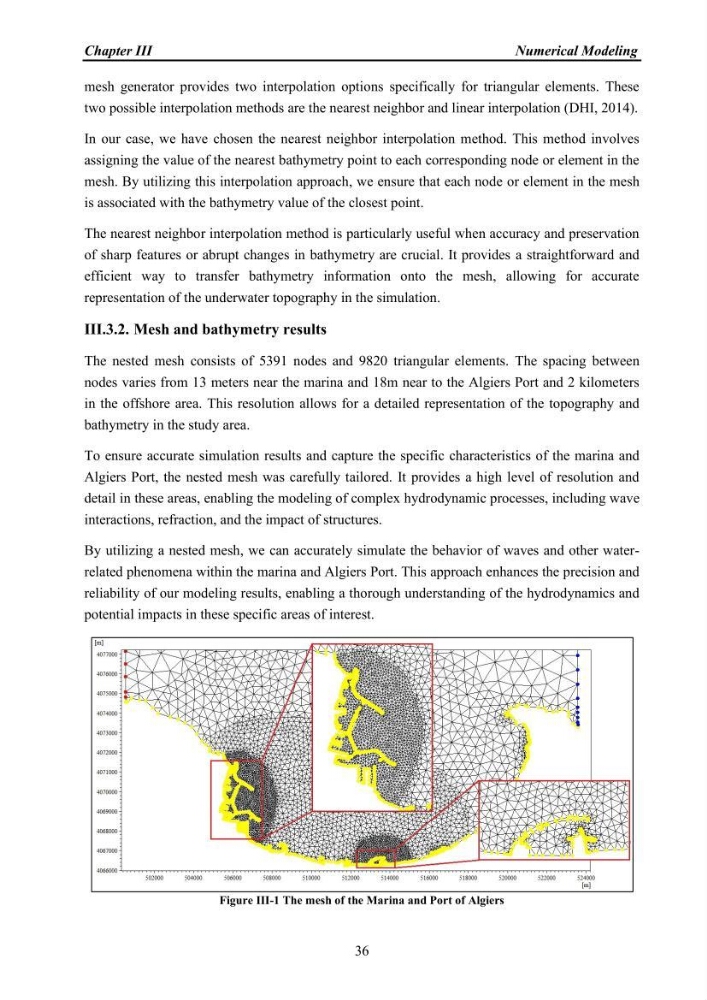
The nested mesh consists of 5391 nodes and 9820 triangular elements. The spacing between
nodes varies from 13 meters near the marina and 18m near to the Algiers Port and 2 kilometers
in the offshore area. This resolution allows for a detailed representation of the topography and
bathymetry in the study area.
To ensure accurate simulation results and capture the specific characteristics of the marina and
Algiers Port, the nested mesh was carefully tailored. It provides a high level of resolution and
detail in these areas, enabling the modeling of complex hydrodynamic processes, including wave
interactions, refraction, and the impact of structures.
By utilizing a nested mesh, we can accurately simulate the behavior of waves and other waterrelated phenomena within the marina and Algiers Port. This approach enhances the precision and
reliability of our modeling results, enabling a thorough understanding of the hydrodynamics and
potential impacts in these specific areas of interest.
Figure III-1 The mesh of the Marina and Port of Algiers
Numerical Modeling
36
mesh generator provides two interpolation options specifically for triangular elements. These
two possible interpolation methods are the nearest neighbor and linear interpolation (DHI, 2014).
In our case, we have chosen the nearest neighbor interpolation method. This method involves
assigning the value of the nearest bathymetry point to each corresponding node or element in the
mesh. By utilizing this interpolation approach, we ensure that each node or element in the mesh
is associated with the bathymetry value of the closest point.
The nearest neighbor interpolation method is particularly useful when accuracy and preservation
of sharp features or abrupt changes in bathymetry are crucial. It provides a straightforward and
efficient way to transfer bathymetry information onto the mesh, allowing for accurate
representation of the underwater topography in the simulation.
III.3.2. Mesh and bathymetry results
The nested mesh consists of 5391 nodes and 9820 triangular elements. The spacing between
nodes varies from 13 meters near the marina and 18m near to the Algiers Port and 2 kilometers
in the offshore area. This resolution allows for a detailed representation of the topography and
bathymetry in the study area.
To ensure accurate simulation results and capture the specific characteristics of the marina and
Algiers Port, the nested mesh was carefully tailored. It provides a high level of resolution and
detail in these areas, enabling the modeling of complex hydrodynamic processes, including wave
interactions, refraction, and the impact of structures.
By utilizing a nested mesh, we can accurately simulate the behavior of waves and other waterrelated phenomena within the marina and Algiers Port. This approach enhances the precision and
reliability of our modeling results, enabling a thorough understanding of the hydrodynamics and
potential impacts in these specific areas of interest.
Figure III-1 The mesh of the Marina and Port of Algiers