

CHAPTER IV
Results & Discussion
63
concentrated along the two main dynamic axes of the region, which include the Azzaba and Elharrouche regions. Approximately 71% of the agricultural land in the region is located in these
areas, which produce the majority of the agricultural output. Agriculture remains one of the
primary sectors of economic activity in the region, along with industry (ANIREF 2020).
Table 5: The agricultural area by municipality (ANIREF 2020).
Municipalities
Agriculture area (Ha)
Total coastal municipalities 50006,85
Total Wilaya
193024
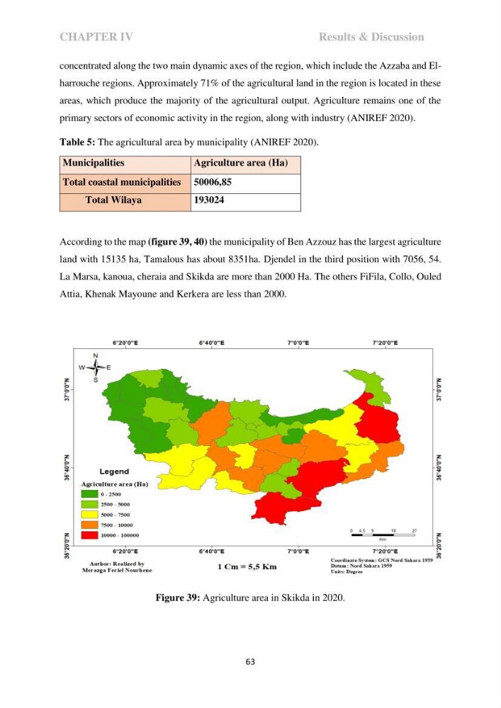
According to the map (figure 39, 40) the municipality of Ben Azzouz has the largest agriculture
land with 15135 ha, Tamalous has about 8351ha. Djendel in the third position with 7056, 54.
La Marsa, kanoua, cheraia and Skikda are more than 2000 Ha. The others FiFila, Collo, Ouled
Attia, Khenak Mayoune and Kerkera are less than 2000.
Figure 39: Agriculture area in Skikda in 2020.
Results & Discussion
63
concentrated along the two main dynamic axes of the region, which include the Azzaba and Elharrouche regions. Approximately 71% of the agricultural land in the region is located in these
areas, which produce the majority of the agricultural output. Agriculture remains one of the
primary sectors of economic activity in the region, along with industry (ANIREF 2020).
Table 5: The agricultural area by municipality (ANIREF 2020).
Municipalities
Agriculture area (Ha)
Total coastal municipalities 50006,85
Total Wilaya
193024
According to the map (figure 39, 40) the municipality of Ben Azzouz has the largest agriculture
land with 15135 ha, Tamalous has about 8351ha. Djendel in the third position with 7056, 54.
La Marsa, kanoua, cheraia and Skikda are more than 2000 Ha. The others FiFila, Collo, Ouled
Attia, Khenak Mayoune and Kerkera are less than 2000.
Figure 39: Agriculture area in Skikda in 2020.